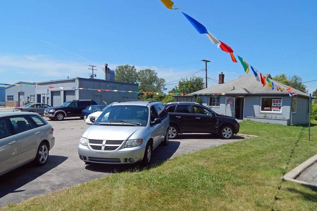
Property Record
26796 Telegraph Rd, Flat Rock, MI 48134


NEARBY LISTINGS FOR SALE OR LEASE
Property Detail
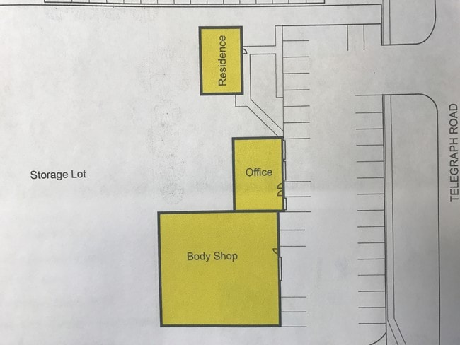
26796 Telegraph Rd
58-090-99-0021-000
30AA5 TO AA7 T4S THAT PART OF SECTIONS 29 AND 30 T4S R10E DESCRIBED AS BEGINNING AT A POINT ON THE CENTER LINE OF TELEGRAPH RD DISTANT N 0D 17M W 427.71 FT AND N 26D 03M E 299.27 FT FROM THE SW CORNER OF SEC 29 AND PROCEEDING TH N 26D 03M E ALONG SAI
Officebuilding
Wayne
AE
Michigan
26115C0110E
0021
2025
1.34 AC
2025
Downriver South
599001
Detroit
7,602 SF
Detroit-Warren-Dearborn, MI
DEMOGRAPHICS near 26796 Telegraph Rd
1 Mile
3 Mile
5 Mile
2024 Total Population
6,064
39,818
80,231
2029 Population
5,851
38,319
77,338
Pop Growth 2024-2029
(3.51%)
(3.76%)
(3.61%)
Average Age
40
41
42
2024 Total Households
2,377
15,642
31,992
HH Growth 2024-2029
(3.53%)
(3.74%)
(3.59%)
Median Household Inc
$76,044
$79,294
$78,601
Avg Household Size
2.50
2.50
2.50
2024 Avg HH Vehicles
2.00
2.00
2.00
Median Home Value
$205,485
$233,430
$219,586
Median Year Built
1989
1989
1979
Nearby Places
Map Layers
Map Styles
 Street
 Aerial
- Restaurants
- Banks
- Shops
- Fitness
- Groceries
PUBLIC TRANSPORTATION
AIRPORT
Detroit Metro Wayne County
DRIVE
WALK
Distance
Detroit Metro Wayne County
20 min
12.0 mi
Windsor International
DRIVE
WALK
Distance
Windsor International
48 min
30.0 mi
Freight Ports
Port of Toledo
DRIVE
WALK
Distance
Port of Toledo
53 min
39.8 mi
SALE & LEASE HISTORY
LISTING DATE
SALE/LEASE

Aug 11, 2017
For Sale
Apr 14, 2017
For Sale
Nearby Properties
Address
Land Use
TOTAL SIZE
Lot Size
Zoning
Address
Land Use
TOTAL SIZE
Lot Size
Zoning
3,189,689 SF
228.88 AC
Address
Land Use
TOTAL SIZE
Lot Size
Zoning
215,724 SF
Address
Land Use
TOTAL SIZE
Lot Size
Zoning
235,489 SF
23.47 AC
Address
Land Use
TOTAL SIZE
Lot Size
Zoning
177,054 SF
11.88 AC
PUD
Address
Land Use
TOTAL SIZE
Lot Size
Zoning
1,021,918 SF
163.58 AC
Address
Land Use
TOTAL SIZE
Lot Size
Zoning
35.50 AC
RM-1
Address
Land Use
TOTAL SIZE
Lot Size
Zoning
112,726 SF
21.10 AC
TC
Address
Land Use
TOTAL SIZE
Lot Size
Zoning
3,280 SF
99.72 AC
Address
Land Use
TOTAL SIZE
Lot Size
Zoning
4,860 SF
69.40 AC
MHP MOB
Address
Land Use
TOTAL SIZE
Lot Size
Zoning
203,114 SF
14.50 AC
R-M MUL
Address
Land Use
TOTAL SIZE
Lot Size
Zoning
33,600 SF
100.03 AC
Address
Land Use
TOTAL SIZE
Lot Size
Zoning
307,181 SF
22.32 AC
Address
Land Use
TOTAL SIZE
Lot Size
Zoning
61,784 SF
6.78 AC
Address
Land Use
TOTAL SIZE
Lot Size
Zoning
141,861 SF
13 AC
RM-1
Address
Land Use
TOTAL SIZE
Lot Size
Zoning
167,004 SF
19.04 AC
RM-1
Address
Land Use
TOTAL SIZE
Lot Size
Zoning
179,235 SF
25.38 AC
Address
Land Use
TOTAL SIZE
Lot Size
Zoning
59,427 SF
5.50 AC
Address
Land Use
TOTAL SIZE
Lot Size
Zoning
68,409 SF
64.56 AC
Address
Land Use
TOTAL SIZE
Lot Size
Zoning
95,650 SF
73.78 AC
Address
Land Use
TOTAL SIZE
Lot Size
Zoning
52.37 AC
Address
Land Use
TOTAL SIZE
Lot Size
Zoning
3,520 SF
62.97 AC
MHP MOB
Address
Land Use
TOTAL SIZE
Lot Size
Zoning
3,870 SF
38.38 AC
Address
Land Use
TOTAL SIZE
Lot Size
Zoning
146,300 SF
25.84 AC
Address
Land Use
TOTAL SIZE
Lot Size
Zoning
101,861 SF
15.33 AC
B-2
Address
Land Use
TOTAL SIZE
Lot Size
Zoning
69,112 SF
10.34 AC
B-2
Address
Land Use
TOTAL SIZE
Lot Size
Zoning
48,288 SF
22.34 AC
Address
Land Use
TOTAL SIZE
Lot Size
Zoning
69,938 SF
1.74 AC
Address
Land Use
TOTAL SIZE
Lot Size
Zoning
114,165 SF
13.07 AC
Address
Land Use
TOTAL SIZE
Lot Size
Zoning
124,102 SF
17.09 AC
Address
Land Use
TOTAL SIZE
Lot Size
Zoning
44.13 AC
MHP MOB
The World's #1 Commercial Real Estate Marketplace
Connect with us
© 2026 CoStar Group
The information above has been obtained from sources believed reliable. While we do not doubt its accuracy we have not verified it and make no guarantee, warranty or representation about it. It is your responsibility to independently confirm its accuracy and completeness. Any projections, opinions, assumptions, or estimates used are for example only and do not represent the current or future performance of the property. The value of this transaction to you depends on tax and other factors which should be evaluated by your tax, financial, and legal advisors. You and your advisors should conduct a careful, independent investigation of the property to determine to your satisfaction the suitability of the property for your needs.