Property Record
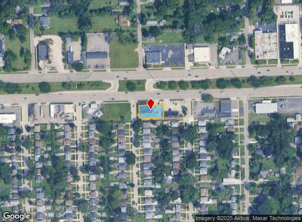
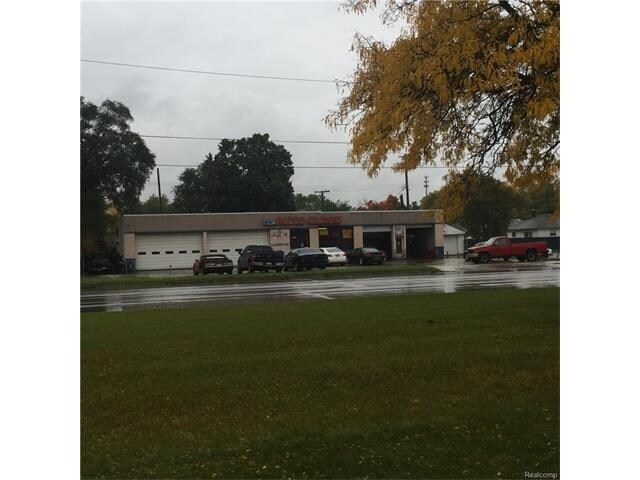
26799 W 8 Mile Rd, Redford, MI 48240

NEARBY LISTINGS FOR SALE OR LEASE
Property Detail
26799 W 8 Mile Rd
Detroit-Warren-Dearborn, MI
Sub
79-004-01-1224-001
06E1224A TO 06E1230A LOTS 1224 TO 1230 COMB EXC NLY PART THEREOF MEAS 9.61FT OF E LINE AND 8.95FT ON W LINE OF SAID COMB PARCEL CHESTERFIELD NO. 4 SUB T1S R10E L60 P5 WCR
Autorepair
Wayne
X
Michigan
26163C0060E
1224
2024
0.26 AC
2025
Southern I-275 Corridor
554100
Detroit
5,200 SF
DEMOGRAPHICS near 26799 W 8 Mile Rd
1 Mile
3 Mile
5 Mile
2024 Total Population
12,140
85,604
236,506
2029 Population
11,854
83,260
230,747
Pop Growth 2024-2029
(2.36%)
(2.74%)
(2.44%)
Average Age
40
41
42
2024 Total Households
5,125
36,318
100,120
HH Growth 2024-2029
(2.28%)
(2.75%)
(2.44%)
Median Household Inc
$54,974
$58,560
$62,056
Avg Household Size
2.30
2.30
2.30
2024 Avg HH Vehicles
2.00
2.00
2.00
Median Home Value
$127,199
$156,599
$181,995
Median Year Built
1957
1958
1960
Nearby Places
Map Layers
Map Styles
 Street
 Aerial
- Restaurants
- Banks
- Shops
- Fitness
- Groceries
PUBLIC TRANSPORTATION
AIRPORT
Detroit City
DRIVE
WALK
Distance
Detroit City
33 min
23.7 mi
Detroit Metro Wayne County
DRIVE
WALK
Distance
Detroit Metro Wayne County
37 min
26.5 mi
SALE & LEASE HISTORY
LISTING DATE
SALE/LEASE

Nov 28, 2016
For Sale
Nearby Properties
Address
Land Use
TOTAL SIZE
Lot Size
Zoning
Address
Land Use
TOTAL SIZE
Lot Size
Zoning
383,602 SF
36.60 AC
I-1
Address
Land Use
TOTAL SIZE
Lot Size
Zoning
301,269 SF
25.47 AC
OS
Address
Land Use
TOTAL SIZE
Lot Size
Zoning
311,298 SF
31.66 AC
BI
Address
Land Use
TOTAL SIZE
Lot Size
Zoning
209,000 SF
11.21 AC
ERO
Address
Land Use
TOTAL SIZE
Lot Size
Zoning
210 SF
20.52 AC
R-2
Address
Land Use
TOTAL SIZE
Lot Size
Zoning
304 SF
6.99 AC
RC
Address
Land Use
TOTAL SIZE
Lot Size
Zoning
307,002 SF
14.61 AC
RC
Address
Land Use
TOTAL SIZE
Lot Size
Zoning
174 SF
14.17 AC
RM
Address
Land Use
TOTAL SIZE
Lot Size
Zoning
397,200 SF
14.07 AC
RMU
Address
Land Use
TOTAL SIZE
Lot Size
Zoning
192,755 SF
Address
Land Use
TOTAL SIZE
Lot Size
Zoning
129 SF
15.16 AC
RM
Address
Land Use
TOTAL SIZE
Lot Size
Zoning
164,964 SF
14.96 AC
R-7
Address
Land Use
TOTAL SIZE
Lot Size
Zoning
158,092 SF
11.75 AC
B-3
Address
Land Use
TOTAL SIZE
Lot Size
Zoning
204 SF
11.31 AC
RM
Address
Land Use
TOTAL SIZE
Lot Size
Zoning
138,104 SF
8.66 AC
AI
Address
Land Use
TOTAL SIZE
Lot Size
Zoning
190,000 SF
7.84 AC
ERO-M
Address
Land Use
TOTAL SIZE
Lot Size
Zoning
143,941 SF
11.66 AC
PD
Address
Land Use
TOTAL SIZE
Lot Size
Zoning
192,038 SF
16.26 AC
C-2
Address
Land Use
TOTAL SIZE
Lot Size
Zoning
86,973 SF
5.99 AC
OS
Address
Land Use
TOTAL SIZE
Lot Size
Zoning
115,270 SF
7.07 AC
AI
Address
Land Use
TOTAL SIZE
Lot Size
Zoning
83,514 SF
5.66 AC
OS
Address
Land Use
TOTAL SIZE
Lot Size
Zoning
88,024 SF
12.87 AC
RC
Address
Land Use
TOTAL SIZE
Lot Size
Zoning
101,249 SF
8.48 AC
AI
Address
Land Use
TOTAL SIZE
Lot Size
Zoning
60,558 SF
31.29 AC
TV-R
Address
Land Use
TOTAL SIZE
Lot Size
Zoning
96 SF
5.46 AC
RM
Address
Land Use
TOTAL SIZE
Lot Size
Zoning
120 SF
8.41 AC
RM
Address
Land Use
TOTAL SIZE
Lot Size
Zoning
142,058 SF
10.02 AC
R-7
Address
Land Use
TOTAL SIZE
Lot Size
Zoning
152 SF
7.32 AC
RM
Address
Land Use
TOTAL SIZE
Lot Size
Zoning
257,372 SF
3.40 AC
RMU
Address
Land Use
TOTAL SIZE
Lot Size
Zoning
99 SF
3.84 AC
RM
The World's #1 Commercial Real Estate Marketplace
Connect with us
© 2025 CoStar Group
The information above has been obtained from sources believed reliable. While we do not doubt its accuracy we have not verified it and make no guarantee, warranty or representation about it. It is your responsibility to independently confirm its accuracy and completeness. Any projections, opinions, assumptions, or estimates used are for example only and do not represent the current or future performance of the property. The value of this transaction to you depends on tax and other factors which should be evaluated by your tax, financial, and legal advisors. You and your advisors should conduct a careful, independent investigation of the property to determine to your satisfaction the suitability of the property for your needs.