Property Record
26800 Harborview Rd, Punta Gorda, FL 33983
Property Detail
26800 Harborview Rd
402321401002
21 40 23 PARCEL 3 125.54 AC. M/L A PRTION OF SEC 21 DESC AS: BEG AT NW COR SEC 21 TH E ALG SEC LN 2710.56 FT E 144.96 FT T W ROW RIO DE JANIERO BLVD TH S ALG ROW 411.31 FT E 963.18 FT S 752.75 FT TO N ROW HARBORVIEW ROAD TH W ALG ROW 1106.29 FT N 5 F
Livestock
CHARLOTTE
PD
Florida
AE The base floodplain where base flood elevations are provided. AE Zones are now used on new format FIRMs instead of A1-A30 Zones.
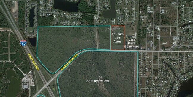
125.54 AC
2025
Charlotte County
2025
Southwest Florida
020101
Punta Gorda, FL
NEARBY LISTINGS FOR SALE OR LEASE
DEMOGRAPHICS near 26800 Harborview Rd
1 mile
3 mile
5 mile
2025 Total Population
3,587
27,896
71,713
2030 Population
3,935
30,746
78,431
Pop Growth 2025-2030
+ 9.70%
+ 10.22%
+ 9.37%
Average Age
49
53
50
2025 Total Households
1,584
12,997
32,450
HH Growth 2025-2030
+ 9.53%
+ 10.26%
+ 9.42%
Median Household Inc
$61,607
$67,688
$64,518
Avg Household Size
2.20
2.10
2.10
2025 Avg HH Vehicles
2.00
2.00
2.00
Median Home Value
$354,166
$323,946
$305,730
Median Year Built
1996
1997
1990
Nearby Places
Map Layers
Map Styles
 Street
 Aerial
Layers
 Traffic
 Biking
Places
Listings with unknown addresses are not visible on the map
- Restaurants
- Banks
- Shops
- Fitness
- Groceries
PUBLIC TRANSPORTATION
AIRPORT
Punta Gorda
Drive
Walk
Distance
Punta Gorda
11 min
6.9 mi
Freight Ports
Port Manatee
Drive
Walk
Distance
Port Manatee
78 min
67.6 mi
SALE & LEASE HISTORY
LISTING DATE
SALE/LEASE

Aug 31, 2022
For Sale
Nearby Properties
Address
Land Use
TOTAL SIZE
Lot Size
Zoning
Address
Land Use
TOTAL SIZE
Lot Size
Zoning
121,585 SF
696.03 AC
RE1
Address
Land Use
TOTAL SIZE
Lot Size
Zoning
249,777 SF
48 AC
RMF10
Address
Land Use
TOTAL SIZE
Lot Size
Zoning
254.31 AC
PD
Address
Land Use
TOTAL SIZE
Lot Size
Zoning
139,109 SF
23.44 AC
CG
Address
Land Use
TOTAL SIZE
Lot Size
Zoning
128,594 SF
25.54 AC
PD
Address
Land Use
TOTAL SIZE
Lot Size
Zoning
83,180 SF
9.31 AC
PD
Address
Land Use
TOTAL SIZE
Lot Size
Zoning
35,951 SF
24.23 AC
PD
Address
Land Use
TOTAL SIZE
Lot Size
Zoning
84,500 SF
5.59 AC
CG
Address
Land Use
TOTAL SIZE
Lot Size
Zoning
86,773 SF
5.07 AC
IG
Address
Land Use
TOTAL SIZE
Lot Size
Zoning
82,865 SF
19.74 AC
RMF12
Address
Land Use
TOTAL SIZE
Lot Size
Zoning
116,186 SF
20.02 AC
RMF10
Address
Land Use
TOTAL SIZE
Lot Size
Zoning
23,798 SF
1.71 AC
PD
Address
Land Use
TOTAL SIZE
Lot Size
Zoning
98,552 SF
11.42 AC
CG
Address
Land Use
TOTAL SIZE
Lot Size
Zoning
66,461 SF
10.86 AC
CG
Address
Land Use
TOTAL SIZE
Lot Size
Zoning
51,248 SF
15.96 AC
PD
Address
Land Use
TOTAL SIZE
Lot Size
Zoning
21.61 AC
PD
Address
Land Use
TOTAL SIZE
Lot Size
Zoning
81,226 SF
11.40 AC
OMI
Address
Land Use
TOTAL SIZE
Lot Size
Zoning
12,977 SF
2.29 AC
PD
Address
Land Use
TOTAL SIZE
Lot Size
Zoning
13,642 SF
2.55 AC
PD
Address
Land Use
TOTAL SIZE
Lot Size
Zoning
34,983 SF
18.79 AC
RE1
Address
Land Use
TOTAL SIZE
Lot Size
Zoning
11,773 SF
1.55 AC
PD
Address
Land Use
TOTAL SIZE
Lot Size
Zoning
7.81 AC
PD
Address
Land Use
TOTAL SIZE
Lot Size
Zoning
60.56 AC
PD
Address
Land Use
TOTAL SIZE
Lot Size
Zoning
73,260 SF
7.68 AC
PD
Address
Land Use
TOTAL SIZE
Lot Size
Zoning
74,434 SF
4.42 AC
CG
Address
Land Use
TOTAL SIZE
Lot Size
Zoning
23,566 SF
20.33 AC
RMF10
Address
Land Use
TOTAL SIZE
Lot Size
Zoning
106.30 AC
PD
Address
Land Use
TOTAL SIZE
Lot Size
Zoning
34,159 SF
23.55 AC
PD
Address
Land Use
TOTAL SIZE
Lot Size
Zoning
32,200 SF
1.99 AC
IG
The World's #1 Commercial Real Estate Marketplace
Connect with us
© 2026 CoStar Group
The information above has been obtained from sources believed reliable. While we do not doubt its accuracy we have not verified it and make no guarantee, warranty or representation about it. It is your responsibility to independently confirm its accuracy and completeness. Any projections, opinions, assumptions, or estimates used are for example only and do not represent the current or future performance of the property. The value of this transaction to you depends on tax and other factors which should be evaluated by your tax, financial, and legal advisors. You and your advisors should conduct a careful, independent investigation of the property to determine to your satisfaction the suitability of the property for your needs.