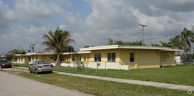
Property Record
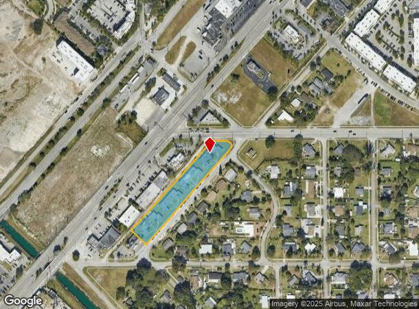
26800 Sw 145Th Avenue Rd, Homestead, FL 33032


NEARBY LISTINGS FOR SALE OR LEASE
Property Detail
26800 Sw 145Th Avenue Rd
Miami-Miami Beach-Kendall, FL
Naranja Park 2Nd Add
30-6933-006-0141
NARANJA PARK 2ND ADD PB 60-67 LOTS 1 THRU 4 BLK 12 LOT SIZE 65410 SQ FT COC 25503-4676 03 2007 2
Multifamilydwelling
Miami/Dade
X
Florida
12086C0593L
1-4
2024
1.50 AC
2025
Outer Homestead/South Dade
010804
South Florida
15,821 SF
DEMOGRAPHICS near 26800 Sw 145Th Avenue Rd
1 Mile
3 Mile
5 Mile
2024 Total Population
18,000
90,851
197,997
2029 Population
17,738
89,366
194,812
Pop Growth 2024-2029
(1.46%)
(1.63%)
(1.61%)
Average Age
35
36
36
2024 Total Households
5,710
26,687
58,248
HH Growth 2024-2029
(1.93%)
(2.06%)
(2.05%)
Median Household Inc
$49,701
$57,930
$60,514
Avg Household Size
3.10
3.30
3.30
2024 Avg HH Vehicles
2.00
2.00
2.00
Median Home Value
$312,200
$309,655
$322,015
Median Year Built
2005
2000
1999
Nearby Places
Map Layers
Map Styles
 Street
 Aerial
- Restaurants
- Banks
- Shops
- Fitness
- Groceries
PUBLIC TRANSPORTATION
AIRPORT
Miami International
DRIVE
WALK
Distance
Miami International
40 min
25.2 mi
Nearby Properties
Address
Land Use
TOTAL SIZE
Lot Size
Zoning
Address
Land Use
TOTAL SIZE
Lot Size
Zoning
487,531 SF
60 AC
9300
Address
Land Use
TOTAL SIZE
Lot Size
Zoning
1,348,296 SF
76.88 AC
7600
Address
Land Use
TOTAL SIZE
Lot Size
Zoning
289,905 SF
29.74 AC
6500
Address
Land Use
TOTAL SIZE
Lot Size
Zoning
321,122 SF
7.31 AC
3161
Address
Land Use
TOTAL SIZE
Lot Size
Zoning
255,576 SF
8.77 AC
6051
Address
Land Use
TOTAL SIZE
Lot Size
Zoning
452,003 SF
10.85 AC
3161
Address
Land Use
TOTAL SIZE
Lot Size
Zoning
313,656 SF
10.71 AC
3900
Address
Land Use
TOTAL SIZE
Lot Size
Zoning
1 SF
20.93 AC
9000
Address
Land Use
TOTAL SIZE
Lot Size
Zoning
180,872 SF
5.85 AC
6262
Address
Land Use
TOTAL SIZE
Lot Size
Zoning
218,945 SF
7.92 AC
7061
Address
Land Use
TOTAL SIZE
Lot Size
Zoning
253,088 SF
2.90 AC
6072
Address
Land Use
TOTAL SIZE
Lot Size
Zoning
225,691 SF
8.22 AC
3900
Address
Land Use
TOTAL SIZE
Lot Size
Zoning
228,908 SF
65.07 AC
3050
Address
Land Use
TOTAL SIZE
Lot Size
Zoning
141,386 SF
9.62 AC
9000
Address
Land Use
TOTAL SIZE
Lot Size
Zoning
183,940 SF
4.80 AC
3050
Address
Land Use
TOTAL SIZE
Lot Size
Zoning
280,512 SF
44.85 AC
7600
Address
Land Use
TOTAL SIZE
Lot Size
Zoning
11,341 SF
212.73 AC
0100
Address
Land Use
TOTAL SIZE
Lot Size
Zoning
302,577 SF
8.04 AC
3050
Address
Land Use
TOTAL SIZE
Lot Size
Zoning
232,810 SF
24.61 AC
3800
Address
Land Use
TOTAL SIZE
Lot Size
Zoning
165,300 SF
10 AC
3050
Address
Land Use
TOTAL SIZE
Lot Size
Zoning
183,633 SF
3.78 AC
3802
Address
Land Use
TOTAL SIZE
Lot Size
Zoning
375,167 SF
22.77 AC
6061
Address
Land Use
TOTAL SIZE
Lot Size
Zoning
199,350 SF
3.75 AC
3161
Address
Land Use
TOTAL SIZE
Lot Size
Zoning
179,608 SF
8.06 AC
9300
Address
Land Use
TOTAL SIZE
Lot Size
Zoning
144,931 SF
10.69 AC
6200
Address
Land Use
TOTAL SIZE
Lot Size
Zoning
119,534 SF
8.55 AC
6200
Address
Land Use
TOTAL SIZE
Lot Size
Zoning
38.67 AC
3700
Address
Land Use
TOTAL SIZE
Lot Size
Zoning
1 SF
365.68 AC
9000
Address
Land Use
TOTAL SIZE
Lot Size
Zoning
159,298 SF
4.93 AC
5300
Address
Land Use
TOTAL SIZE
Lot Size
Zoning
185,907 SF
57.94 AC
3100
The World's #1 Commercial Real Estate Marketplace
Connect with us
© 2025 CoStar Group
The information above has been obtained from sources believed reliable. While we do not doubt its accuracy we have not verified it and make no guarantee, warranty or representation about it. It is your responsibility to independently confirm its accuracy and completeness. Any projections, opinions, assumptions, or estimates used are for example only and do not represent the current or future performance of the property. The value of this transaction to you depends on tax and other factors which should be evaluated by your tax, financial, and legal advisors. You and your advisors should conduct a careful, independent investigation of the property to determine to your satisfaction the suitability of the property for your needs.