Property Record
2681 Hadley Rd, Lapeer, MI 48446
NEARBY LISTINGS FOR SALE OR LEASE
-
-
View all Lapeer listings for sale on LoopNet.com
Property Detail
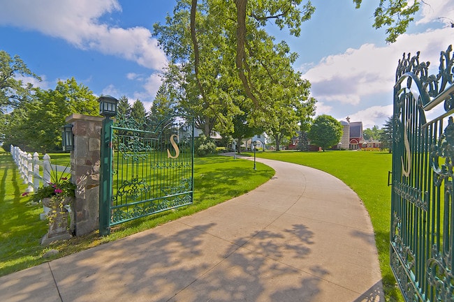
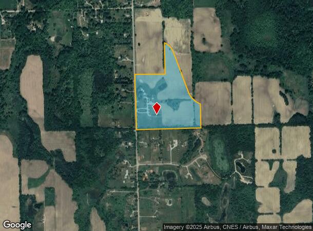
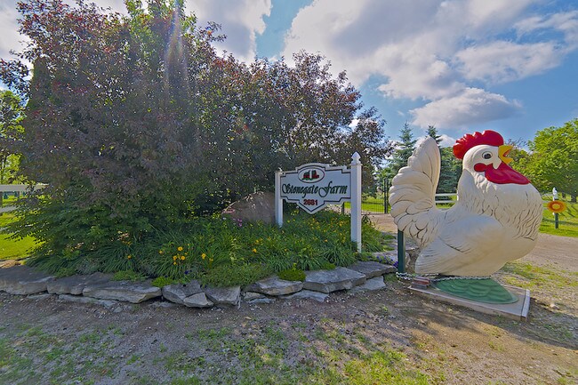
2681 Hadley Rd
008-033-002-01
PARCEL A & B1 COMBINED. PART OF THE NE 1/4 OF SEC 33 T7N R9E ELBA TOWNSHIP LAPEER CNTY MICHIGAN. COMMENCING AT THE N 1/4 CORN
Agriculturalland
Lapeer
X
Michigan
26049C0375D
40.13 AC
2024
St Clair & Lapeer Counties
2025
Detroit
336000
Detroit-Warren-Dearborn, MI
5,497 SF
DEMOGRAPHICS near 2681 Hadley Rd
1 Mile
3 Mile
5 Mile
2024 Total Population
286
4,139
11,590
2029 Population
286
4,148
11,590
Pop Growth 2024-2029
0.00%
+ 0.22%
0.00%
Average Age
45
45
45
2024 Total Households
109
1,587
4,512
HH Growth 2024-2029
0.00%
+ 0.19%
+ 0.07%
Median Household Inc
$90,131
$94,226
$85,187
Avg Household Size
2.50
2.50
2.50
2024 Avg HH Vehicles
2.00
2.00
2.00
Median Home Value
$266,666
$277,377
$261,149
Median Year Built
1975
1976
1976
Nearby Places
Map Layers
Map Styles
 Street
 Aerial
- Restaurants
- Banks
- Shops
- Fitness
- Groceries
PUBLIC TRANSPORTATION
COMMUTER RAIL
Lapeer Amtrak Station (Blue Water - Amtrak)
DRIVE
WALK
Distance
Lapeer Amtrak Station (Blue Water - Amtrak)
19 min
9.3 mi
AIRPORT
Bishop International
DRIVE
WALK
Distance
Bishop International
44 min
26.0 mi
Freight Ports
Port of Toledo
DRIVE
WALK
Distance
Port of Toledo
152 min
106.2 mi
SALE & LEASE HISTORY
LISTING DATE
SALE/LEASE

Jan 15, 2018
For Sale
Nearby Properties
Address
Land Use
TOTAL SIZE
Lot Size
Zoning
Address
Land Use
TOTAL SIZE
Lot Size
Zoning
3,000 SF
58.73 AC
AR
Address
Land Use
TOTAL SIZE
Lot Size
Zoning
3,304 SF
47.13 AC
AR
Address
Land Use
TOTAL SIZE
Lot Size
Zoning
1,316 SF
40 AC
NOT AVAILA
Address
Land Use
TOTAL SIZE
Lot Size
Zoning
3,534 SF
160 AC
RA
Address
Land Use
TOTAL SIZE
Lot Size
Zoning
4,659 SF
34.44 AC
RA
Address
Land Use
TOTAL SIZE
Lot Size
Zoning
8,112 SF
59.60 AC
REC
Address
Land Use
TOTAL SIZE
Lot Size
Zoning
2,875 SF
99.40 AC
RA
Address
Land Use
TOTAL SIZE
Lot Size
Zoning
3,632 SF
75.17 AC
Address
Land Use
TOTAL SIZE
Lot Size
Zoning
2.21 AC
R-1
Address
Land Use
TOTAL SIZE
Lot Size
Zoning
4,078 SF
40 AC
RA
Address
Land Use
TOTAL SIZE
Lot Size
Zoning
2,695 SF
94 AC
RA
Address
Land Use
TOTAL SIZE
Lot Size
Zoning
2,500 SF
73.61 AC
RA
Address
Land Use
TOTAL SIZE
Lot Size
Zoning
33.08 AC
AR
Address
Land Use
TOTAL SIZE
Lot Size
Zoning
80 AC
REC
Address
Land Use
TOTAL SIZE
Lot Size
Zoning
1,872 SF
75.11 AC
AR
Address
Land Use
TOTAL SIZE
Lot Size
Zoning
2,768 SF
10 AC
AR
Address
Land Use
TOTAL SIZE
Lot Size
Zoning
10,640 SF
2.09 AC
Address
Land Use
TOTAL SIZE
Lot Size
Zoning
1,581 SF
143.42 AC
RA
Address
Land Use
TOTAL SIZE
Lot Size
Zoning
1,469 SF
139.72 AC
RA
Address
Land Use
TOTAL SIZE
Lot Size
Zoning
1,236 SF
120 AC
AR
Address
Land Use
TOTAL SIZE
Lot Size
Zoning
1,464 SF
126.62 AC
RA
Address
Land Use
TOTAL SIZE
Lot Size
Zoning
2,760 SF
60 AC
AR
Address
Land Use
TOTAL SIZE
Lot Size
Zoning
2,289 SF
70 AC
AR
Address
Land Use
TOTAL SIZE
Lot Size
Zoning
3,656 SF
10 AC
AR
Address
Land Use
TOTAL SIZE
Lot Size
Zoning
116.09 AC
Address
Land Use
TOTAL SIZE
Lot Size
Zoning
1,992 SF
115.54 AC
RA
Address
Land Use
TOTAL SIZE
Lot Size
Zoning
1,118 SF
70 AC
AR
Address
Land Use
TOTAL SIZE
Lot Size
Zoning
Address
Land Use
TOTAL SIZE
Lot Size
Zoning
3,338 SF
71.76 AC
AR
The World's #1 Commercial Real Estate Marketplace
Connect with us
© 2026 CoStar Group
The information above has been obtained from sources believed reliable. While we do not doubt its accuracy we have not verified it and make no guarantee, warranty or representation about it. It is your responsibility to independently confirm its accuracy and completeness. Any projections, opinions, assumptions, or estimates used are for example only and do not represent the current or future performance of the property. The value of this transaction to you depends on tax and other factors which should be evaluated by your tax, financial, and legal advisors. You and your advisors should conduct a careful, independent investigation of the property to determine to your satisfaction the suitability of the property for your needs.