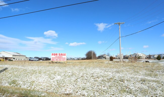
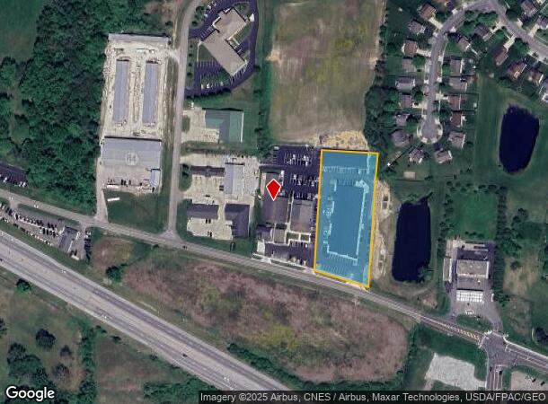
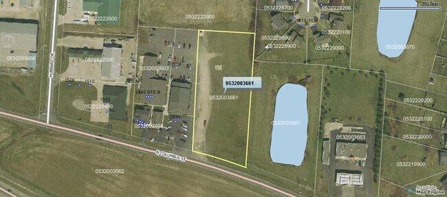
Property Record
2682 N Columbus St, Lancaster, OH 43130
NEARBY LISTINGS FOR SALE OR LEASE
Property Detail
2682 N Columbus St
05-32003-661
R 19 T 15 S 27 NE ANNXD 6/25/92
Officebuilding
Fairfield
X
Ohio
39045C0232G
1.83 AC
2024
Fairfield County
2024
Columbus
030901
Columbus, OH
26,700 SF
DEMOGRAPHICS near 2682 N Columbus St
1 Mile
3 Mile
5 Mile
2024 Total Population
6,210
28,455
56,241
2029 Population
6,747
30,713
60,497
Pop Growth 2024-2029
+ 8.65%
+ 7.94%
+ 7.57%
Average Age
39
41
41
2024 Total Households
2,584
11,815
22,811
HH Growth 2024-2029
+ 9.48%
+ 8.26%
+ 7.83%
Median Household Inc
$71,087
$58,826
$61,022
Avg Household Size
2.40
2.30
2.30
2024 Avg HH Vehicles
2.00
2.00
2.00
Median Home Value
$216,378
$166,473
$185,144
Median Year Built
2000
1971
1968
Nearby Places
Map Layers
Map Styles
 Street
 Aerial
- Restaurants
- Banks
- Shops
- Fitness
- Groceries
PUBLIC TRANSPORTATION
AIRPORT
Rickenbacker International
DRIVE
WALK
Distance
Rickenbacker International
35 min
20.6 mi
John Glenn Columbus International
DRIVE
WALK
Distance
John Glenn Columbus International
41 min
27.6 mi
SALE & LEASE HISTORY
LISTING DATE
SALE/LEASE

Dec 04, 2019
For Sale
Nearby Properties
Address
Land Use
TOTAL SIZE
Lot Size
Zoning
Address
Land Use
TOTAL SIZE
Lot Size
Zoning
1,278,248 SF
65.57 AC
Address
Land Use
TOTAL SIZE
Lot Size
Zoning
287,864 SF
121.55 AC
Address
Land Use
TOTAL SIZE
Lot Size
Zoning
111,535 SF
4.80 AC
Address
Land Use
TOTAL SIZE
Lot Size
Zoning
85,331 SF
18.94 AC
Address
Land Use
TOTAL SIZE
Lot Size
Zoning
44,800 SF
15.93 AC
Address
Land Use
TOTAL SIZE
Lot Size
Zoning
69,461 SF
13.72 AC
Address
Land Use
TOTAL SIZE
Lot Size
Zoning
45,633 SF
13.92 AC
Address
Land Use
TOTAL SIZE
Lot Size
Zoning
330,207 SF
17.97 AC
Address
Land Use
TOTAL SIZE
Lot Size
Zoning
88,522 SF
37.42 AC
Address
Land Use
TOTAL SIZE
Lot Size
Zoning
330,207 SF
17.97 AC
Address
Land Use
TOTAL SIZE
Lot Size
Zoning
67,322 SF
16.45 AC
Address
Land Use
TOTAL SIZE
Lot Size
Zoning
56,826 SF
7.04 AC
Address
Land Use
TOTAL SIZE
Lot Size
Zoning
130,341 SF
43.19 AC
Address
Land Use
TOTAL SIZE
Lot Size
Zoning
62,550 SF
14.82 AC
Address
Land Use
TOTAL SIZE
Lot Size
Zoning
155,985 SF
13.70 AC
Address
Land Use
TOTAL SIZE
Lot Size
Zoning
229,660 SF
21.76 AC
Address
Land Use
TOTAL SIZE
Lot Size
Zoning
76,509 SF
7.21 AC
Address
Land Use
TOTAL SIZE
Lot Size
Zoning
34,020 SF
20.93 AC
Address
Land Use
TOTAL SIZE
Lot Size
Zoning
144,184 SF
42.05 AC
Address
Land Use
TOTAL SIZE
Lot Size
Zoning
177,448 SF
16.40 AC
Address
Land Use
TOTAL SIZE
Lot Size
Zoning
152,995 SF
15.54 AC
Address
Land Use
TOTAL SIZE
Lot Size
Zoning
201,304 SF
17.11 AC
Address
Land Use
TOTAL SIZE
Lot Size
Zoning
126,928 SF
12.29 AC
Address
Land Use
TOTAL SIZE
Lot Size
Zoning
59,538 SF
22.24 AC
Address
Land Use
TOTAL SIZE
Lot Size
Zoning
573,376 SF
51.48 AC
Address
Land Use
TOTAL SIZE
Lot Size
Zoning
149,903 SF
43.98 AC
Address
Land Use
TOTAL SIZE
Lot Size
Zoning
63,618 SF
4.14 AC
Address
Land Use
TOTAL SIZE
Lot Size
Zoning
91,283 SF
9.73 AC
Address
Land Use
TOTAL SIZE
Lot Size
Zoning
82,876 SF
7.71 AC
Address
Land Use
TOTAL SIZE
Lot Size
Zoning
40,279 SF
9.33 AC
The World's #1 Commercial Real Estate Marketplace
Connect with us
© 2025 CoStar Group
The information above has been obtained from sources believed reliable. While we do not doubt its accuracy we have not verified it and make no guarantee, warranty or representation about it. It is your responsibility to independently confirm its accuracy and completeness. Any projections, opinions, assumptions, or estimates used are for example only and do not represent the current or future performance of the property. The value of this transaction to you depends on tax and other factors which should be evaluated by your tax, financial, and legal advisors. You and your advisors should conduct a careful, independent investigation of the property to determine to your satisfaction the suitability of the property for your needs.