Property Record
2684 Alcoa Hwy, Alcoa, TN 37701
NEARBY LISTINGS FOR SALE OR LEASE
Property Detail
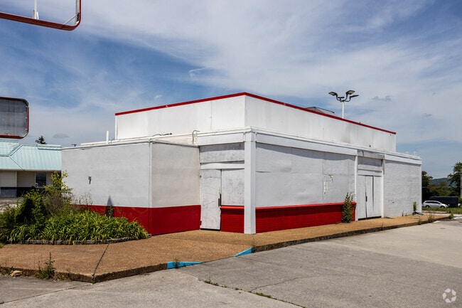
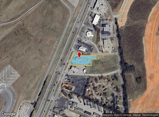
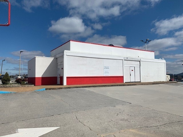
2684 Alcoa Hwy
026E-A-013.00
1097A KRYSTAL
Restaurantdrivein
Blount
X
Tennessee
47009C0128C
0.83 AC
0
Blount County
2025
Knoxville
010302
Knoxville, TN
2,362 SF
DEMOGRAPHICS near 2684 Alcoa Hwy
1 Mile
3 Mile
5 Mile
2024 Total Population
405
19,523
53,069
2029 Population
443
21,231
57,652
Pop Growth 2024-2029
+ 9.38%
+ 8.75%
+ 8.64%
Average Age
40
41
41
2024 Total Households
174
8,216
21,761
HH Growth 2024-2029
+ 9.20%
+ 8.75%
+ 8.69%
Median Household Inc
$36,944
$57,745
$57,762
Avg Household Size
2.30
2.30
2.30
2024 Avg HH Vehicles
2.00
2.00
2.00
Median Home Value
$85,848
$187,222
$215,037
Median Year Built
1978
1976
1978
Nearby Places
Map Layers
Map Styles
 Street
 Aerial
- Restaurants
- Banks
- Shops
- Fitness
- Groceries
PUBLIC TRANSPORTATION
AIRPORT
McGhee Tyson
DRIVE
WALK
Distance
McGhee Tyson
7 min
2.9 mi
SALE & LEASE HISTORY
LISTING DATE
SALE/LEASE

Jun 20, 2017
For Sale
Jun 13, 2018
For Sale
Dec 12, 2019
For Lease
Apr 04, 2020
For Lease
Nearby Properties
Address
Land Use
TOTAL SIZE
Lot Size
Zoning
Address
Land Use
TOTAL SIZE
Lot Size
Zoning
2,612,320 SF
84.53 AC
S
Address
Land Use
TOTAL SIZE
Lot Size
Zoning
1,401.64 AC
AIR
Address
Land Use
TOTAL SIZE
Lot Size
Zoning
635,728 SF
234.46 AC
I
Address
Land Use
TOTAL SIZE
Lot Size
Zoning
222.60 AC
G
Address
Land Use
TOTAL SIZE
Lot Size
Zoning
29,040 SF
8.91 AC
G
Address
Land Use
TOTAL SIZE
Lot Size
Zoning
46.37 AC
AIR
Address
Land Use
TOTAL SIZE
Lot Size
Zoning
144,298 SF
4.51 AC
G
Address
Land Use
TOTAL SIZE
Lot Size
Zoning
52,476 SF
20.82 AC
S
Address
Land Use
TOTAL SIZE
Lot Size
Zoning
150,532 SF
5.41 AC
G
Address
Land Use
TOTAL SIZE
Lot Size
Zoning
477.90 AC
I
Address
Land Use
TOTAL SIZE
Lot Size
Zoning
29,765 SF
14.67 AC
E
Address
Land Use
TOTAL SIZE
Lot Size
Zoning
64,033 SF
5.65 AC
O-3
Address
Land Use
TOTAL SIZE
Lot Size
Zoning
258,532 SF
20 AC
O3
Address
Land Use
TOTAL SIZE
Lot Size
Zoning
18,936 SF
19.66 AC
I
Address
Land Use
TOTAL SIZE
Lot Size
Zoning
9,040 SF
27.85 AC
OS
Address
Land Use
TOTAL SIZE
Lot Size
Zoning
15,340 SF
5 AC
F
Address
Land Use
TOTAL SIZE
Lot Size
Zoning
86.20 AC
F
Address
Land Use
TOTAL SIZE
Lot Size
Zoning
60,328 SF
4.41 AC
F
Address
Land Use
TOTAL SIZE
Lot Size
Zoning
96,738 SF
23.34 AC
F
Address
Land Use
TOTAL SIZE
Lot Size
Zoning
175,681 SF
AIR
Address
Land Use
TOTAL SIZE
Lot Size
Zoning
68,180 SF
35.92 AC
AIR
Address
Land Use
TOTAL SIZE
Lot Size
Zoning
53,524 SF
6.95 AC
C
Address
Land Use
TOTAL SIZE
Lot Size
Zoning
48,590 SF
16.67 AC
G
Address
Land Use
TOTAL SIZE
Lot Size
Zoning
215,478 SF
29.02 AC
F
Address
Land Use
TOTAL SIZE
Lot Size
Zoning
63,292 SF
2.03 AC
G
Address
Land Use
TOTAL SIZE
Lot Size
Zoning
4,510 SF
13.72 AC
B
Address
Land Use
TOTAL SIZE
Lot Size
Zoning
57,988 SF
7.18 AC
G
Address
Land Use
TOTAL SIZE
Lot Size
Zoning
6,048 SF
14.76 AC
S
Address
Land Use
TOTAL SIZE
Lot Size
Zoning
48,216 SF
2.26 AC
G
Address
Land Use
TOTAL SIZE
Lot Size
Zoning
23,254 SF
2.37 AC
O3
The World's #1 Commercial Real Estate Marketplace
Connect with us
© 2025 CoStar Group
The information above has been obtained from sources believed reliable. While we do not doubt its accuracy we have not verified it and make no guarantee, warranty or representation about it. It is your responsibility to independently confirm its accuracy and completeness. Any projections, opinions, assumptions, or estimates used are for example only and do not represent the current or future performance of the property. The value of this transaction to you depends on tax and other factors which should be evaluated by your tax, financial, and legal advisors. You and your advisors should conduct a careful, independent investigation of the property to determine to your satisfaction the suitability of the property for your needs.