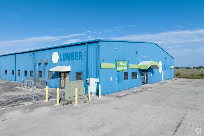
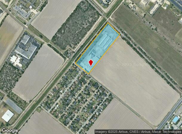
Property Record
2684 Shafer Rd, San Benito, TX 78586

NEARBY LISTINGS FOR SALE OR LEASE
Property Detail
2684 Shafer Rd
Brownsville-Harlingen, TX
84 Lumber Company Subdivision
885260-0010-001000
LOT 1 BLK 1 84 LUMBER COMPANY SUBDIVISION
Commercialnec
Cameron
X
Texas
48061C0270F
1
2024
10.70 AC
2025
Greater Harlingen
011701
Brownsville/Harlingen
33,550 SF
DEMOGRAPHICS near 2684 Shafer Rd
1 Mile
3 Mile
5 Mile
2024 Total Population
4,658
48,450
94,732
2029 Population
4,666
49,801
97,078
Pop Growth 2024-2029
+ 0.17%
+ 2.79%
+ 2.48%
Average Age
39
37
37
2024 Total Households
1,726
16,625
31,904
HH Growth 2024-2029
+ 0.23%
+ 2.72%
+ 2.40%
Median Household Inc
$36,268
$42,103
$45,169
Avg Household Size
2.50
2.80
2.80
2024 Avg HH Vehicles
1.00
2.00
2.00
Median Home Value
$97,138
$85,379
$90,094
Median Year Built
1988
1984
1984
Nearby Places
Map Layers
Map Styles
 Street
 Aerial
- Restaurants
- Banks
- Shops
- Fitness
- Groceries
PUBLIC TRANSPORTATION
AIRPORT
Valley International
DRIVE
WALK
Distance
Valley International
12 min
6.4 mi
Brownsville/South Padre Island International
DRIVE
WALK
Distance
Brownsville/South Padre Island International
34 min
25.0 mi
Freight Ports
Port of Brownsville
DRIVE
WALK
Distance
Port of Brownsville
27 min
22.6 mi
SALE & LEASE HISTORY
LISTING DATE
SALE/LEASE

Sep 24, 2016
For Sale
Oct 28, 2017
For Sale
Jun 15, 2018
For Lease
Jul 11, 2017
For Sale
Aug 25, 2017
For Sale
Nearby Properties
Address
Land Use
TOTAL SIZE
Lot Size
Zoning
Address
Land Use
TOTAL SIZE
Lot Size
Zoning
758,640 SF
11.31 AC
Address
Land Use
TOTAL SIZE
Lot Size
Zoning
427,448 SF
6.94 AC
Address
Land Use
TOTAL SIZE
Lot Size
Zoning
89,797 SF
7.90 AC
Address
Land Use
TOTAL SIZE
Lot Size
Zoning
186,716 SF
13.31 AC
C
Address
Land Use
TOTAL SIZE
Lot Size
Zoning
663,572 SF
60.74 AC
I
Address
Land Use
TOTAL SIZE
Lot Size
Zoning
159,787 SF
10.66 AC
Address
Land Use
TOTAL SIZE
Lot Size
Zoning
148,596 SF
1 AC
Address
Land Use
TOTAL SIZE
Lot Size
Zoning
134,518 SF
10.01 AC
Address
Land Use
TOTAL SIZE
Lot Size
Zoning
118,561 SF
6.32 AC
C
Address
Land Use
TOTAL SIZE
Lot Size
Zoning
77,189 SF
3.28 AC
Address
Land Use
TOTAL SIZE
Lot Size
Zoning
62,764 SF
10 AC
Address
Land Use
TOTAL SIZE
Lot Size
Zoning
61,920 SF
5.60 AC
C
Address
Land Use
TOTAL SIZE
Lot Size
Zoning
155,425 SF
20.77 AC
C
Address
Land Use
TOTAL SIZE
Lot Size
Zoning
1,152 SF
44.60 AC
C
Address
Land Use
TOTAL SIZE
Lot Size
Zoning
138,862 SF
15.82 AC
Address
Land Use
TOTAL SIZE
Lot Size
Zoning
206,973 SF
12.77 AC
Address
Land Use
TOTAL SIZE
Lot Size
Zoning
230,267 SF
7.85 AC
C
Address
Land Use
TOTAL SIZE
Lot Size
Zoning
76,722 SF
8.26 AC
Address
Land Use
TOTAL SIZE
Lot Size
Zoning
180,838 SF
12.56 AC
C
Address
Land Use
TOTAL SIZE
Lot Size
Zoning
78,223 SF
20.85 AC
Address
Land Use
TOTAL SIZE
Lot Size
Zoning
47,558 SF
7 AC
Address
Land Use
TOTAL SIZE
Lot Size
Zoning
90,376 SF
1.93 AC
Address
Land Use
TOTAL SIZE
Lot Size
Zoning
176,627 SF
12.45 AC
A-C
Address
Land Use
TOTAL SIZE
Lot Size
Zoning
42,557 SF
1.74 AC
C
Address
Land Use
TOTAL SIZE
Lot Size
Zoning
145,232 SF
6.38 AC
Address
Land Use
TOTAL SIZE
Lot Size
Zoning
84,936 SF
12 AC
Address
Land Use
TOTAL SIZE
Lot Size
Zoning
108,000 SF
10.44 AC
C
Address
Land Use
TOTAL SIZE
Lot Size
Zoning
93,459 SF
20 AC
Address
Land Use
TOTAL SIZE
Lot Size
Zoning
54,605 SF
25.70 AC
A-C
Address
Land Use
TOTAL SIZE
Lot Size
Zoning
55,573 SF
20 AC
C
The World's #1 Commercial Real Estate Marketplace
Connect with us
© 2025 CoStar Group
The information above has been obtained from sources believed reliable. While we do not doubt its accuracy we have not verified it and make no guarantee, warranty or representation about it. It is your responsibility to independently confirm its accuracy and completeness. Any projections, opinions, assumptions, or estimates used are for example only and do not represent the current or future performance of the property. The value of this transaction to you depends on tax and other factors which should be evaluated by your tax, financial, and legal advisors. You and your advisors should conduct a careful, independent investigation of the property to determine to your satisfaction the suitability of the property for your needs.