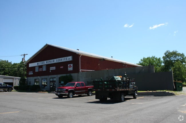
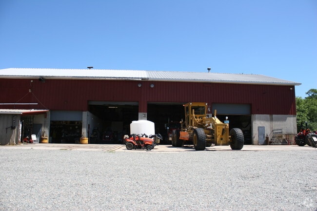
Property Record
269 Dedham St, Norfolk, MA 02056

NEARBY LISTINGS FOR SALE OR LEASE
Property Detail
269 Dedham St
NORF-000018-000082-000010
Norfolk
Autorepair
Massachusetts
AE
10
25021C0333F
1.26 AC
2025
I-95 Corridor South
2025
Boston
409101
Boston-Cambridge-Newton, MA-NH
8,712 SF
DEMOGRAPHICS near 269 Dedham St
1 Mile
3 Mile
5 Mile
2024 Total Population
1,338
20,859
67,280
2029 Population
1,338
20,784
67,156
Pop Growth 2024-2029
0.00%
(0.36%)
(0.18%)
Average Age
41
42
41
2024 Total Households
483
7,417
24,893
HH Growth 2024-2029
0.00%
(0.38%)
(0.20%)
Median Household Inc
$123,528
$139,068
$126,428
Avg Household Size
2.70
2.70
2.60
2024 Avg HH Vehicles
2.00
2.00
2.00
Median Home Value
$533,186
$621,428
$608,901
Median Year Built
1973
1977
1979
Nearby Places
Map Layers
Map Styles
 Street
 Aerial
- Restaurants
- Banks
- Shops
- Fitness
- Groceries
SALE & LEASE HISTORY
LISTING DATE
SALE/LEASE

Nov 27, 2018
For Lease
Nov 27, 2018
For Sale
Nov 03, 2016
For Lease
Nov 03, 2016
For Sale
Nearby Properties
Address
Land Use
TOTAL SIZE
Lot Size
Zoning
Address
Land Use
TOTAL SIZE
Lot Size
Zoning
Address
Land Use
TOTAL SIZE
Lot Size
Zoning
14,317 SF
411.17 AC
R-43
Address
Land Use
TOTAL SIZE
Lot Size
Zoning
231,487 SF
33.15 AC
R-30
Address
Land Use
TOTAL SIZE
Lot Size
Zoning
19,742 SF
58.34 AC
R-43
Address
Land Use
TOTAL SIZE
Lot Size
Zoning
99,952 SF
19.80 AC
Address
Land Use
TOTAL SIZE
Lot Size
Zoning
41.28 AC
Address
Land Use
TOTAL SIZE
Lot Size
Zoning
83,014 SF
129.67 AC
Address
Land Use
TOTAL SIZE
Lot Size
Zoning
126,484 SF
1.61 AC
Address
Land Use
TOTAL SIZE
Lot Size
Zoning
125,778 SF
35.60 AC
Address
Land Use
TOTAL SIZE
Lot Size
Zoning
59,390 SF
5.69 AC
Address
Land Use
TOTAL SIZE
Lot Size
Zoning
814.08 AC
Address
Land Use
TOTAL SIZE
Lot Size
Zoning
57,305 SF
24.84 AC
Address
Land Use
TOTAL SIZE
Lot Size
Zoning
7.86 AC
Address
Land Use
TOTAL SIZE
Lot Size
Zoning
3,024 SF
12.47 AC
C-1 80
Address
Land Use
TOTAL SIZE
Lot Size
Zoning
202,800 SF
20.33 AC
Address
Land Use
TOTAL SIZE
Lot Size
Zoning
11.97 AC
Address
Land Use
TOTAL SIZE
Lot Size
Zoning
10,984 SF
8.52 AC
B-1 10
Address
Land Use
TOTAL SIZE
Lot Size
Zoning
132,952 SF
13.64 AC
Address
Land Use
TOTAL SIZE
Lot Size
Zoning
91,216 SF
1.18 AC
Address
Land Use
TOTAL SIZE
Lot Size
Zoning
117,428 SF
2.81 AC
Address
Land Use
TOTAL SIZE
Lot Size
Zoning
38.97 AC
Address
Land Use
TOTAL SIZE
Lot Size
Zoning
4.13 AC
Address
Land Use
TOTAL SIZE
Lot Size
Zoning
1,536 SF
63.73 AC
Address
Land Use
TOTAL SIZE
Lot Size
Zoning
117,777 SF
2.97 AC
Address
Land Use
TOTAL SIZE
Lot Size
Zoning
5.05 AC
Address
Land Use
TOTAL SIZE
Lot Size
Zoning
95,260 SF
12.80 AC
Address
Land Use
TOTAL SIZE
Lot Size
Zoning
47.53 AC
Address
Land Use
TOTAL SIZE
Lot Size
Zoning
130,854 SF
11.79 AC
C-1 80
Address
Land Use
TOTAL SIZE
Lot Size
Zoning
58,549 SF
5.82 AC
Address
Land Use
TOTAL SIZE
Lot Size
Zoning
6.13 AC
The World's #1 Commercial Real Estate Marketplace
Connect with us
© 2025 CoStar Group
The information above has been obtained from sources believed reliable. While we do not doubt its accuracy we have not verified it and make no guarantee, warranty or representation about it. It is your responsibility to independently confirm its accuracy and completeness. Any projections, opinions, assumptions, or estimates used are for example only and do not represent the current or future performance of the property. The value of this transaction to you depends on tax and other factors which should be evaluated by your tax, financial, and legal advisors. You and your advisors should conduct a careful, independent investigation of the property to determine to your satisfaction the suitability of the property for your needs.