Property Record
269 St Simons Way, Deatsville, AL 36022
NEARBY LISTINGS FOR SALE OR LEASE
-
-
View all Deatsville listings for sale on LoopNet.com
Property Detail
269 St Simons Way
Commercialbuilding
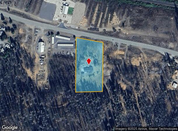
Parcel Map For Jan Len Inc
D
Plumas
06035C2400D
California
2024
3.38 AC
2025
California North Rural Area
000400
Other Market Areas
2,423 SF
110-360-009-000
DEMOGRAPHICS near 269 St Simons Way
1 Mile
3 Mile
5 Mile
2024 Total Population
451
934
1,264
2029 Population
396
836
1,145
Pop Growth 2024-2029
(12.20%)
(10.49%)
(9.41%)
Average Age
44
45
46
2024 Total Households
213
442
594
HH Growth 2024-2029
(12.68%)
(10.86%)
(9.76%)
Median Household Inc
$29,078
$32,083
$40,536
Avg Household Size
2.10
2.10
2.10
2024 Avg HH Vehicles
2.00
2.00
2.00
Median Home Value
$274,999
$288,749
$276,086
Median Year Built
1957
1962
1967
Nearby Places
Map Layers
Map Styles
 Street
 Aerial
- Restaurants
- Banks
- Shops
- Fitness
- Groceries
Nearby Properties
Address
Land Use
TOTAL SIZE
Lot Size
Zoning
Address
Land Use
TOTAL SIZE
Lot Size
Zoning
13,296 SF
3.27 AC
Address
Land Use
TOTAL SIZE
Lot Size
Zoning
8,839 SF
0.84 AC
C1
Address
Land Use
TOTAL SIZE
Lot Size
Zoning
11.74 AC
C-2
Address
Land Use
TOTAL SIZE
Lot Size
Zoning
3,528 SF
95 AC
S3
Address
Land Use
TOTAL SIZE
Lot Size
Zoning
1,356 SF
0.28 AC
C-1
Address
Land Use
TOTAL SIZE
Lot Size
Zoning
35,884 SF
4.45 AC
I1 C2
Address
Land Use
TOTAL SIZE
Lot Size
Zoning
20.41 AC
S-3
Address
Land Use
TOTAL SIZE
Lot Size
Zoning
450 SF
140 AC
R-10
Address
Land Use
TOTAL SIZE
Lot Size
Zoning
510 SF
2.72 AC
S-3
Address
Land Use
TOTAL SIZE
Lot Size
Zoning
7,600 SF
3.64 AC
I-2
Address
Land Use
TOTAL SIZE
Lot Size
Zoning
1,548 SF
0.24 AC
C-1
Address
Land Use
TOTAL SIZE
Lot Size
Zoning
7,296 SF
37.44 AC
I-2
Address
Land Use
TOTAL SIZE
Lot Size
Zoning
168 SF
92.52 AC
S-3,I-1
Address
Land Use
TOTAL SIZE
Lot Size
Zoning
3,200 SF
1.42 AC
2R
Address
Land Use
TOTAL SIZE
Lot Size
Zoning
6,207 SF
1.15 AC
C-2
Address
Land Use
TOTAL SIZE
Lot Size
Zoning
3,546 SF
10.41 AC
S-3
Address
Land Use
TOTAL SIZE
Lot Size
Zoning
5,120 SF
0.46 AC
C-2,C-1
Address
Land Use
TOTAL SIZE
Lot Size
Zoning
99.18 AC
AP,TPZ
Address
Land Use
TOTAL SIZE
Lot Size
Zoning
4,416 SF
0.22 AC
7R
Address
Land Use
TOTAL SIZE
Lot Size
Zoning
Address
Land Use
TOTAL SIZE
Lot Size
Zoning
4,095 SF
13 AC
S-3
Address
Land Use
TOTAL SIZE
Lot Size
Zoning
1,900 SF
3.06 AC
S-1
Address
Land Use
TOTAL SIZE
Lot Size
Zoning
1,830 SF
0.31 AC
C-1
Address
Land Use
TOTAL SIZE
Lot Size
Zoning
15,641 SF
11.79 AC
AP
Address
Land Use
TOTAL SIZE
Lot Size
Zoning
59,988 SF
2.59 AC
I1
Address
Land Use
TOTAL SIZE
Lot Size
Zoning
9,792 SF
29.63 AC
I-1
Address
Land Use
TOTAL SIZE
Lot Size
Zoning
6,816 SF
2.46 AC
C-2
Address
Land Use
TOTAL SIZE
Lot Size
Zoning
2,838 SF
0.26 AC
C-1
Address
Land Use
TOTAL SIZE
Lot Size
Zoning
5,019 SF
0.28 AC
C-2
Address
Land Use
TOTAL SIZE
Lot Size
Zoning
256.93 AC
AP
The World's #1 Commercial Real Estate Marketplace
Connect with us
© 2026 CoStar Group
The information above has been obtained from sources believed reliable. While we do not doubt its accuracy we have not verified it and make no guarantee, warranty or representation about it. It is your responsibility to independently confirm its accuracy and completeness. Any projections, opinions, assumptions, or estimates used are for example only and do not represent the current or future performance of the property. The value of this transaction to you depends on tax and other factors which should be evaluated by your tax, financial, and legal advisors. You and your advisors should conduct a careful, independent investigation of the property to determine to your satisfaction the suitability of the property for your needs.