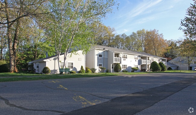
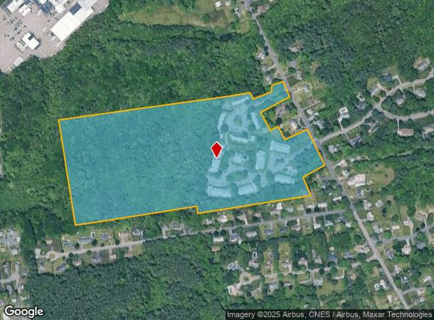
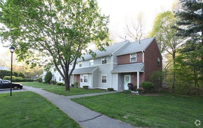
Property Record
269 Stony Hill Rd, Wilbraham, MA 01095
NEARBY LISTINGS FOR SALE OR LEASE
-
-
View all Wilbraham listings for sale on LoopNet.com
Property Detail
269 Stony Hill Rd
WILB-011150-000225-004803
Hampden
Apartment
Massachusetts
X
4803
25013C0240E
38.61 AC
2025
East Hampden County
2025
Hartford
813601
Springfield, MA
3,534 SF
DEMOGRAPHICS near 269 Stony Hill Rd
1 Mile
3 Mile
5 Mile
2024 Total Population
6,665
55,686
120,444
2029 Population
6,601
54,935
118,661
Pop Growth 2024-2029
(0.96%)
(1.35%)
(1.48%)
Average Age
43
41
41
2024 Total Households
2,787
21,892
45,570
HH Growth 2024-2029
(1.00%)
(1.42%)
(1.54%)
Median Household Inc
$75,456
$65,236
$67,033
Avg Household Size
2.40
2.40
2.50
2024 Avg HH Vehicles
2.00
2.00
2.00
Median Home Value
$265,542
$248,980
$243,342
Median Year Built
1963
1960
1958
Nearby Places
Map Layers
Map Styles
 Street
 Aerial
- Restaurants
- Banks
- Shops
- Fitness
- Groceries
PUBLIC TRANSPORTATION
COMMUTER RAIL
Springfield (Amtrak Hartford Line - Amtrak, Hartford Line - Amtrak, Lake Shore Limited - Amtrak, Northeast Regional - Amtrak, Valley Flyer - Amtrak, Vermonter - Amtrak)
DRIVE
WALK
Distance
Springfield (Amtrak Hartford Line - Amtrak, Hartford Line - Amtrak, Lake Shore Limited - Amtrak, Northeast Regional - Amtrak, Valley Flyer - Amtrak, Vermonter - Amtrak)
15 min
7.9 mi
AIRPORT
Bradley International
DRIVE
WALK
Distance
Bradley International
46 min
21.3 mi
Freight Ports
Port of New Haven
DRIVE
WALK
Distance
Port of New Haven
96 min
71.6 mi
Nearby Properties
Address
Land Use
TOTAL SIZE
Lot Size
Zoning
Address
Land Use
TOTAL SIZE
Lot Size
Zoning
89,312 SF
38.72 AC
R1
Address
Land Use
TOTAL SIZE
Lot Size
Zoning
248,182 SF
46.27 AC
R34
Address
Land Use
TOTAL SIZE
Lot Size
Zoning
56,576 SF
62.84 AC
SR1R4
Address
Land Use
TOTAL SIZE
Lot Size
Zoning
7.41 AC
I2
Address
Land Use
TOTAL SIZE
Lot Size
Zoning
45,444 SF
13.80 AC
Address
Land Use
TOTAL SIZE
Lot Size
Zoning
131,942 SF
40.30 AC
R1
Address
Land Use
TOTAL SIZE
Lot Size
Zoning
60.25 AC
Address
Land Use
TOTAL SIZE
Lot Size
Zoning
39,776 SF
8.16 AC
R2
Address
Land Use
TOTAL SIZE
Lot Size
Zoning
102,932 SF
60.01 AC
R6
Address
Land Use
TOTAL SIZE
Lot Size
Zoning
94,076 SF
63.12 AC
Address
Land Use
TOTAL SIZE
Lot Size
Zoning
105,000 SF
17.59 AC
SR1R3
Address
Land Use
TOTAL SIZE
Lot Size
Zoning
71,911 SF
9.19 AC
Address
Land Use
TOTAL SIZE
Lot Size
Zoning
762,340 SF
76.18 AC
SR1R2I
Address
Land Use
TOTAL SIZE
Lot Size
Zoning
28.31 AC
Address
Land Use
TOTAL SIZE
Lot Size
Zoning
99,792 SF
123.26 AC
S
Address
Land Use
TOTAL SIZE
Lot Size
Zoning
79.26 AC
R-2
Address
Land Use
TOTAL SIZE
Lot Size
Zoning
62,115 SF
1.69 AC
R1
Address
Land Use
TOTAL SIZE
Lot Size
Zoning
136,326 SF
65.19 AC
Address
Land Use
TOTAL SIZE
Lot Size
Zoning
15.31 AC
GB
Address
Land Use
TOTAL SIZE
Lot Size
Zoning
6.81 AC
S
Address
Land Use
TOTAL SIZE
Lot Size
Zoning
49,431 SF
6.19 AC
SR1B1
Address
Land Use
TOTAL SIZE
Lot Size
Zoning
34,732 SF
24.73 AC
R1
Address
Land Use
TOTAL SIZE
Lot Size
Zoning
47,458 SF
3.87 AC
R1
Address
Land Use
TOTAL SIZE
Lot Size
Zoning
139,292 SF
12.54 AC
SB1I2
Address
Land Use
TOTAL SIZE
Lot Size
Zoning
34.44 AC
I
Address
Land Use
TOTAL SIZE
Lot Size
Zoning
144,253 SF
32.19 AC
SR2B1
Address
Land Use
TOTAL SIZE
Lot Size
Zoning
13.02 AC
Address
Land Use
TOTAL SIZE
Lot Size
Zoning
42,600 SF
10.09 AC
R1
Address
Land Use
TOTAL SIZE
Lot Size
Zoning
133,600 SF
23.27 AC
R3
The World's #1 Commercial Real Estate Marketplace
Connect with us
© 2025 CoStar Group
The information above has been obtained from sources believed reliable. While we do not doubt its accuracy we have not verified it and make no guarantee, warranty or representation about it. It is your responsibility to independently confirm its accuracy and completeness. Any projections, opinions, assumptions, or estimates used are for example only and do not represent the current or future performance of the property. The value of this transaction to you depends on tax and other factors which should be evaluated by your tax, financial, and legal advisors. You and your advisors should conduct a careful, independent investigation of the property to determine to your satisfaction the suitability of the property for your needs.