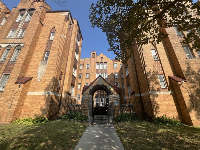
Property Record
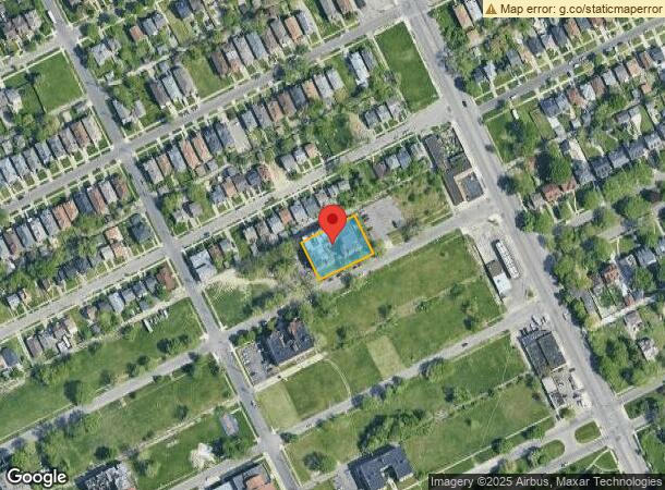
2690 W Boston Blvd, Detroit, MI 48206

NEARBY LISTINGS FOR SALE OR LEASE
Property Detail
2690 W Boston Blvd
10-002798
Hamlin & Fordyces Grand River Ave
Retirementnursinghomecombined
N BOSTON AVE 16 THRU 13 PEARSONS BOSTON BLVD SUB L33 P16 PLATS, W C R 10/104 160 X 111
X
Wayne
26163C0125E
Michigan
2024
0.41 AC
2025
North Detroit
531100
Detroit
42,504 SF
Detroit-Warren-Dearborn, MI
DEMOGRAPHICS near 2690 W Boston Blvd
1 Mile
3 Mile
5 Mile
2024 Total Population
22,625
149,276
418,201
2029 Population
23,535
151,825
415,392
Pop Growth 2024-2029
+ 4.02%
+ 1.71%
(0.67%)
Average Age
39
38
37
2024 Total Households
9,609
62,066
162,424
HH Growth 2024-2029
+ 4.13%
+ 1.83%
(0.38%)
Median Household Inc
$30,273
$31,827
$35,848
Avg Household Size
2.30
2.30
2.40
2024 Avg HH Vehicles
1.00
1.00
1.00
Median Home Value
$96,125
$84,022
$88,773
Median Year Built
1946
1947
1948
Nearby Places
Map Layers
Map Styles
 Street
 Aerial
- Restaurants
- Banks
- Shops
- Fitness
- Groceries
PUBLIC TRANSPORTATION
AIRPORT
Detroit City
DRIVE
WALK
Distance
Detroit City
18 min
8.8 mi
Detroit Metro Wayne County
DRIVE
WALK
Distance
Detroit Metro Wayne County
32 min
26.1 mi
Freight Ports
Port of Baltimore
DRIVE
WALK
Distance
Port of Baltimore
1 min
402.8 mi
SALE & LEASE HISTORY
LISTING DATE
SALE/LEASE

Sep 23, 2016
For Sale
Sep 19, 2024
For Sale
May 25, 2020
For Lease
Aug 17, 2020
For Sale
Nearby Properties
Address
Land Use
TOTAL SIZE
Lot Size
Zoning
Address
Land Use
TOTAL SIZE
Lot Size
Zoning
334,904 SF
B5
Address
Land Use
TOTAL SIZE
Lot Size
Zoning
506,450 SF
3.84 AC
B5
Address
Land Use
TOTAL SIZE
Lot Size
Zoning
266,016 SF
7.76 AC
PD
Address
Land Use
TOTAL SIZE
Lot Size
Zoning
152,232 SF
SD2
Address
Land Use
TOTAL SIZE
Lot Size
Zoning
531,360 SF
1.44 AC
B5
Address
Land Use
TOTAL SIZE
Lot Size
Zoning
678,539 SF
3.52 AC
B5
Address
Land Use
TOTAL SIZE
Lot Size
Zoning
158,535 SF
B4
Address
Land Use
TOTAL SIZE
Lot Size
Zoning
164,797 SF
2.03 AC
Address
Land Use
TOTAL SIZE
Lot Size
Zoning
449,083 SF
2.39 AC
B2
Address
Land Use
TOTAL SIZE
Lot Size
Zoning
171,665 SF
3.73 AC
R5
Address
Land Use
TOTAL SIZE
Lot Size
Zoning
76,986 SF
2.73 AC
B4
Address
Land Use
TOTAL SIZE
Lot Size
Zoning
274,900 SF
M2
Address
Land Use
TOTAL SIZE
Lot Size
Zoning
331,559 SF
11.42 AC
M4
Address
Land Use
TOTAL SIZE
Lot Size
Zoning
520,522 SF
51.78 AC
M4
Address
Land Use
TOTAL SIZE
Lot Size
Zoning
564,958 SF
9.69 AC
M4
Address
Land Use
TOTAL SIZE
Lot Size
Zoning
135,296 SF
1.09 AC
R5
Address
Land Use
TOTAL SIZE
Lot Size
Zoning
263,240 SF
1.21 AC
B4
Address
Land Use
TOTAL SIZE
Lot Size
Zoning
185,944 SF
B2
Address
Land Use
TOTAL SIZE
Lot Size
Zoning
590,652 SF
21.79 AC
TM
Address
Land Use
TOTAL SIZE
Lot Size
Zoning
446,500 SF
27.90 AC
Address
Land Use
TOTAL SIZE
Lot Size
Zoning
224,410 SF
2.11 AC
M3
Address
Land Use
TOTAL SIZE
Lot Size
Zoning
48,568 SF
0.28 AC
SD2
Address
Land Use
TOTAL SIZE
Lot Size
Zoning
138,649 SF
Address
Land Use
TOTAL SIZE
Lot Size
Zoning
214,306 SF
3.76 AC
R3
Address
Land Use
TOTAL SIZE
Lot Size
Zoning
65,140 SF
1.22 AC
B4
Address
Land Use
TOTAL SIZE
Lot Size
Zoning
Address
Land Use
TOTAL SIZE
Lot Size
Zoning
292,032 SF
20.25 AC
B4
Address
Land Use
TOTAL SIZE
Lot Size
Zoning
113,740 SF
2.79 AC
M4
Address
Land Use
TOTAL SIZE
Lot Size
Zoning
60,868 SF
0.45 AC
B4
Address
Land Use
TOTAL SIZE
Lot Size
Zoning
46,723 SF
B2
The World's #1 Commercial Real Estate Marketplace
Connect with us
© 2025 CoStar Group
The information above has been obtained from sources believed reliable. While we do not doubt its accuracy we have not verified it and make no guarantee, warranty or representation about it. It is your responsibility to independently confirm its accuracy and completeness. Any projections, opinions, assumptions, or estimates used are for example only and do not represent the current or future performance of the property. The value of this transaction to you depends on tax and other factors which should be evaluated by your tax, financial, and legal advisors. You and your advisors should conduct a careful, independent investigation of the property to determine to your satisfaction the suitability of the property for your needs.