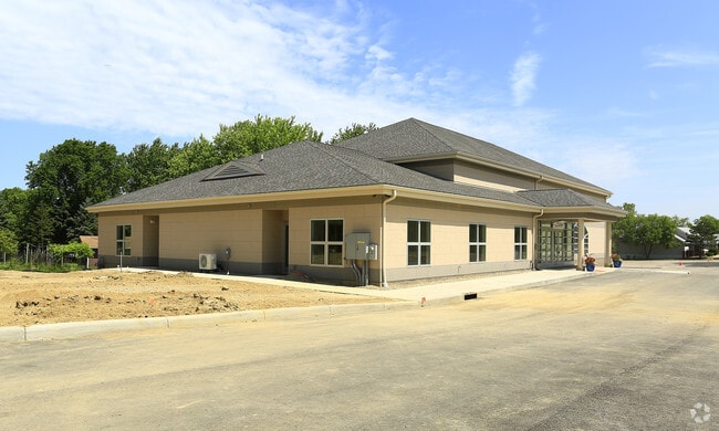
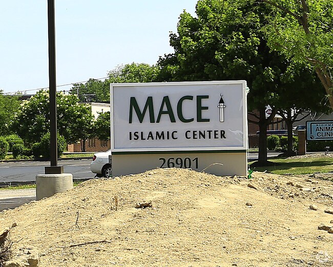
Property Record
26901 Chardon Rd, Richmond Hts, OH 44143

NEARBY LISTINGS FOR SALE OR LEASE
-
-
View all Richmond Hts listings for sale on LoopNet.com
Property Detail
26901 Chardon Rd
661-11-005
Ac Add
Religious
VOL 370 PG 16 PCL A FF 615.02 D 289.04 3.1277 AC ADDITIONAL PARCELS 66111007 66111011 & 66111097 2013 SR
X
Cuyahoga
39035C0103E
Ohio
2024
3.13 AC
2024
Northeast
180104
Cleveland
9,111 SF
Cleveland-Elyria, OH
DEMOGRAPHICS near 26901 Chardon Rd
1 Mile
3 Mile
5 Mile
2024 Total Population
12,237
82,747
201,908
2029 Population
12,334
81,586
198,816
Pop Growth 2024-2029
+ 0.79%
(1.40%)
(1.53%)
Average Age
42
42
43
2024 Total Households
6,122
37,436
92,702
HH Growth 2024-2029
+ 0.75%
(1.42%)
(1.57%)
Median Household Inc
$38,919
$49,448
$51,457
Avg Household Size
1.90
2.10
2.10
2024 Avg HH Vehicles
1.00
2.00
1.00
Median Home Value
$154,771
$144,562
$144,849
Median Year Built
1967
1959
1957
Nearby Places
Map Layers
Map Styles
 Street
 Aerial
- Restaurants
- Banks
- Shops
- Fitness
- Groceries
PUBLIC TRANSPORTATION
AIRPORT
Cleveland-Hopkins International
DRIVE
WALK
Distance
Cleveland-Hopkins International
41 min
26.7 mi
Freight Ports
Port of Toledo
DRIVE
WALK
Distance
Port of Toledo
155 min
127.1 mi
Nearby Properties
Address
Land Use
TOTAL SIZE
Lot Size
Zoning
Address
Land Use
TOTAL SIZE
Lot Size
Zoning
1,478,659 SF
50.49 AC
IG
Address
Land Use
TOTAL SIZE
Lot Size
Zoning
71.14 AC
U4
Address
Land Use
TOTAL SIZE
Lot Size
Zoning
44,577 SF
39.90 AC
SI
Address
Land Use
TOTAL SIZE
Lot Size
Zoning
252,759 SF
27.66 AC
R-1
Address
Land Use
TOTAL SIZE
Lot Size
Zoning
19,776 SF
13.41 AC
CI
Address
Land Use
TOTAL SIZE
Lot Size
Zoning
92,442 SF
159.84 AC
I-1
Address
Land Use
TOTAL SIZE
Lot Size
Zoning
166,392 SF
36.46 AC
RMF-2
Address
Land Use
TOTAL SIZE
Lot Size
Zoning
827,164 SF
8 AC
U3
Address
Land Use
TOTAL SIZE
Lot Size
Zoning
190,580 SF
7.90 AC
P.F.
Address
Land Use
TOTAL SIZE
Lot Size
Zoning
336,126 SF
72.98 AC
1-R
Address
Land Use
TOTAL SIZE
Lot Size
Zoning
2.53 AC
U6
Address
Land Use
TOTAL SIZE
Lot Size
Zoning
628,514 SF
25.95 AC
B-2
Address
Land Use
TOTAL SIZE
Lot Size
Zoning
39.06 AC
U6
Address
Land Use
TOTAL SIZE
Lot Size
Zoning
628,514 SF
0.67 AC
B-2
Address
Land Use
TOTAL SIZE
Lot Size
Zoning
300,691 SF
36.39 AC
1R
Address
Land Use
TOTAL SIZE
Lot Size
Zoning
10,200 SF
23.91 AC
Address
Land Use
TOTAL SIZE
Lot Size
Zoning
399,945 SF
34.80 AC
CI
Address
Land Use
TOTAL SIZE
Lot Size
Zoning
34.14 AC
U6
Address
Land Use
TOTAL SIZE
Lot Size
Zoning
0.23 AC
P-C-M
Address
Land Use
TOTAL SIZE
Lot Size
Zoning
27,466 SF
13.39 AC
U6
Address
Land Use
TOTAL SIZE
Lot Size
Zoning
102,182 SF
4.25 AC
M
Address
Land Use
TOTAL SIZE
Lot Size
Zoning
175,620 SF
8.65 AC
M
Address
Land Use
TOTAL SIZE
Lot Size
Zoning
208,610 SF
7.54 AC
M
Address
Land Use
TOTAL SIZE
Lot Size
Zoning
241,441 SF
17.18 AC
I
Address
Land Use
TOTAL SIZE
Lot Size
Zoning
70,574 SF
6.35 AC
CI
Address
Land Use
TOTAL SIZE
Lot Size
Zoning
187,994 SF
10 AC
P-C-M
Address
Land Use
TOTAL SIZE
Lot Size
Zoning
70,643 SF
8.26 AC
CI
Address
Land Use
TOTAL SIZE
Lot Size
Zoning
358,547 SF
8.22 AC
U3EL
Address
Land Use
TOTAL SIZE
Lot Size
Zoning
447,868 SF
6.22 AC
U3
Address
Land Use
TOTAL SIZE
Lot Size
Zoning
65,102 SF
8.80 AC
M
The World's #1 Commercial Real Estate Marketplace
Connect with us
© 2025 CoStar Group
The information above has been obtained from sources believed reliable. While we do not doubt its accuracy we have not verified it and make no guarantee, warranty or representation about it. It is your responsibility to independently confirm its accuracy and completeness. Any projections, opinions, assumptions, or estimates used are for example only and do not represent the current or future performance of the property. The value of this transaction to you depends on tax and other factors which should be evaluated by your tax, financial, and legal advisors. You and your advisors should conduct a careful, independent investigation of the property to determine to your satisfaction the suitability of the property for your needs.