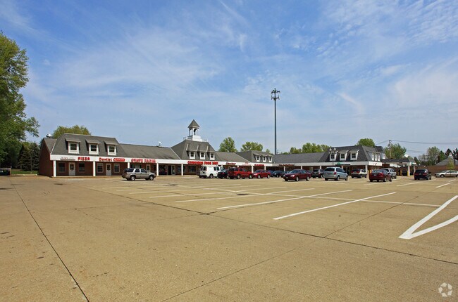
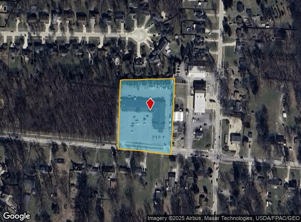
Property Record
26908 Cook Rd, Olmsted Twp, OH 44138


NEARBY LISTINGS FOR SALE OR LEASE
Property Detail
26908 Cook Rd
Cleveland-Elyria, OH
Olmsted 05
262-15-010
5 8
Stripcommercialcenter
Cuyahoga
X
Ohio
39035C0143E
5
2024
3.30 AC
2024
Southwest
190503
Cleveland
21,600 SF
DEMOGRAPHICS near 26908 Cook Rd
1 Mile
3 Mile
5 Mile
2024 Total Population
7,499
46,702
128,488
2029 Population
7,306
45,547
126,741
Pop Growth 2024-2029
(2.57%)
(2.47%)
(1.36%)
Average Age
47
43
44
2024 Total Households
3,345
19,398
52,999
HH Growth 2024-2029
(2.57%)
(2.60%)
(1.54%)
Median Household Inc
$67,863
$81,061
$81,783
Avg Household Size
2.20
2.40
2.30
2024 Avg HH Vehicles
2.00
2.00
2.00
Median Home Value
$196,323
$205,483
$205,050
Median Year Built
1984
1975
1972
Nearby Places
Map Layers
Map Styles
 Street
 Aerial
- Restaurants
- Banks
- Shops
- Fitness
- Groceries
PUBLIC TRANSPORTATION
AIRPORT
Cleveland-Hopkins International
DRIVE
WALK
Distance
Cleveland-Hopkins International
15 min
10.8 mi
Freight Ports
Port of Baltimore
DRIVE
WALK
Distance
Port of Baltimore
1 min
316.4 mi
SALE & LEASE HISTORY
LISTING DATE
SALE/LEASE

Sep 24, 2016
For Sale
May 01, 2020
For Lease
May 01, 2019
For Lease
Aug 16, 2017
For Lease
Apr 26, 2019
For Sale
Nearby Properties
Address
Land Use
TOTAL SIZE
Lot Size
Zoning
Address
Land Use
TOTAL SIZE
Lot Size
Zoning
327,732 SF
57.22 AC
1F
Address
Land Use
TOTAL SIZE
Lot Size
Zoning
457,220 SF
41.84 AC
CRG
Address
Land Use
TOTAL SIZE
Lot Size
Zoning
633,719 SF
17.16 AC
CRG
Address
Land Use
TOTAL SIZE
Lot Size
Zoning
278,056 SF
42.71 AC
R-40
Address
Land Use
TOTAL SIZE
Lot Size
Zoning
195,990 SF
46.88 AC
RMF-A
Address
Land Use
TOTAL SIZE
Lot Size
Zoning
64,528 SF
17.67 AC
1F-4
Address
Land Use
TOTAL SIZE
Lot Size
Zoning
176,857 SF
8.62 AC
B-2
Address
Land Use
TOTAL SIZE
Lot Size
Zoning
46,133 SF
35.03 AC
RMF-A
Address
Land Use
TOTAL SIZE
Lot Size
Zoning
209,822 SF
26.92 AC
R-40
Address
Land Use
TOTAL SIZE
Lot Size
Zoning
50,668 SF
9.04 AC
Address
Land Use
TOTAL SIZE
Lot Size
Zoning
130,030 SF
5.69 AC
RMF-A
Address
Land Use
TOTAL SIZE
Lot Size
Zoning
19,614 SF
353.71 AC
1F-4
Address
Land Use
TOTAL SIZE
Lot Size
Zoning
128,416 SF
13.42 AC
R-40
Address
Land Use
TOTAL SIZE
Lot Size
Zoning
185,847 SF
17.72 AC
CRG
Address
Land Use
TOTAL SIZE
Lot Size
Zoning
163,501 SF
9.88 AC
CRG
Address
Land Use
TOTAL SIZE
Lot Size
Zoning
141,245 SF
8.90 AC
1F1
Address
Land Use
TOTAL SIZE
Lot Size
Zoning
174,721 SF
15.60 AC
Address
Land Use
TOTAL SIZE
Lot Size
Zoning
179,879 SF
5.34 AC
RMF-A
Address
Land Use
TOTAL SIZE
Lot Size
Zoning
330,163 SF
5.06 AC
MRC2
Address
Land Use
TOTAL SIZE
Lot Size
Zoning
284,727 SF
12.45 AC
MRC2
Address
Land Use
TOTAL SIZE
Lot Size
Zoning
43,950 SF
9.40 AC
Address
Land Use
TOTAL SIZE
Lot Size
Zoning
584,822 SF
4.65 AC
MRC2
Address
Land Use
TOTAL SIZE
Lot Size
Zoning
89,153 SF
29.03 AC
1F-4
Address
Land Use
TOTAL SIZE
Lot Size
Zoning
188,031 SF
16.59 AC
R-40
Address
Land Use
TOTAL SIZE
Lot Size
Zoning
67,047 SF
5 AC
1F-4
Address
Land Use
TOTAL SIZE
Lot Size
Zoning
122,421 SF
16.38 AC
1F-4
Address
Land Use
TOTAL SIZE
Lot Size
Zoning
168,216 SF
14.92 AC
MRC2
Address
Land Use
TOTAL SIZE
Lot Size
Zoning
54,718 SF
149.12 AC
R-40
Address
Land Use
TOTAL SIZE
Lot Size
Zoning
60,371 SF
12.59 AC
Address
Land Use
TOTAL SIZE
Lot Size
Zoning
57,126 SF
11.74 AC
The World's #1 Commercial Real Estate Marketplace
Connect with us
© 2025 CoStar Group
The information above has been obtained from sources believed reliable. While we do not doubt its accuracy we have not verified it and make no guarantee, warranty or representation about it. It is your responsibility to independently confirm its accuracy and completeness. Any projections, opinions, assumptions, or estimates used are for example only and do not represent the current or future performance of the property. The value of this transaction to you depends on tax and other factors which should be evaluated by your tax, financial, and legal advisors. You and your advisors should conduct a careful, independent investigation of the property to determine to your satisfaction the suitability of the property for your needs.