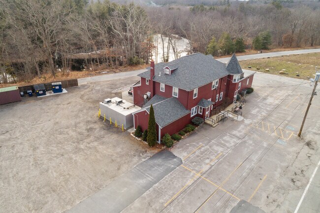
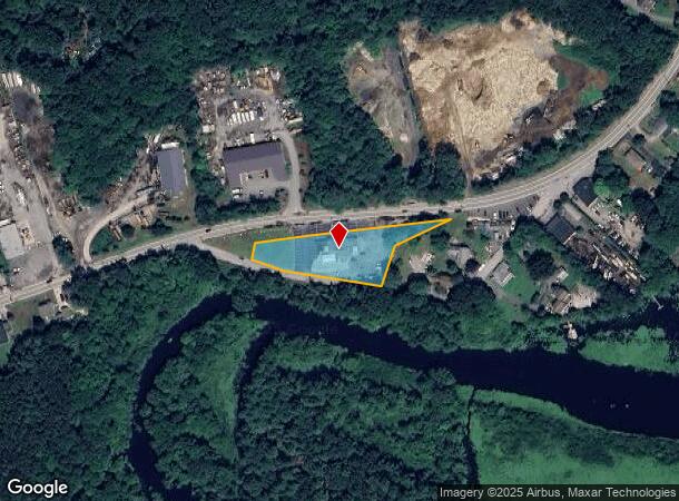
Property Record
2692 Victory Hwy, Harrisville, RI 02830
NEARBY LISTINGS FOR SALE OR LEASE
-
-
View all Harrisville listings for sale on LoopNet.com
Property Detail
2692 Victory Hwy
BURR-000114-000000-000051
Providence
Commercialofficeresidentialmixeduse
Rhode Island
X
51
44007C0151G
1.03 AC
2025
Burrillville/Glocester
2025
Providence
013002
Providence-Warwick, RI-MA
5,074 SF
DEMOGRAPHICS near 2692 Victory Hwy
1 Mile
3 Mile
5 Mile
2024 Total Population
1,006
11,625
46,462
2029 Population
1,005
11,640
46,314
Pop Growth 2024-2029
(0.10%)
+ 0.13%
(0.32%)
Average Age
42
43
41
2024 Total Households
382
4,514
17,974
HH Growth 2024-2029
(0.26%)
0.00%
(0.42%)
Median Household Inc
$111,206
$101,161
$82,077
Avg Household Size
2.60
2.50
2.50
2024 Avg HH Vehicles
2.00
2.00
2.00
Median Home Value
$351,562
$367,351
$362,694
Median Year Built
1966
1972
1961
Nearby Places
Map Layers
Map Styles
 Street
 Aerial
- Restaurants
- Banks
- Shops
- Fitness
- Groceries
PUBLIC TRANSPORTATION
AIRPORT
Rhode Island Tf Green International
DRIVE
WALK
Distance
Rhode Island Tf Green International
38 min
25.0 mi
Worcester Regional
DRIVE
WALK
Distance
Worcester Regional
43 min
29.9 mi
Freight Ports
Port of Davisville, RI
DRIVE
WALK
Distance
Port of Davisville, RI
50 min
34.2 mi
SALE & LEASE HISTORY
LISTING DATE
SALE/LEASE

Oct 14, 2021
For Sale
Mar 26, 2024
For Sale
Nearby Properties
Address
Land Use
TOTAL SIZE
Lot Size
Zoning
Address
Land Use
TOTAL SIZE
Lot Size
Zoning
602,336 SF
204.50 AC
B
Address
Land Use
TOTAL SIZE
Lot Size
Zoning
31.45 AC
M
Address
Land Use
TOTAL SIZE
Lot Size
Zoning
10.43 AC
R20
Address
Land Use
TOTAL SIZE
Lot Size
Zoning
34.30 AC
M
Address
Land Use
TOTAL SIZE
Lot Size
Zoning
28.39 AC
F5
Address
Land Use
TOTAL SIZE
Lot Size
Zoning
27,720 SF
4.36 AC
I
Address
Land Use
TOTAL SIZE
Lot Size
Zoning
65,809 SF
17.66 AC
BN
Address
Land Use
TOTAL SIZE
Lot Size
Zoning
42,837 SF
11.32 AC
RS
Address
Land Use
TOTAL SIZE
Lot Size
Zoning
18.32 AC
M
Address
Land Use
TOTAL SIZE
Lot Size
Zoning
21,080 SF
34.04 AC
RA
Address
Land Use
TOTAL SIZE
Lot Size
Zoning
44.50 AC
F5
Address
Land Use
TOTAL SIZE
Lot Size
Zoning
57,698 SF
8.36 AC
RS
Address
Land Use
TOTAL SIZE
Lot Size
Zoning
55,730 SF
8.23 AC
GC
Address
Land Use
TOTAL SIZE
Lot Size
Zoning
44.16 AC
GI
Address
Land Use
TOTAL SIZE
Lot Size
Zoning
1,293.70 AC
OS
Address
Land Use
TOTAL SIZE
Lot Size
Zoning
83,475 SF
16.06 AC
Address
Land Use
TOTAL SIZE
Lot Size
Zoning
8,736 SF
35.28 AC
REA
Address
Land Use
TOTAL SIZE
Lot Size
Zoning
85,632 SF
6.69 AC
M
Address
Land Use
TOTAL SIZE
Lot Size
Zoning
78,752 SF
6.26 AC
M
Address
Land Use
TOTAL SIZE
Lot Size
Zoning
6.93 AC
GC
Address
Land Use
TOTAL SIZE
Lot Size
Zoning
19,720 SF
6.89 AC
M
Address
Land Use
TOTAL SIZE
Lot Size
Zoning
2.51 AC
RA
Address
Land Use
TOTAL SIZE
Lot Size
Zoning
25,600 SF
Address
Land Use
TOTAL SIZE
Lot Size
Zoning
72,634 SF
6.80 AC
M
Address
Land Use
TOTAL SIZE
Lot Size
Zoning
54.64 AC
REA
Address
Land Use
TOTAL SIZE
Lot Size
Zoning
32,428 SF
5.99 AC
B
Address
Land Use
TOTAL SIZE
Lot Size
Zoning
8.24 AC
F5
Address
Land Use
TOTAL SIZE
Lot Size
Zoning
31,659 SF
21.32 AC
GI
Address
Land Use
TOTAL SIZE
Lot Size
Zoning
12,848 SF
2.62 AC
RS
Address
Land Use
TOTAL SIZE
Lot Size
Zoning
65,194 SF
8.71 AC
GI
The World's #1 Commercial Real Estate Marketplace
Connect with us
© 2025 CoStar Group
The information above has been obtained from sources believed reliable. While we do not doubt its accuracy we have not verified it and make no guarantee, warranty or representation about it. It is your responsibility to independently confirm its accuracy and completeness. Any projections, opinions, assumptions, or estimates used are for example only and do not represent the current or future performance of the property. The value of this transaction to you depends on tax and other factors which should be evaluated by your tax, financial, and legal advisors. You and your advisors should conduct a careful, independent investigation of the property to determine to your satisfaction the suitability of the property for your needs.