Property Record
2695 Dave Ward Dr, Conway, AR 72034
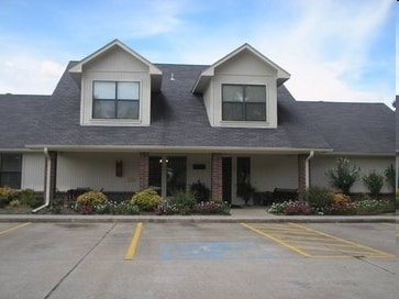

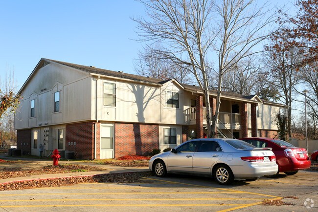
Property Detail
2695 Dave Ward Dr
710-08552-000
PT E 1/2 SW
Apartment
Faulkner
B and X Area of moderate flood hazard, usually the area between the limits of the 100-year and 500-year floods.
Arkansas
2025
8.81 AC
2025
Conway
031003
Little Rock/N Little Rock
10,162 SF
Little Rock-North Little Rock-Conway, AR
NEARBY LISTINGS FOR SALE OR LEASE
DEMOGRAPHICS near 2695 Dave Ward Dr
1 mile
3 mile
5 mile
2025 Total Population
12,978
55,218
73,797
2030 Population
13,597
58,065
77,692
Pop Growth 2025-2030
+ 4.77%
+ 5.16%
+ 5.28%
Average Age
32
35
36
2025 Total Households
4,710
21,880
29,184
HH Growth 2025-2030
+ 5.69%
+ 5.55%
+ 5.64%
Median Household Inc
$49,965
$62,328
$64,676
Avg Household Size
2.20
2.30
2.30
2025 Avg HH Vehicles
2.00
2.00
2.00
Median Home Value
$250,649
$263,540
$263,589
Median Year Built
1998
1996
1997
Nearby Places
Map Layers
Map Styles
 Street
 Aerial
Layers
 Traffic
 Biking
Places
Listings with unknown addresses are not visible on the map
- Restaurants
- Banks
- Shops
- Fitness
- Groceries
PUBLIC TRANSPORTATION
AIRPORT
Bill and Hillary Clinton Ntl/Adams Field
Drive
Walk
Distance
Bill and Hillary Clinton Ntl/Adams Field
42 min
34.3 mi
Freight Ports
Tulsa Port of Inola
Drive
Walk
Distance
Tulsa Port of Inola
258 min
232.0 mi
Nearby Properties
Address
Land Use
TOTAL SIZE
Lot Size
Zoning
Address
Land Use
TOTAL SIZE
Lot Size
Zoning
158,289 SF
28.42 AC
Address
Land Use
TOTAL SIZE
Lot Size
Zoning
214,622 SF
38.85 AC
Address
Land Use
TOTAL SIZE
Lot Size
Zoning
123,032 SF
9.59 AC
Address
Land Use
TOTAL SIZE
Lot Size
Zoning
94,854 SF
10.40 AC
Address
Land Use
TOTAL SIZE
Lot Size
Zoning
89,037 SF
11.30 AC
Address
Land Use
TOTAL SIZE
Lot Size
Zoning
164,655 SF
10.36 AC
Address
Land Use
TOTAL SIZE
Lot Size
Zoning
26,928 SF
2.37 AC
Address
Land Use
TOTAL SIZE
Lot Size
Zoning
26,608 SF
17.40 AC
Address
Land Use
TOTAL SIZE
Lot Size
Zoning
1,215,537 SF
67.98 AC
Address
Land Use
TOTAL SIZE
Lot Size
Zoning
38,442 SF
30.57 AC
Address
Land Use
TOTAL SIZE
Lot Size
Zoning
21,204 SF
65.01 AC
Address
Land Use
TOTAL SIZE
Lot Size
Zoning
21,664 SF
13.85 AC
Address
Land Use
TOTAL SIZE
Lot Size
Zoning
77,129 SF
12.84 AC
Address
Land Use
TOTAL SIZE
Lot Size
Zoning
21,532 SF
13.21 AC
Address
Land Use
TOTAL SIZE
Lot Size
Zoning
85,354 SF
5.61 AC
Address
Land Use
TOTAL SIZE
Lot Size
Zoning
77,061 SF
3.07 AC
Address
Land Use
TOTAL SIZE
Lot Size
Zoning
30,312 SF
7.24 AC
Address
Land Use
TOTAL SIZE
Lot Size
Zoning
43,340 SF
28.77 AC
Address
Land Use
TOTAL SIZE
Lot Size
Zoning
34,086 SF
9.77 AC
Address
Land Use
TOTAL SIZE
Lot Size
Zoning
32,900 SF
21.54 AC
Address
Land Use
TOTAL SIZE
Lot Size
Zoning
58,561 SF
47.36 AC
Address
Land Use
TOTAL SIZE
Lot Size
Zoning
98,915 SF
2.77 AC
Address
Land Use
TOTAL SIZE
Lot Size
Zoning
73,124 SF
11.60 AC
Address
Land Use
TOTAL SIZE
Lot Size
Zoning
138,840 SF
15.46 AC
Address
Land Use
TOTAL SIZE
Lot Size
Zoning
31,584 SF
8.60 AC
Address
Land Use
TOTAL SIZE
Lot Size
Zoning
12,419 SF
1.56 AC
Address
Land Use
TOTAL SIZE
Lot Size
Zoning
154,053 SF
15.07 AC
Address
Land Use
TOTAL SIZE
Lot Size
Zoning
21,204 SF
25.71 AC
Address
Land Use
TOTAL SIZE
Lot Size
Zoning
126,911 SF
10.19 AC
Address
Land Use
TOTAL SIZE
Lot Size
Zoning
22,100 SF
1.42 AC
The World's #1 Commercial Real Estate Marketplace
Connect with us
© 2026 CoStar Group
The information above has been obtained from sources believed reliable. While we do not doubt its accuracy we have not verified it and make no guarantee, warranty or representation about it. It is your responsibility to independently confirm its accuracy and completeness. Any projections, opinions, assumptions, or estimates used are for example only and do not represent the current or future performance of the property. The value of this transaction to you depends on tax and other factors which should be evaluated by your tax, financial, and legal advisors. You and your advisors should conduct a careful, independent investigation of the property to determine to your satisfaction the suitability of the property for your needs.