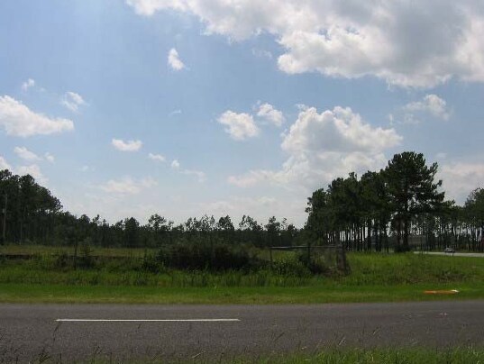
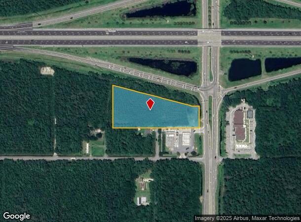
Property Record
2699 Avalon Blvd, Milton, FL 32583
NEARBY LISTINGS FOR SALE OR LEASE
Property Detail
2699 Avalon Blvd
Pensacola-Ferry Pass-Brent, FL
Avalon Beach
40-1N-28-0090-32500-0040
AVALON BEACH LOTS 4,5,6,7,8, 17,18,19,20,21,& 22 BLK 325 & WITH THAT PORT OF VAC 30 FT ALLEYWAY BETWEEN SAID LOTS VACATED IN OR 1716 PG 1213 & ALL OF LOTS 17,18,19 & W 80 FT OF LOTS 7 & 8 & PORT OF LOTS 6 & 20 LESS HWY R/W IN BLK 326 & PART OF LOTS 5
Commercialacreage
Santa Rosa
AE
Florida
12113C0440H
4
2024
2.72 AC
2025
Avalon Beach/Milton
010710
Pensacola
DEMOGRAPHICS near 2699 Avalon Blvd
1 Mile
3 Mile
5 Mile
2024 Total Population
479
5,634
21,351
2029 Population
555
6,537
24,561
Pop Growth 2024-2029
+ 15.87%
+ 16.03%
+ 15.03%
Average Age
43
42
41
2024 Total Households
188
2,193
8,258
HH Growth 2024-2029
+ 15.96%
+ 16.37%
+ 15.29%
Median Household Inc
$85,577
$99,203
$80,341
Avg Household Size
2.50
2.60
2.60
2024 Avg HH Vehicles
2.00
2.00
2.00
Median Home Value
$277,678
$267,420
$232,321
Median Year Built
2001
2001
1997
Nearby Places
Map Layers
Map Styles
 Street
 Aerial
- Restaurants
- Banks
- Shops
- Fitness
- Groceries
PUBLIC TRANSPORTATION
AIRPORT
Pensacola International
DRIVE
WALK
Distance
Pensacola International
21 min
12.5 mi
Freight Ports
Port of Mobile
DRIVE
WALK
Distance
Port of Mobile
71 min
62.6 mi
Nearby Properties
Address
Land Use
TOTAL SIZE
Lot Size
Zoning
Address
Land Use
TOTAL SIZE
Lot Size
Zoning
615,804 SF
16.46 AC
M2
Address
Land Use
TOTAL SIZE
Lot Size
Zoning
40,026 SF
1.79 AC
HCD
Address
Land Use
TOTAL SIZE
Lot Size
Zoning
37,232 SF
303.14 AC
HCD
Address
Land Use
TOTAL SIZE
Lot Size
Zoning
18,920 SF
3.65 AC
R3
Address
Land Use
TOTAL SIZE
Lot Size
Zoning
17,449 SF
39.90 AC
R1
Address
Land Use
TOTAL SIZE
Lot Size
Zoning
10,095 SF
1.03 AC
HCD
Address
Land Use
TOTAL SIZE
Lot Size
Zoning
9,081 SF
1.88 AC
HCD
Address
Land Use
TOTAL SIZE
Lot Size
Zoning
40,994 SF
57.36 AC
RR1
Address
Land Use
TOTAL SIZE
Lot Size
Zoning
15,375 SF
1.85 AC
M1
Address
Land Use
TOTAL SIZE
Lot Size
Zoning
10,008 SF
1.10 AC
HCD
Address
Land Use
TOTAL SIZE
Lot Size
Zoning
1,485 SF
3.14 AC
HCD
Address
Land Use
TOTAL SIZE
Lot Size
Zoning
11,241 SF
1.50 AC
HCD
Address
Land Use
TOTAL SIZE
Lot Size
Zoning
25,323 SF
2 AC
HCD
Address
Land Use
TOTAL SIZE
Lot Size
Zoning
627 SF
2.07 AC
HCD
Address
Land Use
TOTAL SIZE
Lot Size
Zoning
21,064 SF
3.10 AC
HCD
Address
Land Use
TOTAL SIZE
Lot Size
Zoning
4,327 SF
0.83 AC
HCD
Address
Land Use
TOTAL SIZE
Lot Size
Zoning
6,006 SF
0.83 AC
HCD
Address
Land Use
TOTAL SIZE
Lot Size
Zoning
12,854 SF
0.14 AC
M2
Address
Land Use
TOTAL SIZE
Lot Size
Zoning
7,500 SF
2.48 AC
M1
Address
Land Use
TOTAL SIZE
Lot Size
Zoning
8,516 SF
18.67 AC
AG-RR
Address
Land Use
TOTAL SIZE
Lot Size
Zoning
8,849 SF
37.72 AC
RR1
Address
Land Use
TOTAL SIZE
Lot Size
Zoning
1.96 AC
HCD
Address
Land Use
TOTAL SIZE
Lot Size
Zoning
5,166 SF
36.44 AC
AG-RR
Address
Land Use
TOTAL SIZE
Lot Size
Zoning
8,726 SF
11.77 AC
AG-RR
Address
Land Use
TOTAL SIZE
Lot Size
Zoning
9,715 SF
1.05 AC
HCD
Address
Land Use
TOTAL SIZE
Lot Size
Zoning
15.95 AC
M2
Address
Land Use
TOTAL SIZE
Lot Size
Zoning
896 SF
21.97 AC
AG-RR
Address
Land Use
TOTAL SIZE
Lot Size
Zoning
5,523 SF
3 AC
R1
The World's #1 Commercial Real Estate Marketplace
Connect with us
© 2025 CoStar Group
The information above has been obtained from sources believed reliable. While we do not doubt its accuracy we have not verified it and make no guarantee, warranty or representation about it. It is your responsibility to independently confirm its accuracy and completeness. Any projections, opinions, assumptions, or estimates used are for example only and do not represent the current or future performance of the property. The value of this transaction to you depends on tax and other factors which should be evaluated by your tax, financial, and legal advisors. You and your advisors should conduct a careful, independent investigation of the property to determine to your satisfaction the suitability of the property for your needs.