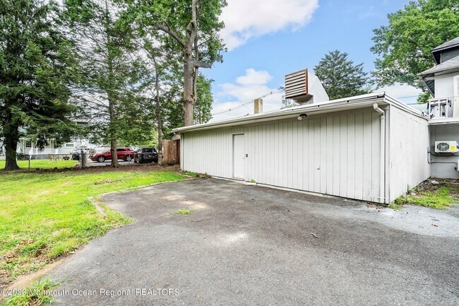
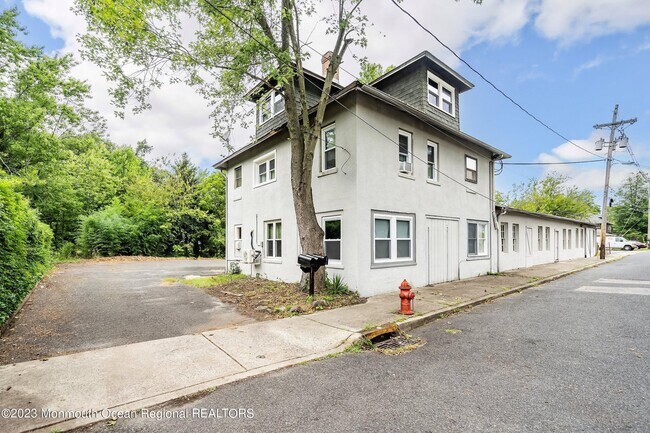
Property Record
27 Boud Ave, Farmingdale, NJ 07727
NEARBY LISTINGS FOR SALE OR LEASE
Property Detail
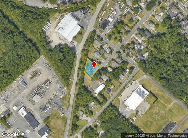
27 Boud Ave
15-00032-0000-00004
Monmouth
Industrialgeneral
New Jersey
X
4
34025C0310F
0.19 AC
2024
Western Monmouth
2025
Northern New Jersey
811600
New York-Jersey City-White Plains, NY-NJ
5,649 SF
DEMOGRAPHICS near 27 Boud Ave
1 Mile
3 Mile
5 Mile
2024 Total Population
2,229
10,444
51,239
2029 Population
2,264
10,417
50,795
Pop Growth 2024-2029
+ 1.57%
(0.26%)
(0.87%)
Average Age
40
43
42
2024 Total Households
866
3,847
18,368
HH Growth 2024-2029
+ 1.15%
(0.31%)
(1.05%)
Median Household Inc
$91,993
$113,586
$114,947
Avg Household Size
2.50
2.60
2.70
2024 Avg HH Vehicles
2.00
2.00
2.00
Median Home Value
$428,161
$552,056
$439,778
Median Year Built
1976
1986
1984
Nearby Places
Map Layers
Map Styles
 Street
 Aerial
- Restaurants
- Banks
- Shops
- Fitness
- Groceries
PUBLIC TRANSPORTATION
COMMUTER RAIL
Belmar (North Jersey Coast Line - NJ Transit Commuter Rail (NJ Transit))
DRIVE
WALK
Distance
Belmar (North Jersey Coast Line - NJ Transit Commuter Rail (NJ Transit))
14 min
9.9 mi
Freight Ports
New York Container Terminal
DRIVE
WALK
Distance
New York Container Terminal
56 min
41.3 mi
SALE & LEASE HISTORY
LISTING DATE
SALE/LEASE

Aug 14, 2023
For Lease
Nearby Properties
Address
Land Use
TOTAL SIZE
Lot Size
Zoning
Address
Land Use
TOTAL SIZE
Lot Size
Zoning
152,121 SF
22.16 AC
OR10
Address
Land Use
TOTAL SIZE
Lot Size
Zoning
192,708 SF
33.36 AC
OR10
Address
Land Use
TOTAL SIZE
Lot Size
Zoning
13 AC
R-40
Address
Land Use
TOTAL SIZE
Lot Size
Zoning
25,536 SF
21.95 AC
OR10
Address
Land Use
TOTAL SIZE
Lot Size
Zoning
17,586 SF
386.01 AC
POS
Address
Land Use
TOTAL SIZE
Lot Size
Zoning
120,000 SF
77 AC
ARE2
Address
Land Use
TOTAL SIZE
Lot Size
Zoning
912 SF
201.36 AC
RRC
Address
Land Use
TOTAL SIZE
Lot Size
Zoning
240,362 SF
61.13 AC
ARE6
Address
Land Use
TOTAL SIZE
Lot Size
Zoning
3,400 SF
262.97 AC
AI
Address
Land Use
TOTAL SIZE
Lot Size
Zoning
332,213 SF
26.55 AC
OR10
Address
Land Use
TOTAL SIZE
Lot Size
Zoning
2,976 SF
336.41 AC
POS
Address
Land Use
TOTAL SIZE
Lot Size
Zoning
13,350 SF
71.10 AC
ARE6
Address
Land Use
TOTAL SIZE
Lot Size
Zoning
161,000 SF
21.60 AC
ARE2
Address
Land Use
TOTAL SIZE
Lot Size
Zoning
142,676 SF
10.47 AC
OR-2
Address
Land Use
TOTAL SIZE
Lot Size
Zoning
79,746 SF
9.06 AC
OR10
Address
Land Use
TOTAL SIZE
Lot Size
Zoning
4,060 SF
270.36 AC
CR40
Address
Land Use
TOTAL SIZE
Lot Size
Zoning
55,984 SF
16.11 AC
LI
Address
Land Use
TOTAL SIZE
Lot Size
Zoning
6.04 AC
OP-2
Address
Land Use
TOTAL SIZE
Lot Size
Zoning
10.11 AC
SED
Address
Land Use
TOTAL SIZE
Lot Size
Zoning
7,064 SF
10.62 AC
OR10
Address
Land Use
TOTAL SIZE
Lot Size
Zoning
91,180 SF
27.20 AC
SED
Address
Land Use
TOTAL SIZE
Lot Size
Zoning
86,936 SF
3.42 AC
LI
Address
Land Use
TOTAL SIZE
Lot Size
Zoning
76,850 SF
9.90 AC
OR10
Address
Land Use
TOTAL SIZE
Lot Size
Zoning
42.76 AC
SED
Address
Land Use
TOTAL SIZE
Lot Size
Zoning
33,128 SF
12.68 AC
ARE6
Address
Land Use
TOTAL SIZE
Lot Size
Zoning
8,676 SF
8.19 AC
OP-2
Address
Land Use
TOTAL SIZE
Lot Size
Zoning
212.49 AC
ARE6
Address
Land Use
TOTAL SIZE
Lot Size
Zoning
27,105 SF
9.41 AC
OP-2
Address
Land Use
TOTAL SIZE
Lot Size
Zoning
13.33 AC
SED
Address
Land Use
TOTAL SIZE
Lot Size
Zoning
7.04 AC
SED
The World's #1 Commercial Real Estate Marketplace
Connect with us
© 2025 CoStar Group
The information above has been obtained from sources believed reliable. While we do not doubt its accuracy we have not verified it and make no guarantee, warranty or representation about it. It is your responsibility to independently confirm its accuracy and completeness. Any projections, opinions, assumptions, or estimates used are for example only and do not represent the current or future performance of the property. The value of this transaction to you depends on tax and other factors which should be evaluated by your tax, financial, and legal advisors. You and your advisors should conduct a careful, independent investigation of the property to determine to your satisfaction the suitability of the property for your needs.