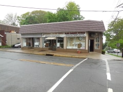
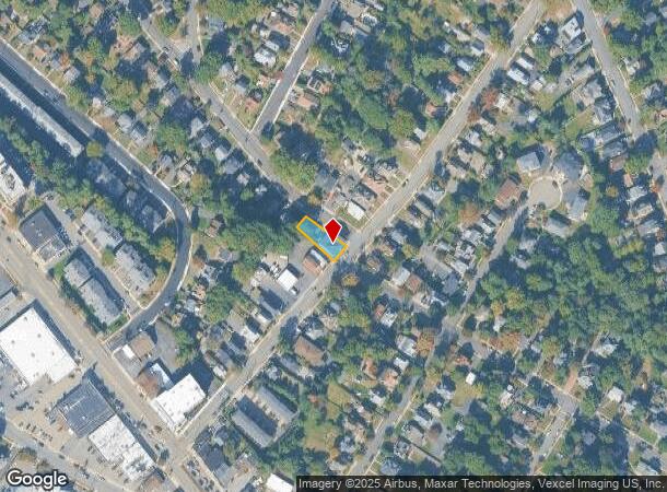
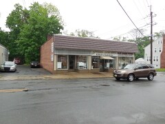
Property Record
27 Central Ave, Newark, NJ 07102
NEARBY LISTINGS FOR SALE OR LEASE
Property Detail
27 Central Ave
03-00036-0000-00015
0.1421 AC CONDO MOTHER LOT
Storebuilding
Essex
X
New Jersey
34013C0082G
15
0
0.14 AC
2025
Suburban Essex/Rt 280
021701
Northern New Jersey
2,462 SF
Newark, NJ
DEMOGRAPHICS near 27 Central Ave
1 Mile
3 Mile
5 Mile
2024 Total Population
16,565
76,528
229,930
2029 Population
16,335
76,027
227,863
Pop Growth 2024-2029
(1.39%)
(0.65%)
(0.90%)
Average Age
41
43
42
2024 Total Households
6,227
28,280
83,873
HH Growth 2024-2029
(1.57%)
(0.88%)
(1.05%)
Median Household Inc
$114,856
$135,659
$130,737
Avg Household Size
2.50
2.60
2.60
2024 Avg HH Vehicles
2.00
2.00
2.00
Median Home Value
$576,521
$619,464
$613,317
Median Year Built
1955
1960
1958
Nearby Places
Map Layers
Map Styles
 Street
 Aerial
- Restaurants
- Banks
- Shops
- Fitness
- Groceries
PUBLIC TRANSPORTATION
COMMUTER RAIL
Little Falls (Montclair-Boonton Line - NJ Transit Commuter Rail (NJ Transit))
DRIVE
WALK
Distance
Little Falls (Montclair-Boonton Line - NJ Transit Commuter Rail (NJ Transit))
8 min
4.5 mi
Upper Montclair (Montclair-Boonton Line - NJ Transit Commuter Rail (NJ Transit))
DRIVE
WALK
Distance
Upper Montclair (Montclair-Boonton Line - NJ Transit Commuter Rail (NJ Transit))
11 min
5.4 mi
AIRPORT
Newark Liberty International
DRIVE
WALK
Distance
Newark Liberty International
27 min
15.8 mi
LaGuardia
DRIVE
WALK
Distance
LaGuardia
49 min
35.0 mi
John F Kennedy International
DRIVE
WALK
Distance
John F Kennedy International
60 min
46.1 mi
Freight Ports
Port Newark Container Terminal
DRIVE
WALK
Distance
Port Newark Container Terminal
29 min
15.6 mi
Nearby Properties
Address
Land Use
TOTAL SIZE
Lot Size
Zoning
Address
Land Use
TOTAL SIZE
Lot Size
Zoning
74.58 AC
S
Address
Land Use
TOTAL SIZE
Lot Size
Zoning
48.85 AC
R-3B
Address
Land Use
TOTAL SIZE
Lot Size
Zoning
98.27 AC
AH1
Address
Land Use
TOTAL SIZE
Lot Size
Zoning
13 AC
RM
Address
Land Use
TOTAL SIZE
Lot Size
Zoning
101.44 AC
OB-1
Address
Land Use
TOTAL SIZE
Lot Size
Zoning
32.34 AC
RA
Address
Land Use
TOTAL SIZE
Lot Size
Zoning
55.77 AC
OB-1
Address
Land Use
TOTAL SIZE
Lot Size
Zoning
4.60 AC
Address
Land Use
TOTAL SIZE
Lot Size
Zoning
51.24 AC
OB-2
Address
Land Use
TOTAL SIZE
Lot Size
Zoning
8,600 SF
27.27 AC
L3
Address
Land Use
TOTAL SIZE
Lot Size
Zoning
84.70 AC
Address
Land Use
TOTAL SIZE
Lot Size
Zoning
17.90 AC
B-2
Address
Land Use
TOTAL SIZE
Lot Size
Zoning
25.88 AC
Address
Land Use
TOTAL SIZE
Lot Size
Zoning
41.84 AC
OB-1
Address
Land Use
TOTAL SIZE
Lot Size
Zoning
67.49 AC
Address
Land Use
TOTAL SIZE
Lot Size
Zoning
61.69 AC
Address
Land Use
TOTAL SIZE
Lot Size
Zoning
1,760 SF
189.03 AC
R-2
Address
Land Use
TOTAL SIZE
Lot Size
Zoning
27.50 AC
M-2
Address
Land Use
TOTAL SIZE
Lot Size
Zoning
6.01 AC
OB-2
Address
Land Use
TOTAL SIZE
Lot Size
Zoning
5.74 AC
B-2
Address
Land Use
TOTAL SIZE
Lot Size
Zoning
31.56 AC
R-3
Address
Land Use
TOTAL SIZE
Lot Size
Zoning
38.40 AC
Address
Land Use
TOTAL SIZE
Lot Size
Zoning
28.06 AC
OB-3
Address
Land Use
TOTAL SIZE
Lot Size
Zoning
Address
Land Use
TOTAL SIZE
Lot Size
Zoning
7,507 SF
18.82 AC
L-1
Address
Land Use
TOTAL SIZE
Lot Size
Zoning
259,325 SF
13.62 AC
I1A
Address
Land Use
TOTAL SIZE
Lot Size
Zoning
4.08 AC
Address
Land Use
TOTAL SIZE
Lot Size
Zoning
32.99 AC
R-4
Address
Land Use
TOTAL SIZE
Lot Size
Zoning
10.69 AC
M-2
Address
Land Use
TOTAL SIZE
Lot Size
Zoning
1,063 SF
14.08 AC
C-1
The World's #1 Commercial Real Estate Marketplace
Connect with us
© 2026 CoStar Group
The information above has been obtained from sources believed reliable. While we do not doubt its accuracy we have not verified it and make no guarantee, warranty or representation about it. It is your responsibility to independently confirm its accuracy and completeness. Any projections, opinions, assumptions, or estimates used are for example only and do not represent the current or future performance of the property. The value of this transaction to you depends on tax and other factors which should be evaluated by your tax, financial, and legal advisors. You and your advisors should conduct a careful, independent investigation of the property to determine to your satisfaction the suitability of the property for your needs.