Property Record
27 Depot St, Broad Brook, CT 06016
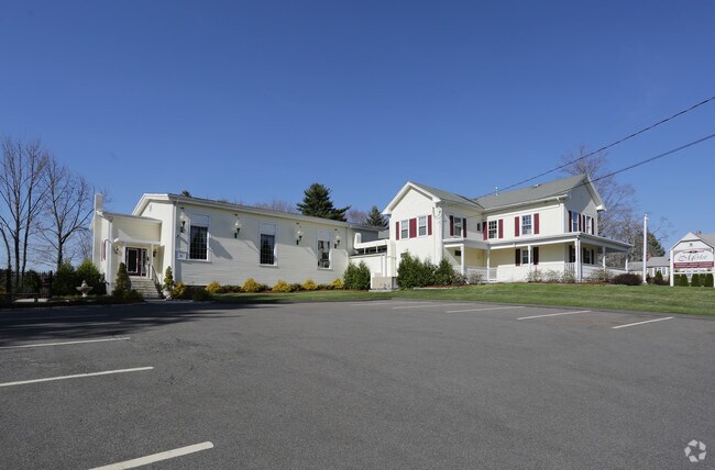

This Property Is For Sale
Property Detail
27 Depot St
EWIN-000098-000044-000041
Capitol
Commercialbuilding
Connecticut
B-1
41
AE The base floodplain where base flood elevations are provided. AE Zones are now used on new format FIRMs instead of A1-A30 Zones.
1.24 AC
2025
East Windsor
2025
Hartford
484200
Hartford-West Hartford-East Hartford, CT
5,904 SF
NEARBY LISTINGS FOR SALE OR LEASE
-
-
View all Broad Brook listings for sale on LoopNet.com
DEMOGRAPHICS near 27 Depot St
1 mile
3 mile
5 mile
2025 Total Population
3,003
13,318
54,686
2030 Population
3,071
13,563
55,827
Pop Growth 2025-2030
+ 2.26%
+ 1.84%
+ 2.09%
Average Age
43
44
43
2025 Total Households
1,296
5,458
22,865
HH Growth 2025-2030
+ 2.24%
+ 1.91%
+ 2.16%
Median Household Inc
$104,666
$110,338
$102,776
Avg Household Size
2.30
2.40
2.30
2025 Avg HH Vehicles
2.00
2.00
2.00
Median Home Value
$357,564
$313,963
$305,659
Median Year Built
1975
1976
1973
Nearby Places
Map Layers
Map Styles
 Street
 Aerial
Layers
 Traffic
 Biking
Places
Listings with unknown addresses are not visible on the map
- Restaurants
- Banks
- Shops
- Fitness
- Groceries
PUBLIC TRANSPORTATION
COMMUTER RAIL
Windsor Locks (Hartford Line - CT Rail (CTRail))
Drive
Walk
Distance
Windsor Locks (Hartford Line - CT Rail (CTRail))
12 min
6.9 mi
AIRPORT
Bradley International
Drive
Walk
Distance
Bradley International
28 min
12.0 mi
Freight Ports
Port of New Haven
Drive
Walk
Distance
Port of New Haven
70 min
52.6 mi
Nearby Properties
Address
Land Use
TOTAL SIZE
Lot Size
Zoning
Address
Land Use
TOTAL SIZE
Lot Size
Zoning
201,978 SF
53.95 AC
R88
Address
Land Use
TOTAL SIZE
Lot Size
Zoning
4,418 SF
106 AC
MFDD
Address
Land Use
TOTAL SIZE
Lot Size
Zoning
9,244 SF
46.83 AC
MFDD
Address
Land Use
TOTAL SIZE
Lot Size
Zoning
277,552 SF
40.24 AC
M-1
Address
Land Use
TOTAL SIZE
Lot Size
Zoning
75,238 SF
45.70 AC
R-1
Address
Land Use
TOTAL SIZE
Lot Size
Zoning
71,173 SF
14.30 AC
R-2
Address
Land Use
TOTAL SIZE
Lot Size
Zoning
273,865 SF
39.41 AC
M-1
Address
Land Use
TOTAL SIZE
Lot Size
Zoning
11,000 SF
50.11 AC
B-3
Address
Land Use
TOTAL SIZE
Lot Size
Zoning
121,455 SF
10 AC
M-1
Address
Land Use
TOTAL SIZE
Lot Size
Zoning
18.24 AC
R33
Address
Land Use
TOTAL SIZE
Lot Size
Zoning
4,066 SF
13.93 AC
ARHD
Address
Land Use
TOTAL SIZE
Lot Size
Zoning
60,771 SF
11.55 AC
R33
Address
Land Use
TOTAL SIZE
Lot Size
Zoning
279 AC
A-2
Address
Land Use
TOTAL SIZE
Lot Size
Zoning
119.58 AC
M-1
Address
Land Use
TOTAL SIZE
Lot Size
Zoning
5,288 SF
1 AC
B-1
Address
Land Use
TOTAL SIZE
Lot Size
Zoning
132.39 AC
R-3
Address
Land Use
TOTAL SIZE
Lot Size
Zoning
127.57 AC
R-3
Address
Land Use
TOTAL SIZE
Lot Size
Zoning
69,450 SF
4.53 AC
M-1
Address
Land Use
TOTAL SIZE
Lot Size
Zoning
2,504 SF
43.69 AC
R-3
Address
Land Use
TOTAL SIZE
Lot Size
Zoning
52,956 SF
5.96 AC
R33
Address
Land Use
TOTAL SIZE
Lot Size
Zoning
10,000 SF
7.39 AC
M-1
Address
Land Use
TOTAL SIZE
Lot Size
Zoning
19.57 AC
R88
Address
Land Use
TOTAL SIZE
Lot Size
Zoning
95.68 AC
R-3
Address
Land Use
TOTAL SIZE
Lot Size
Zoning
8,750 SF
2 AC
R-2
Address
Land Use
TOTAL SIZE
Lot Size
Zoning
44,288 SF
7.49 AC
M-1
Address
Land Use
TOTAL SIZE
Lot Size
Zoning
86.50 AC
R-3
Address
Land Use
TOTAL SIZE
Lot Size
Zoning
21,044 SF
3.47 AC
M-1
Address
Land Use
TOTAL SIZE
Lot Size
Zoning
3,576 SF
1.87 AC
B-3
Address
Land Use
TOTAL SIZE
Lot Size
Zoning
25.06 AC
RAR
Address
Land Use
TOTAL SIZE
Lot Size
Zoning
19,616 SF
3.72 AC
B-2
The World's #1 Commercial Real Estate Marketplace
Connect with us
© 2026 CoStar Group
The information above has been obtained from sources believed reliable. While we do not doubt its accuracy we have not verified it and make no guarantee, warranty or representation about it. It is your responsibility to independently confirm its accuracy and completeness. Any projections, opinions, assumptions, or estimates used are for example only and do not represent the current or future performance of the property. The value of this transaction to you depends on tax and other factors which should be evaluated by your tax, financial, and legal advisors. You and your advisors should conduct a careful, independent investigation of the property to determine to your satisfaction the suitability of the property for your needs.