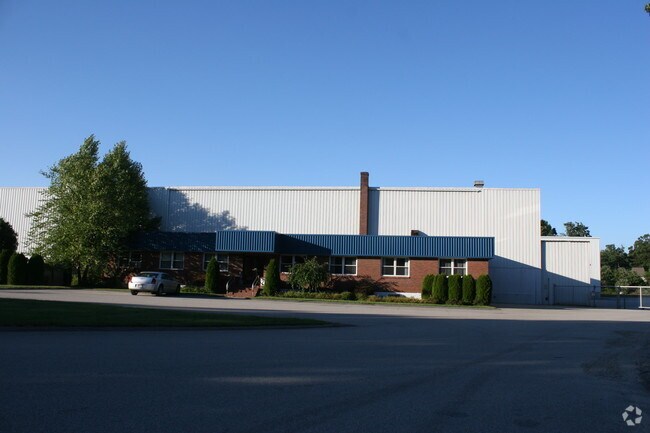
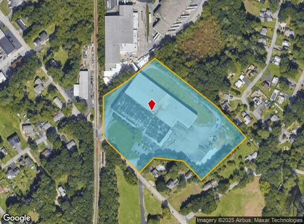
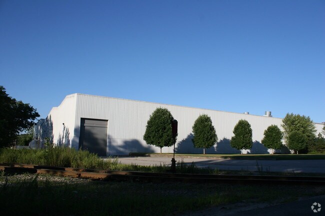
Property Record
27 Elm St, Auburn, MA 01501
NEARBY LISTINGS FOR SALE OR LEASE
Property Detail
27 Elm St
AUBU-000058-000000-000048
Worcester
Manufacturinglight
Massachusetts
X
48
25027C0804E
8.30 AC
2025
Outlying Worcester
2025
Boston
736500
Worcester, MA-CT
104,482 SF
DEMOGRAPHICS near 27 Elm St
1 Mile
3 Mile
5 Mile
2024 Total Population
3,189
26,286
118,314
2029 Population
3,210
26,296
117,071
Pop Growth 2024-2029
+ 0.66%
+ 0.04%
(1.05%)
Average Age
46
43
39
2024 Total Households
1,343
10,672
45,263
HH Growth 2024-2029
+ 0.60%
+ 0.03%
(1.01%)
Median Household Inc
$111,961
$93,321
$67,687
Avg Household Size
2.30
2.40
2.40
2024 Avg HH Vehicles
2.00
2.00
2.00
Median Home Value
$337,078
$345,758
$326,764
Median Year Built
1965
1961
1953
Nearby Places
Map Layers
Map Styles
 Street
 Aerial
- Restaurants
- Banks
- Shops
- Fitness
- Groceries
PUBLIC TRANSPORTATION
COMMUTER RAIL
Worcester Union Station (Lake Shore Limited - Amtrak)
DRIVE
WALK
Distance
Worcester Union Station (Lake Shore Limited - Amtrak)
12 min
6.5 mi
Worcester (Framingham/Worcester Line - Massachusetts Bay Transportation Authority Commuter Rail (Purple Line))
DRIVE
WALK
Distance
Worcester (Framingham/Worcester Line - Massachusetts Bay Transportation Authority Commuter Rail (Purple Line))
12 min
6.7 mi
AIRPORT
Worcester Regional
DRIVE
WALK
Distance
Worcester Regional
20 min
8.4 mi
Freight Ports
Port of Boston
DRIVE
WALK
Distance
Port of Boston
62 min
46.3 mi
Nearby Properties
Address
Land Use
TOTAL SIZE
Lot Size
Zoning
Address
Land Use
TOTAL SIZE
Lot Size
Zoning
25,000 SF
99.10 AC
MG-.5
Address
Land Use
TOTAL SIZE
Lot Size
Zoning
164,378 SF
21.40 AC
Address
Land Use
TOTAL SIZE
Lot Size
Zoning
118,112 SF
6.54 AC
Address
Land Use
TOTAL SIZE
Lot Size
Zoning
36.67 AC
Address
Land Use
TOTAL SIZE
Lot Size
Zoning
279,977 SF
17.80 AC
Address
Land Use
TOTAL SIZE
Lot Size
Zoning
92,604 SF
1 AC
Address
Land Use
TOTAL SIZE
Lot Size
Zoning
210,001 SF
13.14 AC
Address
Land Use
TOTAL SIZE
Lot Size
Zoning
70,400 SF
17.10 AC
Address
Land Use
TOTAL SIZE
Lot Size
Zoning
8.77 AC
BL-1
Address
Land Use
TOTAL SIZE
Lot Size
Zoning
151.20 AC
Address
Land Use
TOTAL SIZE
Lot Size
Zoning
13,417 SF
28.90 AC
MG-.5
Address
Land Use
TOTAL SIZE
Lot Size
Zoning
169,822 SF
18.80 AC
RL-7
Address
Land Use
TOTAL SIZE
Lot Size
Zoning
21.72 AC
Address
Land Use
TOTAL SIZE
Lot Size
Zoning
71,622 SF
33.28 AC
Address
Land Use
TOTAL SIZE
Lot Size
Zoning
199,424 SF
12.97 AC
ML-.5
Address
Land Use
TOTAL SIZE
Lot Size
Zoning
116,919 SF
17.60 AC
Address
Land Use
TOTAL SIZE
Lot Size
Zoning
42.81 AC
Address
Land Use
TOTAL SIZE
Lot Size
Zoning
2.62 AC
RG-5
Address
Land Use
TOTAL SIZE
Lot Size
Zoning
107,484 SF
11.70 AC
Address
Land Use
TOTAL SIZE
Lot Size
Zoning
56,190 SF
12.90 AC
Address
Land Use
TOTAL SIZE
Lot Size
Zoning
105,000 SF
6.43 AC
RG-5
Address
Land Use
TOTAL SIZE
Lot Size
Zoning
40,174 SF
5.20 AC
Address
Land Use
TOTAL SIZE
Lot Size
Zoning
136,816 SF
9.09 AC
MG-2
Address
Land Use
TOTAL SIZE
Lot Size
Zoning
6,868 SF
4.57 AC
MG-.5
Address
Land Use
TOTAL SIZE
Lot Size
Zoning
11.30 AC
Address
Land Use
TOTAL SIZE
Lot Size
Zoning
121,540 SF
6.14 AC
Address
Land Use
TOTAL SIZE
Lot Size
Zoning
64,260 SF
7.30 AC
Address
Land Use
TOTAL SIZE
Lot Size
Zoning
54,498 SF
6 AC
Address
Land Use
TOTAL SIZE
Lot Size
Zoning
61,295 SF
4.71 AC
ML-.5
Address
Land Use
TOTAL SIZE
Lot Size
Zoning
115,521 SF
7.71 AC
ML-.5
The World's #1 Commercial Real Estate Marketplace
Connect with us
© 2025 CoStar Group
The information above has been obtained from sources believed reliable. While we do not doubt its accuracy we have not verified it and make no guarantee, warranty or representation about it. It is your responsibility to independently confirm its accuracy and completeness. Any projections, opinions, assumptions, or estimates used are for example only and do not represent the current or future performance of the property. The value of this transaction to you depends on tax and other factors which should be evaluated by your tax, financial, and legal advisors. You and your advisors should conduct a careful, independent investigation of the property to determine to your satisfaction the suitability of the property for your needs.