Property Record
27 Golf Crest Dr, Acworth, GA 30101
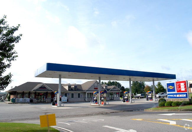


Property Detail
27 Golf Crest Dr
031.2.3.042.0000
REAL PROPERTY
Storebuilding
Paulding
B2
Georgia
B and X Area of moderate flood hazard, usually the area between the limits of the 100-year and 500-year floods.
320
2025
1.50 AC
2025
Paulding Cnty/Dallas
120107
Atlanta
7,160 SF
Atlanta-Sandy Springs-Roswell, GA
NEARBY LISTINGS FOR SALE OR LEASE
DEMOGRAPHICS near 27 Golf Crest Dr
1 mile
3 mile
5 mile
2025 Total Population
5,694
30,960
69,467
2030 Population
6,239
33,884
75,045
Pop Growth 2025-2030
+ 9.57%
+ 9.44%
+ 8.03%
Average Age
39
38
39
2025 Total Households
1,740
9,763
22,649
HH Growth 2025-2030
+ 9.60%
+ 9.39%
+ 7.93%
Median Household Inc
$144,539
$127,458
$125,654
Avg Household Size
3.30
3.10
3.00
2025 Avg HH Vehicles
2.00
2.00
2.00
Median Home Value
$482,715
$441,234
$439,128
Median Year Built
2006
2006
2003
Nearby Places
Map Layers
Map Styles
 Street
 Aerial
Layers
 Traffic
 Biking
Places
Listings with unknown addresses are not visible on the map
- Restaurants
- Banks
- Shops
- Fitness
- Groceries
PUBLIC TRANSPORTATION
AIRPORT
Hartsfield - Jackson Atlanta International
Drive
Walk
Distance
Hartsfield - Jackson Atlanta International
63 min
44.0 mi
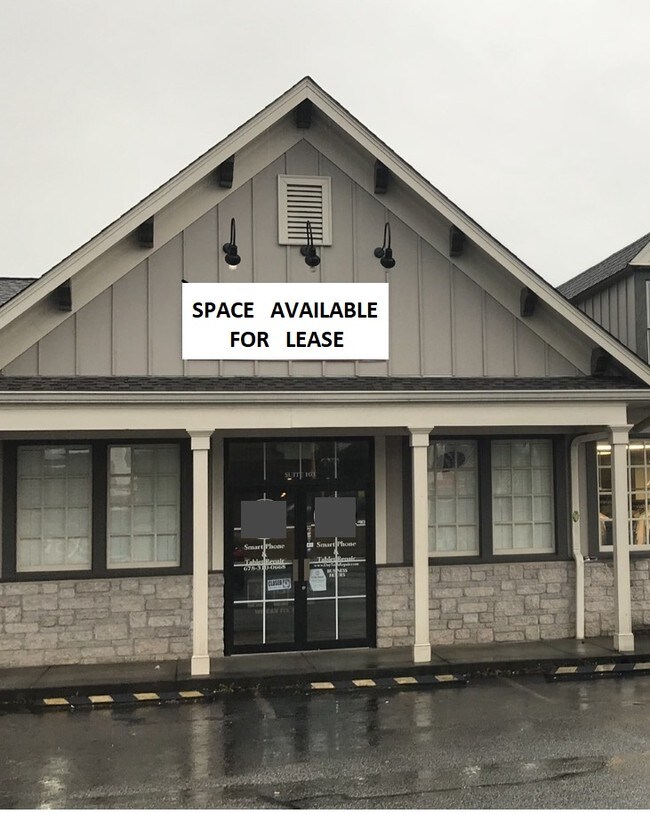
SALE & LEASE HISTORY
LISTING DATE
SALE/LEASE

Sep 25, 2016
For Lease
Mar 12, 2019
For Lease
Nearby Properties
Address
Land Use
TOTAL SIZE
Lot Size
Zoning
Address
Land Use
TOTAL SIZE
Lot Size
Zoning
103.29 AC
PRD-100
Address
Land Use
TOTAL SIZE
Lot Size
Zoning
Address
Land Use
TOTAL SIZE
Lot Size
Zoning
Address
Land Use
TOTAL SIZE
Lot Size
Zoning
90.96 AC
Address
Land Use
TOTAL SIZE
Lot Size
Zoning
71,175 SF
30.37 AC
Address
Land Use
TOTAL SIZE
Lot Size
Zoning
69,376 SF
8.52 AC
GC
Address
Land Use
TOTAL SIZE
Lot Size
Zoning
78,984 SF
17.01 AC
B1
Address
Land Use
TOTAL SIZE
Lot Size
Zoning
70,038 SF
8.67 AC
B2
Address
Land Use
TOTAL SIZE
Lot Size
Zoning
30,804 SF
2.29 AC
B2
Address
Land Use
TOTAL SIZE
Lot Size
Zoning
47,728 SF
5.45 AC
GC/WS
Address
Land Use
TOTAL SIZE
Lot Size
Zoning
31.69 AC
Address
Land Use
TOTAL SIZE
Lot Size
Zoning
38,652 SF
1.07 AC
B1
Address
Land Use
TOTAL SIZE
Lot Size
Zoning
33,374 SF
5.69 AC
B1
Address
Land Use
TOTAL SIZE
Lot Size
Zoning
30,600 SF
4.28 AC
B2
Address
Land Use
TOTAL SIZE
Lot Size
Zoning
58,100 SF
6.74 AC
B2
Address
Land Use
TOTAL SIZE
Lot Size
Zoning
18,376 SF
5 AC
GC
Address
Land Use
TOTAL SIZE
Lot Size
Zoning
13,546 SF
1.49 AC
NB
Address
Land Use
TOTAL SIZE
Lot Size
Zoning
2,968 SF
24.61 AC
A1
Address
Land Use
TOTAL SIZE
Lot Size
Zoning
2,226 SF
10.61 AC
Address
Land Use
TOTAL SIZE
Lot Size
Zoning
15,061 SF
16.55 AC
GC
Address
Land Use
TOTAL SIZE
Lot Size
Zoning
14,490 SF
1.65 AC
GC/WS
Address
Land Use
TOTAL SIZE
Lot Size
Zoning
17,253 SF
3.45 AC
B1
Address
Land Use
TOTAL SIZE
Lot Size
Zoning
7.13 AC
C1
Address
Land Use
TOTAL SIZE
Lot Size
Zoning
31,307 SF
5.84 AC
Address
Land Use
TOTAL SIZE
Lot Size
Zoning
16,250 SF
2.34 AC
B1
Address
Land Use
TOTAL SIZE
Lot Size
Zoning
80,550 SF
7.87 AC
B2
Address
Land Use
TOTAL SIZE
Lot Size
Zoning
32,223 SF
3.91 AC
B2
Address
Land Use
TOTAL SIZE
Lot Size
Zoning
17,610 SF
2.47 AC
B2
Address
Land Use
TOTAL SIZE
Lot Size
Zoning
20,940 SF
4.15 AC
B1
Address
Land Use
TOTAL SIZE
Lot Size
Zoning
14,438 SF
1.59 AC
B1
The World's #1 Commercial Real Estate Marketplace
Connect with us
© 2026 CoStar Group
The information above has been obtained from sources believed reliable. While we do not doubt its accuracy we have not verified it and make no guarantee, warranty or representation about it. It is your responsibility to independently confirm its accuracy and completeness. Any projections, opinions, assumptions, or estimates used are for example only and do not represent the current or future performance of the property. The value of this transaction to you depends on tax and other factors which should be evaluated by your tax, financial, and legal advisors. You and your advisors should conduct a careful, independent investigation of the property to determine to your satisfaction the suitability of the property for your needs.