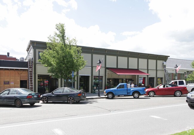
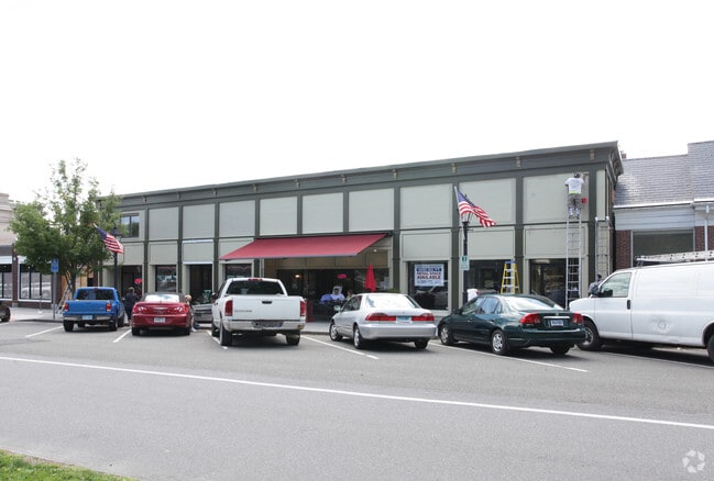
Property Record
27 Main St, Northfield, CT 06778
NEARBY LISTINGS FOR SALE OR LEASE
-
-
View all Northfield listings for lease on LoopNet.com
Property Detail
27 Main St
Torrington, CT
Litchfield
LITC-000245-000016-000010
Connecticut
Duplex
1
2024
0.50 AC
2025
New Milford/SW Litchfield
360400
Hartford
2,488 SF
DEMOGRAPHICS near 27 Main St
1 mile
3 mile
5 mile
2024 Total Population
6,082
19,488
30,827
2029 Population
6,033
19,472
30,965
Pop Growth 2024-2029
(0.81%)
(0.08%)
+ 0.45%
Average Age
41
42
43
2024 Total Households
2,622
7,699
12,206
HH Growth 2024-2029
(0.80%)
(0.10%)
+ 0.47%
Median Household Inc
$65,368
$86,019
$95,911
Avg Household Size
2.30
2.50
2.50
2024 Avg HH Vehicles
2.00
2.00
2.00
Median Home Value
$301,534
$341,792
$369,867
Median Year Built
1969
1975
1974
Nearby Places
Map Layers
Map Styles
 Street
 Aerial
Transit
 Traffic
 Biking
Places
Listings with unknown addresses are not visible on the map
- Restaurants
- Banks
- Shops
- Fitness
- Groceries
PUBLIC TRANSPORTATION
AIRPORT
Tweed/New Haven
Drive
Walk
Distance
Tweed/New Haven
61 min
39.3 mi
Bradley International
Drive
Walk
Distance
Bradley International
71 min
40.7 mi
Freight Ports
Port of New Haven
Drive
Walk
Distance
Port of New Haven
56 min
36.5 mi
SALE & LEASE HISTORY
LISTING DATE
SALE/LEASE

Jan 18, 2023
For Lease
Nearby Properties
Address
Land Use
TOTAL SIZE
Lot Size
Zoning
Address
Land Use
TOTAL SIZE
Lot Size
Zoning
65,974 SF
20.70 AC
RA15
Address
Land Use
TOTAL SIZE
Lot Size
Zoning
1,154 SF
435 AC
R90
Address
Land Use
TOTAL SIZE
Lot Size
Zoning
18,252 SF
1.56 AC
GC
Address
Land Use
TOTAL SIZE
Lot Size
Zoning
17,085 SF
3.77 AC
RR
Address
Land Use
TOTAL SIZE
Lot Size
Zoning
12.44 AC
M2
Address
Land Use
TOTAL SIZE
Lot Size
Zoning
411 AC
RR
Address
Land Use
TOTAL SIZE
Lot Size
Zoning
16,867 SF
7.94 AC
RA15GC
Address
Land Use
TOTAL SIZE
Lot Size
Zoning
11,920 SF
4.20 AC
RA15
Address
Land Use
TOTAL SIZE
Lot Size
Zoning
37.72 AC
RA80A
Address
Land Use
TOTAL SIZE
Lot Size
Zoning
9,594 SF
1.87 AC
GC
Address
Land Use
TOTAL SIZE
Lot Size
Zoning
2.30 AC
GC
Address
Land Use
TOTAL SIZE
Lot Size
Zoning
130,374 SF
10.50 AC
M2
Address
Land Use
TOTAL SIZE
Lot Size
Zoning
5,661 SF
93.46 AC
RR
Address
Land Use
TOTAL SIZE
Lot Size
Zoning
6.55 AC
M1
Address
Land Use
TOTAL SIZE
Lot Size
Zoning
11,067 SF
1.69 AC
M1
Address
Land Use
TOTAL SIZE
Lot Size
Zoning
7.47 AC
M2
Address
Land Use
TOTAL SIZE
Lot Size
Zoning
201.84 AC
RA80A
Address
Land Use
TOTAL SIZE
Lot Size
Zoning
9.16 AC
GC
Address
Land Use
TOTAL SIZE
Lot Size
Zoning
15,763 SF
2.32 AC
M1
Address
Land Use
TOTAL SIZE
Lot Size
Zoning
4,520 SF
1.49 AC
GC
Address
Land Use
TOTAL SIZE
Lot Size
Zoning
47.49 AC
RR
Address
Land Use
TOTAL SIZE
Lot Size
Zoning
8,533 SF
4.11 AC
RR
Address
Land Use
TOTAL SIZE
Lot Size
Zoning
4,820 SF
38.38 AC
RR
Address
Land Use
TOTAL SIZE
Lot Size
Zoning
18.24 AC
RA80
Address
Land Use
TOTAL SIZE
Lot Size
Zoning
165.60 AC
RA15
Address
Land Use
TOTAL SIZE
Lot Size
Zoning
4,044 SF
45.54 AC
RR
Address
Land Use
TOTAL SIZE
Lot Size
Zoning
6,838 SF
12.55 AC
RR
Address
Land Use
TOTAL SIZE
Lot Size
Zoning
1.92 AC
M1
Address
Land Use
TOTAL SIZE
Lot Size
Zoning
4,804 SF
16 AC
RR
Address
Land Use
TOTAL SIZE
Lot Size
Zoning
3,080 SF
0.50 AC
SF
The World's #1 Commercial Real Estate Marketplace
Connect with us
© 2026 CoStar Group
The information above has been obtained from sources believed reliable. While we do not doubt its accuracy we have not verified it and make no guarantee, warranty or representation about it. It is your responsibility to independently confirm its accuracy and completeness. Any projections, opinions, assumptions, or estimates used are for example only and do not represent the current or future performance of the property. The value of this transaction to you depends on tax and other factors which should be evaluated by your tax, financial, and legal advisors. You and your advisors should conduct a careful, independent investigation of the property to determine to your satisfaction the suitability of the property for your needs.