Property Record
27 Midstate Dr, Auburn, MA 01501
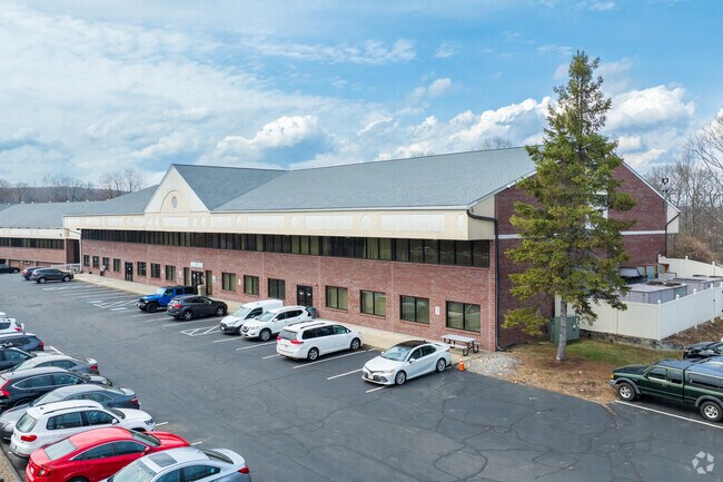

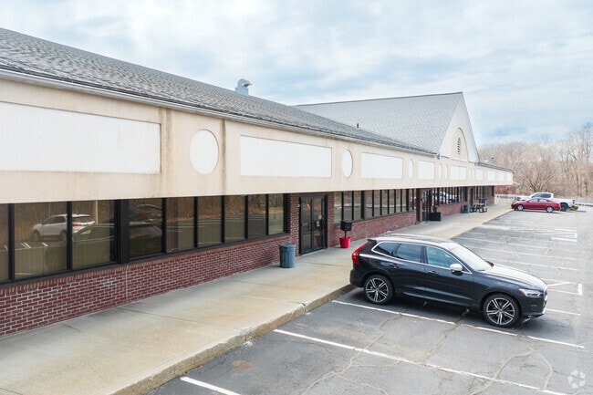
Property Detail
27 Midstate Dr
Worcester, MA
Worcester
AUBU-000047-000000-000075
Massachusetts
Commercialnec
75
B and X Area of moderate flood hazard, usually the area between the limits of the 100-year and 500-year floods.
2.60 AC
2025
Outlying Worcester
2025
Boston
736100
NEARBY LISTINGS FOR SALE OR LEASE
DEMOGRAPHICS near 27 Midstate Dr
1 mile
3 mile
5 mile
2025 Total Population
3,364
22,969
95,551
2030 Population
3,482
23,649
97,251
Pop Growth 2025-2030
+ 3.51%
+ 2.96%
+ 1.78%
Average Age
44
44
41
2025 Total Households
1,361
9,317
37,478
HH Growth 2025-2030
+ 3.67%
+ 3.09%
+ 1.93%
Median Household Inc
$113,888
$101,857
$81,396
Avg Household Size
2.40
2.40
2.40
2025 Avg HH Vehicles
2.00
2.00
2.00
Median Home Value
$391,666
$393,906
$387,499
Median Year Built
1958
1963
1955
Nearby Places
Map Layers
Map Styles
 Street
 Aerial
Layers
 Traffic
 Biking
Places
Listings with unknown addresses are not visible on the map
- Restaurants
- Banks
- Shops
- Fitness
- Groceries
PUBLIC TRANSPORTATION
COMMUTER RAIL
Drive
Walk
Distance
12 min
7.0 mi
Worcester (Framingham/Worcester Line - Massachusetts Bay Transportation Authority Commuter Rail (Purple Line))
Drive
Walk
Distance
Worcester (Framingham/Worcester Line - Massachusetts Bay Transportation Authority Commuter Rail (Purple Line))
13 min
7.3 mi
AIRPORT
Worcester Regional
Drive
Walk
Distance
Worcester Regional
20 min
8.4 mi
Rhode Island Tf Green International
Drive
Walk
Distance
Rhode Island Tf Green International
67 min
49.0 mi
Freight Ports
Port of Boston
Drive
Walk
Distance
Port of Boston
64 min
47.7 mi
SALE & LEASE HISTORY
LISTING DATE
SALE/LEASE

Sep 15, 2020
For Lease
Oct 10, 2018
For Lease
Dec 28, 2017
For Lease
Apr 10, 2020
For Lease
Nearby Properties
Address
Land Use
TOTAL SIZE
Lot Size
Zoning
Address
Land Use
TOTAL SIZE
Lot Size
Zoning
164,378 SF
21.40 AC
Address
Land Use
TOTAL SIZE
Lot Size
Zoning
118,112 SF
6.54 AC
Address
Land Use
TOTAL SIZE
Lot Size
Zoning
41.84 AC
Address
Land Use
TOTAL SIZE
Lot Size
Zoning
36.67 AC
Address
Land Use
TOTAL SIZE
Lot Size
Zoning
92,604 SF
1 AC
Address
Land Use
TOTAL SIZE
Lot Size
Zoning
210,001 SF
13.14 AC
Address
Land Use
TOTAL SIZE
Lot Size
Zoning
70,400 SF
17.10 AC
Address
Land Use
TOTAL SIZE
Lot Size
Zoning
267,600 SF
45.87 AC
R2
Address
Land Use
TOTAL SIZE
Lot Size
Zoning
21.72 AC
Address
Land Use
TOTAL SIZE
Lot Size
Zoning
124,100 SF
5.03 AC
RG-5
Address
Land Use
TOTAL SIZE
Lot Size
Zoning
116,919 SF
17.60 AC
Address
Land Use
TOTAL SIZE
Lot Size
Zoning
42.81 AC
Address
Land Use
TOTAL SIZE
Lot Size
Zoning
107,484 SF
11.70 AC
Address
Land Use
TOTAL SIZE
Lot Size
Zoning
56,190 SF
12.90 AC
Address
Land Use
TOTAL SIZE
Lot Size
Zoning
145,401 SF
23.20 AC
GB
Address
Land Use
TOTAL SIZE
Lot Size
Zoning
175,701 SF
25.85 AC
HB2
Address
Land Use
TOTAL SIZE
Lot Size
Zoning
40,174 SF
5.20 AC
Address
Land Use
TOTAL SIZE
Lot Size
Zoning
11.30 AC
Address
Land Use
TOTAL SIZE
Lot Size
Zoning
121,540 SF
6.14 AC
Address
Land Use
TOTAL SIZE
Lot Size
Zoning
64,260 SF
7.30 AC
Address
Land Use
TOTAL SIZE
Lot Size
Zoning
54,498 SF
6 AC
Address
Land Use
TOTAL SIZE
Lot Size
Zoning
15,585 SF
6.40 AC
Address
Land Use
TOTAL SIZE
Lot Size
Zoning
11.11 AC
Address
Land Use
TOTAL SIZE
Lot Size
Zoning
3.73 AC
Address
Land Use
TOTAL SIZE
Lot Size
Zoning
77,606 SF
3.04 AC
Address
Land Use
TOTAL SIZE
Lot Size
Zoning
100,640 SF
7.30 AC
Address
Land Use
TOTAL SIZE
Lot Size
Zoning
7,000 SF
20.84 AC
I
Address
Land Use
TOTAL SIZE
Lot Size
Zoning
53,096 SF
5.60 AC
Address
Land Use
TOTAL SIZE
Lot Size
Zoning
50,065 SF
8.65 AC
R3
Address
Land Use
TOTAL SIZE
Lot Size
Zoning
5.80 AC
The World's #1 Commercial Real Estate Marketplace
Connect with us
© 2026 CoStar Group
The information above has been obtained from sources believed reliable. While we do not doubt its accuracy we have not verified it and make no guarantee, warranty or representation about it. It is your responsibility to independently confirm its accuracy and completeness. Any projections, opinions, assumptions, or estimates used are for example only and do not represent the current or future performance of the property. The value of this transaction to you depends on tax and other factors which should be evaluated by your tax, financial, and legal advisors. You and your advisors should conduct a careful, independent investigation of the property to determine to your satisfaction the suitability of the property for your needs.