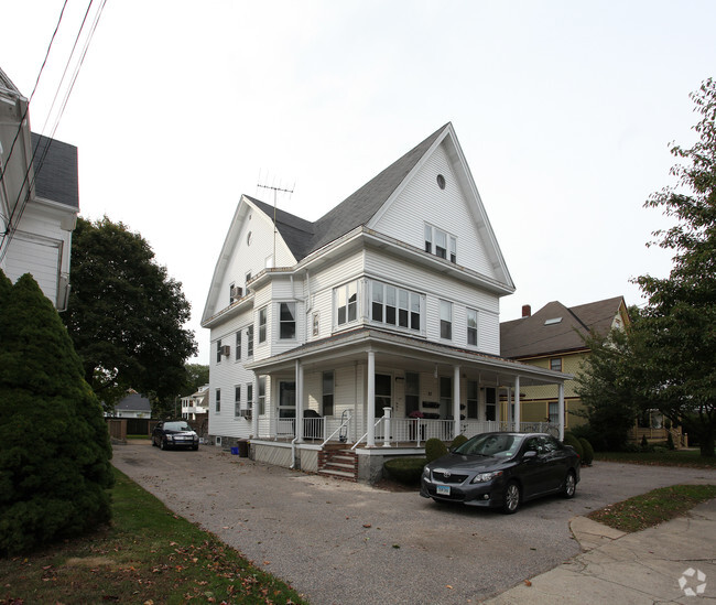
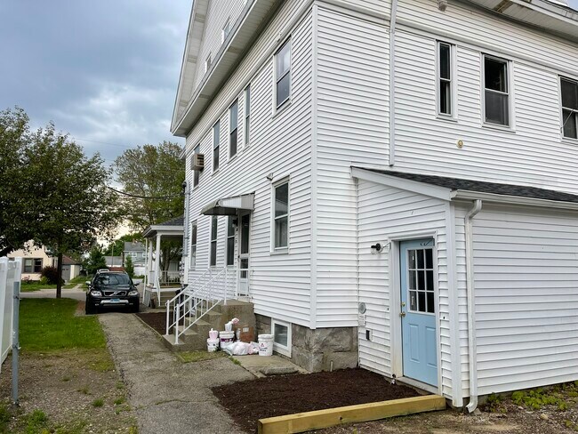
Property Record
27 Moss St, Pawcatuck, CT 06379

NEARBY LISTINGS FOR SALE OR LEASE
-
-
View all Pawcatuck listings for sale on LoopNet.com
Property Detail
27 Moss St
STON-000004-000003-000023
New London
Apartmenthouse5plusunits
Connecticut
X
23
44009C0252K
0.23 AC
2025
Southeast New London
2025
Hartford
705101
Norwich-New London-Willimantic, CT
3,507 SF
DEMOGRAPHICS near 27 Moss St
1 mile
3 mile
5 mile
2024 Total Population
8,488
23,408
37,167
2029 Population
8,317
23,108
37,237
Pop Growth 2024-2029
(2.01%)
(1.28%)
+ 0.19%
Average Age
43
44
46
2024 Total Households
3,947
10,308
16,408
HH Growth 2024-2029
(2.28%)
(1.53%)
+ 0.19%
Median Household Inc
$62,605
$79,657
$88,339
Avg Household Size
2.10
2.20
2.20
2024 Avg HH Vehicles
2.00
2.00
2.00
Median Home Value
$318,151
$363,263
$390,187
Median Year Built
1952
1969
1968
Nearby Places
Map Layers
Map Styles
 Street
 Aerial
Transit
 Traffic
 Biking
Places
Listings with unknown addresses are not visible on the map
- Restaurants
- Banks
- Shops
- Fitness
- Groceries
PUBLIC TRANSPORTATION
COMMUTER RAIL
Mystic Amtrak (Northeast Regional - Amtrak)
Drive
Walk
Distance
Mystic Amtrak (Northeast Regional - Amtrak)
8 min
4.4 mi
Westerly Amtrak Station (Northeast Regional - Amtrak)
Drive
Walk
Distance
Westerly Amtrak Station (Northeast Regional - Amtrak)
10 min
5.6 mi
Freight Ports
Port of Davisville, RI
Drive
Walk
Distance
Port of Davisville, RI
62 min
43.2 mi
SALE & LEASE HISTORY
LISTING DATE
SALE/LEASE

Sep 23, 2016
For Sale
Jun 12, 2024
For Sale
Nearby Properties
Address
Land Use
TOTAL SIZE
Lot Size
Zoning
Address
Land Use
TOTAL SIZE
Lot Size
Zoning
181,967 SF
143 AC
RR-80
Address
Land Use
TOTAL SIZE
Lot Size
Zoning
5.23 AC
Address
Land Use
TOTAL SIZE
Lot Size
Zoning
32.59 AC
RA-40
Address
Land Use
TOTAL SIZE
Lot Size
Zoning
7,806 SF
3.19 AC
Address
Land Use
TOTAL SIZE
Lot Size
Zoning
7,958 SF
2.65 AC
Address
Land Use
TOTAL SIZE
Lot Size
Zoning
5,771 SF
0.54 AC
Address
Land Use
TOTAL SIZE
Lot Size
Zoning
6,779 SF
0.96 AC
Address
Land Use
TOTAL SIZE
Lot Size
Zoning
6,006 SF
1.32 AC
Address
Land Use
TOTAL SIZE
Lot Size
Zoning
10,811 SF
4.57 AC
Address
Land Use
TOTAL SIZE
Lot Size
Zoning
2.74 AC
Address
Land Use
TOTAL SIZE
Lot Size
Zoning
5,142 SF
1.06 AC
Address
Land Use
TOTAL SIZE
Lot Size
Zoning
8,166 SF
2.25 AC
Address
Land Use
TOTAL SIZE
Lot Size
Zoning
3,916 SF
1.37 AC
Address
Land Use
TOTAL SIZE
Lot Size
Zoning
74,328 SF
19.50 AC
RR-80
Address
Land Use
TOTAL SIZE
Lot Size
Zoning
2.62 AC
Address
Land Use
TOTAL SIZE
Lot Size
Zoning
8,588 SF
1.12 AC
Address
Land Use
TOTAL SIZE
Lot Size
Zoning
6,030 SF
1.01 AC
Address
Land Use
TOTAL SIZE
Lot Size
Zoning
5,776 SF
0.72 AC
Address
Land Use
TOTAL SIZE
Lot Size
Zoning
0.70 AC
Address
Land Use
TOTAL SIZE
Lot Size
Zoning
1.43 AC
Address
Land Use
TOTAL SIZE
Lot Size
Zoning
5,929 SF
1.39 AC
Address
Land Use
TOTAL SIZE
Lot Size
Zoning
2.72 AC
Address
Land Use
TOTAL SIZE
Lot Size
Zoning
0.76 AC
Address
Land Use
TOTAL SIZE
Lot Size
Zoning
4.71 AC
Address
Land Use
TOTAL SIZE
Lot Size
Zoning
3.08 AC
Address
Land Use
TOTAL SIZE
Lot Size
Zoning
9,684 SF
3.60 AC
Address
Land Use
TOTAL SIZE
Lot Size
Zoning
6,765 SF
1.48 AC
Address
Land Use
TOTAL SIZE
Lot Size
Zoning
4,291 SF
0.66 AC
Address
Land Use
TOTAL SIZE
Lot Size
Zoning
5,823 SF
1.09 AC
Address
Land Use
TOTAL SIZE
Lot Size
Zoning
5,343 SF
0.73 AC
The World's #1 Commercial Real Estate Marketplace
Connect with us
© 2026 CoStar Group
The information above has been obtained from sources believed reliable. While we do not doubt its accuracy we have not verified it and make no guarantee, warranty or representation about it. It is your responsibility to independently confirm its accuracy and completeness. Any projections, opinions, assumptions, or estimates used are for example only and do not represent the current or future performance of the property. The value of this transaction to you depends on tax and other factors which should be evaluated by your tax, financial, and legal advisors. You and your advisors should conduct a careful, independent investigation of the property to determine to your satisfaction the suitability of the property for your needs.