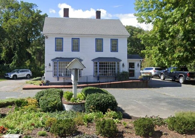
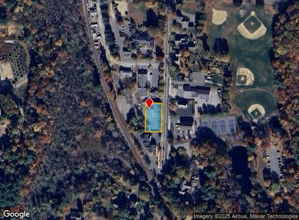
Property Record
27 N Main St, Sherborn, MA 01770
NEARBY LISTINGS FOR SALE OR LEASE
Property Detail
27 N Main St
SHER-000011-000000-000046
Middlesex
Commercialnec
Massachusetts
X
46
25017C0651F
0.50 AC
2025
Framingham/Natick
2025
Boston
386100
Boston-Cambridge-Newton, MA-NH
DEMOGRAPHICS near 27 N Main St
1 Mile
3 Mile
5 Mile
2024 Total Population
1,183
31,953
118,929
2029 Population
1,176
31,958
118,348
Pop Growth 2024-2029
(0.59%)
+ 0.02%
(0.49%)
Average Age
42
40
40
2024 Total Households
404
12,164
44,184
HH Growth 2024-2029
(0.74%)
(0.29%)
(0.66%)
Median Household Inc
$221,239
$98,159
$113,185
Avg Household Size
2.90
2.60
2.60
2024 Avg HH Vehicles
2.00
2.00
2.00
Median Home Value
$861,814
$713,759
$664,244
Median Year Built
1967
1970
1966
Nearby Places
Map Layers
Map Styles
 Street
 Aerial
- Restaurants
- Banks
- Shops
- Fitness
- Groceries
PUBLIC TRANSPORTATION
COMMUTER RAIL
Natick (Framingham/Worcester Line - Massachusetts Bay Transportation Authority Commuter Rail (Purple Line))
DRIVE
WALK
Distance
Natick (Framingham/Worcester Line - Massachusetts Bay Transportation Authority Commuter Rail (Purple Line))
7 min
3.2 mi
West Natick (Framingham/Worcester Line - Massachusetts Bay Transportation Authority Commuter Rail (Purple Line))
DRIVE
WALK
Distance
West Natick (Framingham/Worcester Line - Massachusetts Bay Transportation Authority Commuter Rail (Purple Line))
8 min
3.7 mi
AIRPORT
General Edward Lawrence Logan International
DRIVE
WALK
Distance
General Edward Lawrence Logan International
39 min
23.4 mi
Worcester Regional
DRIVE
WALK
Distance
Worcester Regional
54 min
30.1 mi
Freight Ports
Port of Boston
DRIVE
WALK
Distance
Port of Boston
38 min
21.8 mi
Nearby Properties
Address
Land Use
TOTAL SIZE
Lot Size
Zoning
Address
Land Use
TOTAL SIZE
Lot Size
Zoning
188,746 SF
46.90 AC
RSA
Address
Land Use
TOTAL SIZE
Lot Size
Zoning
315,055 SF
40.38 AC
G
Address
Land Use
TOTAL SIZE
Lot Size
Zoning
20,704 SF
13.36 AC
PCD
Address
Land Use
TOTAL SIZE
Lot Size
Zoning
199,320 SF
16.65 AC
RSA
Address
Land Use
TOTAL SIZE
Lot Size
Zoning
108.84 AC
M
Address
Land Use
TOTAL SIZE
Lot Size
Zoning
251,366 SF
14.42 AC
G
Address
Land Use
TOTAL SIZE
Lot Size
Zoning
140,695 SF
2.52 AC
G
Address
Land Use
TOTAL SIZE
Lot Size
Zoning
39,840 SF
17.20 AC
G
Address
Land Use
TOTAL SIZE
Lot Size
Zoning
61,866 SF
9.40 AC
G
Address
Land Use
TOTAL SIZE
Lot Size
Zoning
35,080 SF
8.29 AC
G
Address
Land Use
TOTAL SIZE
Lot Size
Zoning
87.30 AC
A
Address
Land Use
TOTAL SIZE
Lot Size
Zoning
53,878 SF
24.98 AC
RSB
Address
Land Use
TOTAL SIZE
Lot Size
Zoning
189.70 AC
RSB
Address
Land Use
TOTAL SIZE
Lot Size
Zoning
78.50 AC
R2
Address
Land Use
TOTAL SIZE
Lot Size
Zoning
60,088 SF
0.36 AC
DM
Address
Land Use
TOTAL SIZE
Lot Size
Zoning
187,411 SF
29.56 AC
H
Address
Land Use
TOTAL SIZE
Lot Size
Zoning
58,053 SF
22.07 AC
R4
Address
Land Use
TOTAL SIZE
Lot Size
Zoning
5.96 AC
M
Address
Land Use
TOTAL SIZE
Lot Size
Zoning
1,039 SF
3.31 AC
RM
Address
Land Use
TOTAL SIZE
Lot Size
Zoning
5,280 SF
8.92 AC
G
Address
Land Use
TOTAL SIZE
Lot Size
Zoning
57,072 SF
28.96 AC
RSC
Address
Land Use
TOTAL SIZE
Lot Size
Zoning
9,032 SF
10 AC
RSA
Address
Land Use
TOTAL SIZE
Lot Size
Zoning
30,869 SF
0.45 AC
DM
Address
Land Use
TOTAL SIZE
Lot Size
Zoning
45,676 SF
0.57 AC
DM
Address
Land Use
TOTAL SIZE
Lot Size
Zoning
11.65 AC
R2
Address
Land Use
TOTAL SIZE
Lot Size
Zoning
52,288 SF
4.65 AC
RSA
Address
Land Use
TOTAL SIZE
Lot Size
Zoning
26,485 SF
65.37 AC
R4
Address
Land Use
TOTAL SIZE
Lot Size
Zoning
25,724 SF
0.30 AC
DM
Address
Land Use
TOTAL SIZE
Lot Size
Zoning
26,227 SF
1.30 AC
DM
Address
Land Use
TOTAL SIZE
Lot Size
Zoning
29,280 SF
0.74 AC
G
The World's #1 Commercial Real Estate Marketplace
Connect with us
© 2025 CoStar Group
The information above has been obtained from sources believed reliable. While we do not doubt its accuracy we have not verified it and make no guarantee, warranty or representation about it. It is your responsibility to independently confirm its accuracy and completeness. Any projections, opinions, assumptions, or estimates used are for example only and do not represent the current or future performance of the property. The value of this transaction to you depends on tax and other factors which should be evaluated by your tax, financial, and legal advisors. You and your advisors should conduct a careful, independent investigation of the property to determine to your satisfaction the suitability of the property for your needs.