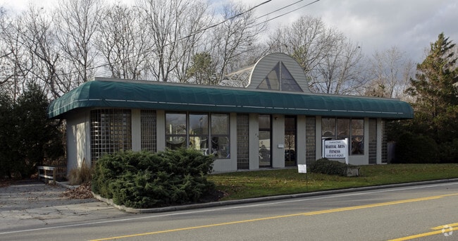
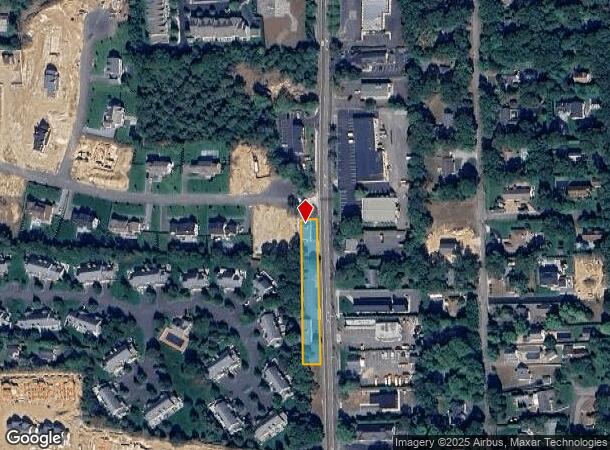
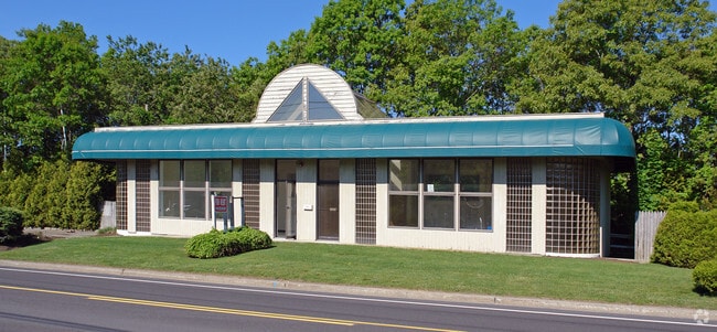
Property Record
27 Old Riverhead Rd, Hampton Bays, NY 11946
NEARBY LISTINGS FOR SALE OR LEASE
Property Detail
27 Old Riverhead Rd
0905-004-00-01-00-018-005
1988 FIN STRS +34001988 LL-600 IMP+60095 COMB LOT3 & 18.4 PER VILLG
Commercialnec
Suffolk
X
New York
36103C0759H
18
2024
0.48 AC
2024
Eastern Suffolk
190604
Long Island (New York)
3,248 SF
Nassau County-Suffolk County, NY
DEMOGRAPHICS near 27 Old Riverhead Rd
1 Mile
3 Mile
5 Mile
2024 Total Population
4,245
14,187
25,671
2029 Population
4,501
14,922
26,503
Pop Growth 2024-2029
+ 6.03%
+ 5.18%
+ 3.24%
Average Age
43
45
45
2024 Total Households
1,617
5,423
9,742
HH Growth 2024-2029
+ 6.12%
+ 5.48%
+ 3.34%
Median Household Inc
$112,892
$118,015
$115,768
Avg Household Size
2.60
2.50
2.60
2024 Avg HH Vehicles
2.00
2.00
2.00
Median Home Value
$832,205
$847,891
$801,320
Median Year Built
1979
1980
1979
Nearby Places
- Restaurants
- Banks
- Shops
- Fitness
- Groceries
PUBLIC TRANSPORTATION
COMMUTER RAIL
Westhampton Station (Montauk Branch - Long Island Rail Road)
DRIVE
WALK
Distance
Westhampton Station (Montauk Branch - Long Island Rail Road)
2 min
11 min
0.6 mi
Speonk Station (Montauk Branch - Long Island Rail Road)
DRIVE
WALK
Distance
Speonk Station (Montauk Branch - Long Island Rail Road)
6 min
3.6 mi
AIRPORT
Long Island MacArthur
DRIVE
WALK
Distance
Long Island MacArthur
41 min
26.6 mi
Freight Ports
Port of New Haven
DRIVE
WALK
Distance
Port of New Haven
157 min
67.2 mi
Nearby Properties
Address
Land Use
TOTAL SIZE
Lot Size
Zoning
Address
Land Use
TOTAL SIZE
Lot Size
Zoning
1,229.10 AC
LI200
Address
Land Use
TOTAL SIZE
Lot Size
Zoning
53,067 SF
6.20 AC
R2
Address
Land Use
TOTAL SIZE
Lot Size
Zoning
55,202 SF
18.50 AC
R2
Address
Land Use
TOTAL SIZE
Lot Size
Zoning
68,676 SF
9.70 AC
CR200
Address
Land Use
TOTAL SIZE
Lot Size
Zoning
11.41 AC
LI200
Address
Land Use
TOTAL SIZE
Lot Size
Zoning
18.28 AC
CR200
Address
Land Use
TOTAL SIZE
Lot Size
Zoning
8.26 AC
LI200
Address
Land Use
TOTAL SIZE
Lot Size
Zoning
15,084 SF
10.25 AC
R40
Address
Land Use
TOTAL SIZE
Lot Size
Zoning
31,393 SF
4.90 AC
R3
Address
Land Use
TOTAL SIZE
Lot Size
Zoning
26,824 SF
146.40 AC
CR200
Address
Land Use
TOTAL SIZE
Lot Size
Zoning
9,191 SF
14.39 AC
VILLA
Address
Land Use
TOTAL SIZE
Lot Size
Zoning
28,458 SF
9.60 AC
LI40
Address
Land Use
TOTAL SIZE
Lot Size
Zoning
28.62 AC
R40
Address
Land Use
TOTAL SIZE
Lot Size
Zoning
17,772 SF
8.86 AC
VILLA
Address
Land Use
TOTAL SIZE
Lot Size
Zoning
22,629 SF
2.10 AC
VILLA
Address
Land Use
TOTAL SIZE
Lot Size
Zoning
19.50 AC
PC
Address
Land Use
TOTAL SIZE
Lot Size
Zoning
20,697 SF
1.91 AC
B1
Address
Land Use
TOTAL SIZE
Lot Size
Zoning
36,918 SF
6.27 AC
R40
Address
Land Use
TOTAL SIZE
Lot Size
Zoning
13.90 AC
PC
Address
Land Use
TOTAL SIZE
Lot Size
Zoning
7,270 SF
4.20 AC
R2
Address
Land Use
TOTAL SIZE
Lot Size
Zoning
6,673 SF
4.50 AC
R20
Address
Land Use
TOTAL SIZE
Lot Size
Zoning
19,866 SF
14.37 AC
LI200
Address
Land Use
TOTAL SIZE
Lot Size
Zoning
28,544 SF
4.70 AC
R1
Address
Land Use
TOTAL SIZE
Lot Size
Zoning
16,854 SF
11.95 AC
OD
Address
Land Use
TOTAL SIZE
Lot Size
Zoning
92.10 AC
CR200
Address
Land Use
TOTAL SIZE
Lot Size
Zoning
6,720 SF
1.96 AC
VILLA
Address
Land Use
TOTAL SIZE
Lot Size
Zoning
20,822 SF
2.60 AC
B1
Address
Land Use
TOTAL SIZE
Lot Size
Zoning
6.42 AC
LI200
Address
Land Use
TOTAL SIZE
Lot Size
Zoning
1,792 SF
59.30 AC
RTPDD
Address
Land Use
TOTAL SIZE
Lot Size
Zoning
2,427 SF
3.80 AC
R3
The World's #1 Commercial Real Estate Marketplace
Connect with us
© 2025 CoStar Group
The information above has been obtained from sources believed reliable. While we do not doubt its accuracy we have not verified it and make no guarantee, warranty or representation about it. It is your responsibility to independently confirm its accuracy and completeness. Any projections, opinions, assumptions, or estimates used are for example only and do not represent the current or future performance of the property. The value of this transaction to you depends on tax and other factors which should be evaluated by your tax, financial, and legal advisors. You and your advisors should conduct a careful, independent investigation of the property to determine to your satisfaction the suitability of the property for your needs.