No Photo
Property Record
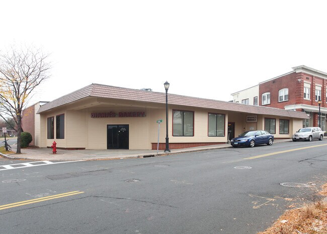
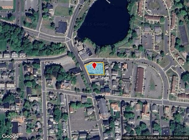
27 Pearl St, Enfield, CT 06082
Current Lease Availabilities
NEARBY LISTINGS FOR SALE OR LEASE
Property Detail
27 Pearl St
ENFI-000024-000000-000078
Hartford
Commercialbuilding
Connecticut
X
78
09003C0226F
0.42 AC
2025
Enfield
2025
Hartford
480800
Hartford-West Hartford-East Hartford, CT
14,771 SF
DEMOGRAPHICS near 27 Pearl St
1 Mile
3 Mile
5 Mile
2024 Total Population
9,453
36,507
80,944
2029 Population
9,473
36,439
80,317
Pop Growth 2024-2029
+ 0.21%
(0.19%)
(0.77%)
Average Age
38
42
43
2024 Total Households
3,873
14,361
31,139
HH Growth 2024-2029
+ 0.10%
(0.39%)
(1.01%)
Median Household Inc
$66,082
$82,360
$94,344
Avg Household Size
2.30
2.30
2.40
2024 Avg HH Vehicles
2.00
2.00
2.00
Median Home Value
$235,946
$242,970
$266,287
Median Year Built
1954
1960
1963
Nearby Places
Map Layers
Map Styles
 Street
 Aerial
- Restaurants
- Banks
- Shops
- Fitness
- Groceries
PUBLIC TRANSPORTATION
COMMUTER RAIL
Windsor Locks (Hartford Line - CT Rail (CTRail))
DRIVE
WALK
Distance
Windsor Locks (Hartford Line - CT Rail (CTRail))
11 min
7.3 mi
Springfield (Amtrak Hartford Line - Amtrak, Hartford Line - Amtrak, Lake Shore Limited - Amtrak, Northeast Regional - Amtrak, Valley Flyer - Amtrak, Vermonter - Amtrak)
DRIVE
WALK
Distance
Springfield (Amtrak Hartford Line - Amtrak, Hartford Line - Amtrak, Lake Shore Limited - Amtrak, Northeast Regional - Amtrak, Valley Flyer - Amtrak, Vermonter - Amtrak)
13 min
9.1 mi
AIRPORT
Bradley International
DRIVE
WALK
Distance
Bradley International
21 min
8.0 mi
Freight Ports
Port of New Haven
DRIVE
WALK
Distance
Port of New Haven
74 min
56.8 mi
Nearby Properties
Address
Land Use
TOTAL SIZE
Lot Size
Zoning
Address
Land Use
TOTAL SIZE
Lot Size
Zoning
179,293 SF
51.07 AC
HR33
Address
Land Use
TOTAL SIZE
Lot Size
Zoning
30.30 AC
R25
Address
Land Use
TOTAL SIZE
Lot Size
Zoning
166,268 SF
36.70 AC
R44
Address
Land Use
TOTAL SIZE
Lot Size
Zoning
500,000 SF
71.20 AC
I-1
Address
Land Use
TOTAL SIZE
Lot Size
Zoning
32.97 AC
BR
Address
Land Use
TOTAL SIZE
Lot Size
Zoning
65.52 AC
BR
Address
Land Use
TOTAL SIZE
Lot Size
Zoning
24.27 AC
SDD
Address
Land Use
TOTAL SIZE
Lot Size
Zoning
32.44 AC
BR
Address
Land Use
TOTAL SIZE
Lot Size
Zoning
64.46 AC
R25
Address
Land Use
TOTAL SIZE
Lot Size
Zoning
319,054 SF
30.02 AC
I-P
Address
Land Use
TOTAL SIZE
Lot Size
Zoning
26.82 AC
HR33
Address
Land Use
TOTAL SIZE
Lot Size
Zoning
24.92 AC
BL
Address
Land Use
TOTAL SIZE
Lot Size
Zoning
13.87 AC
BR
Address
Land Use
TOTAL SIZE
Lot Size
Zoning
13.78 AC
BR
Address
Land Use
TOTAL SIZE
Lot Size
Zoning
1.87 AC
BP
Address
Land Use
TOTAL SIZE
Lot Size
Zoning
19.36 AC
BR
Address
Land Use
TOTAL SIZE
Lot Size
Zoning
20.54 AC
R33
Address
Land Use
TOTAL SIZE
Lot Size
Zoning
144,625 SF
19 AC
BR
Address
Land Use
TOTAL SIZE
Lot Size
Zoning
23,660 SF
9.28 AC
RA1
Address
Land Use
TOTAL SIZE
Lot Size
Zoning
106,851 SF
20.33 AC
R25
Address
Land Use
TOTAL SIZE
Lot Size
Zoning
12 AC
HR33
Address
Land Use
TOTAL SIZE
Lot Size
Zoning
17.34 AC
R44
Address
Land Use
TOTAL SIZE
Lot Size
Zoning
18.04 AC
R33
Address
Land Use
TOTAL SIZE
Lot Size
Zoning
54.05 AC
I-1
Address
Land Use
TOTAL SIZE
Lot Size
Zoning
21.97 AC
I-1
Address
Land Use
TOTAL SIZE
Lot Size
Zoning
67,592 SF
7.70 AC
R25
Address
Land Use
TOTAL SIZE
Lot Size
Zoning
106,719 SF
3.76 AC
BR
Address
Land Use
TOTAL SIZE
Lot Size
Zoning
170,863 SF
18.38 AC
I-1
Address
Land Use
TOTAL SIZE
Lot Size
Zoning
125,406 SF
7.54 AC
BR
Address
Land Use
TOTAL SIZE
Lot Size
Zoning
13.85 AC
HR33
The World's #1 Commercial Real Estate Marketplace
Connect with us
© 2025 CoStar Group
The information above has been obtained from sources believed reliable. While we do not doubt its accuracy we have not verified it and make no guarantee, warranty or representation about it. It is your responsibility to independently confirm its accuracy and completeness. Any projections, opinions, assumptions, or estimates used are for example only and do not represent the current or future performance of the property. The value of this transaction to you depends on tax and other factors which should be evaluated by your tax, financial, and legal advisors. You and your advisors should conduct a careful, independent investigation of the property to determine to your satisfaction the suitability of the property for your needs.