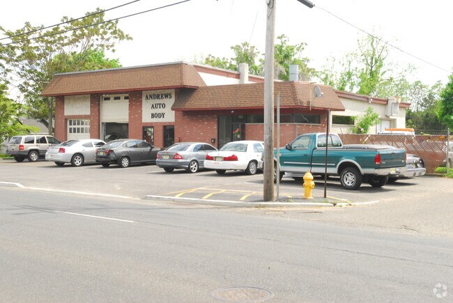
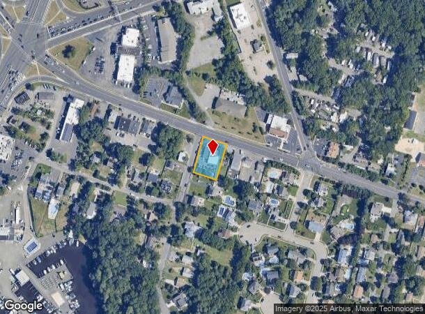
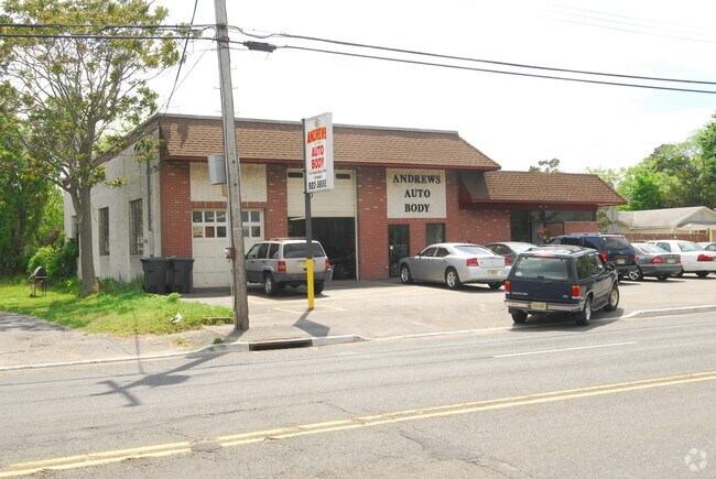
Property Record
27 Princeton Ave, Brick, NJ 08724

NEARBY LISTINGS FOR SALE OR LEASE
Property Detail
27 Princeton Ave
07-00857-0000-00005
.34AC 6
Commercialnec
Ocean
X
New Jersey
34025C0435F
5
2024
0.34 AC
2025
Ocean County
713500
Northern New Jersey
3,565 SF
New York-Jersey City-White Plains, NY-NJ
DEMOGRAPHICS near 27 Princeton Ave
1 Mile
3 Mile
5 Mile
2024 Total Population
7,027
79,905
204,952
2029 Population
7,423
84,414
215,176
Pop Growth 2024-2029
+ 5.64%
+ 5.64%
+ 4.99%
Average Age
44
41
38
2024 Total Households
2,897
30,554
69,757
HH Growth 2024-2029
+ 4.94%
+ 5.04%
+ 4.76%
Median Household Inc
$72,522
$84,501
$83,019
Avg Household Size
2.20
2.50
2.70
2024 Avg HH Vehicles
2.00
2.00
2.00
Median Home Value
$344,990
$338,760
$368,516
Median Year Built
1978
1974
1978
Nearby Places
Map Layers
Map Styles
 Street
 Aerial
- Restaurants
- Banks
- Shops
- Fitness
- Groceries
PUBLIC TRANSPORTATION
COMMUTER RAIL
Bay Head (North Jersey Coast Line - NJ Transit Commuter Rail (NJ Transit))
DRIVE
WALK
Distance
Bay Head (North Jersey Coast Line - NJ Transit Commuter Rail (NJ Transit))
10 min
5.1 mi
Manasquan (North Jersey Coast Line - NJ Transit Commuter Rail (NJ Transit))
DRIVE
WALK
Distance
Manasquan (North Jersey Coast Line - NJ Transit Commuter Rail (NJ Transit))
10 min
6.9 mi
Freight Ports
New York Container Terminal
DRIVE
WALK
Distance
New York Container Terminal
68 min
51.2 mi
Nearby Properties
Address
Land Use
TOTAL SIZE
Lot Size
Zoning
Address
Land Use
TOTAL SIZE
Lot Size
Zoning
45.53 AC
B3
Address
Land Use
TOTAL SIZE
Lot Size
Zoning
22.88 AC
HS
Address
Land Use
TOTAL SIZE
Lot Size
Zoning
29.34 AC
B4
Address
Land Use
TOTAL SIZE
Lot Size
Zoning
23,843 SF
37.83 AC
B5
Address
Land Use
TOTAL SIZE
Lot Size
Zoning
272,500 SF
17.88 AC
M1
Address
Land Use
TOTAL SIZE
Lot Size
Zoning
25.22 AC
B3
Address
Land Use
TOTAL SIZE
Lot Size
Zoning
49.57 AC
RR1
Address
Land Use
TOTAL SIZE
Lot Size
Zoning
1.80 AC
B5
Address
Land Use
TOTAL SIZE
Lot Size
Zoning
22.34 AC
ABC
Address
Land Use
TOTAL SIZE
Lot Size
Zoning
26.37 AC
R75
Address
Land Use
TOTAL SIZE
Lot Size
Zoning
5,826 SF
15.35 AC
RM
Address
Land Use
TOTAL SIZE
Lot Size
Zoning
30 AC
RR1
Address
Land Use
TOTAL SIZE
Lot Size
Zoning
39.84 AC
OPT
Address
Land Use
TOTAL SIZE
Lot Size
Zoning
39,777 SF
3.50 AC
M1
Address
Land Use
TOTAL SIZE
Lot Size
Zoning
26.43 AC
B3
Address
Land Use
TOTAL SIZE
Lot Size
Zoning
5,290 SF
12.95 AC
LP
Address
Land Use
TOTAL SIZE
Lot Size
Zoning
38,920 SF
9.70 AC
M1
Address
Land Use
TOTAL SIZE
Lot Size
Zoning
152.17 AC
ABC
Address
Land Use
TOTAL SIZE
Lot Size
Zoning
15.31 AC
B3
Address
Land Use
TOTAL SIZE
Lot Size
Zoning
11.83 AC
B3
Address
Land Use
TOTAL SIZE
Lot Size
Zoning
274,160 SF
42.09 AC
ABC
Address
Land Use
TOTAL SIZE
Lot Size
Zoning
9,429 SF
9.12 AC
B3
Address
Land Use
TOTAL SIZE
Lot Size
Zoning
47.75 AC
RR2
Address
Land Use
TOTAL SIZE
Lot Size
Zoning
14.38 AC
B3
Address
Land Use
TOTAL SIZE
Lot Size
Zoning
75,308 SF
3 AC
M1
Address
Land Use
TOTAL SIZE
Lot Size
Zoning
32.50 AC
RM
Address
Land Use
TOTAL SIZE
Lot Size
Zoning
32.80 AC
RM
Address
Land Use
TOTAL SIZE
Lot Size
Zoning
13.82 AC
RM
Address
Land Use
TOTAL SIZE
Lot Size
Zoning
18.39 AC
B3
Address
Land Use
TOTAL SIZE
Lot Size
Zoning
194,670 SF
22 AC
M1
The World's #1 Commercial Real Estate Marketplace
Connect with us
© 2025 CoStar Group
The information above has been obtained from sources believed reliable. While we do not doubt its accuracy we have not verified it and make no guarantee, warranty or representation about it. It is your responsibility to independently confirm its accuracy and completeness. Any projections, opinions, assumptions, or estimates used are for example only and do not represent the current or future performance of the property. The value of this transaction to you depends on tax and other factors which should be evaluated by your tax, financial, and legal advisors. You and your advisors should conduct a careful, independent investigation of the property to determine to your satisfaction the suitability of the property for your needs.