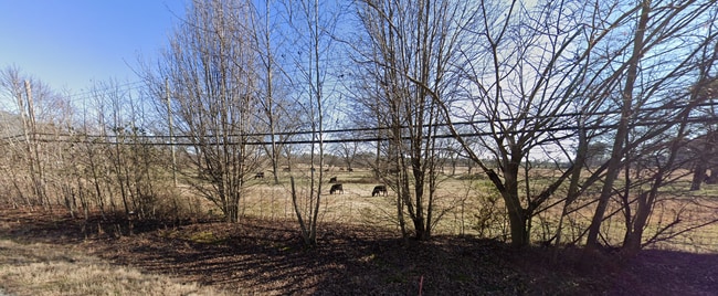
Property Record
27 Rex Rd, Williamson, GA 30292

NEARBY LISTINGS FOR SALE OR LEASE
-
-
No Photo
-
-
-
View all Williamson listings for sale on LoopNet.com
Property Detail
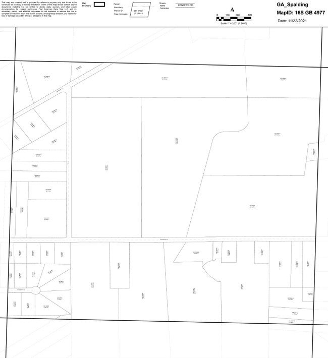
27 Rex Rd
234-05-001
87.91 AC REX RD PB 25/448
Ruralagriculturalresidence
Spalding
X
Georgia
13255C0180D
87.91 AC
2025
Spalding County
2025
Atlanta
161201
Atlanta-Sandy Springs-Roswell, GA
2,306 SF
DEMOGRAPHICS near 27 Rex Rd
1 Mile
3 Mile
5 Mile
2024 Total Population
722
11,794
40,421
2029 Population
810
13,388
46,369
Pop Growth 2024-2029
+ 12.19%
+ 13.52%
+ 14.72%
Average Age
39
39
39
2024 Total Households
255
4,280
15,195
HH Growth 2024-2029
+ 12.55%
+ 13.43%
+ 14.64%
Median Household Inc
$57,333
$59,716
$55,337
Avg Household Size
2.80
2.60
2.60
2024 Avg HH Vehicles
2.00
2.00
2.00
Median Home Value
$163,483
$182,568
$188,311
Median Year Built
1995
1990
1982
Nearby Places
Map Layers
Map Styles
 Street
 Aerial
- Restaurants
- Banks
- Shops
- Fitness
- Groceries
Nearby Properties
Address
Land Use
TOTAL SIZE
Lot Size
Zoning
Address
Land Use
TOTAL SIZE
Lot Size
Zoning
112,554 SF
40.27 AC
C2
Address
Land Use
TOTAL SIZE
Lot Size
Zoning
46,074 SF
30.36 AC
OI
Address
Land Use
TOTAL SIZE
Lot Size
Zoning
31,328 SF
58.43 AC
PID
Address
Land Use
TOTAL SIZE
Lot Size
Zoning
31,328 SF
58.43 AC
PID
Address
Land Use
TOTAL SIZE
Lot Size
Zoning
89.45 AC
INST
Address
Land Use
TOTAL SIZE
Lot Size
Zoning
99,469 SF
12.51 AC
AR-1
Address
Land Use
TOTAL SIZE
Lot Size
Zoning
2,374 SF
38.28 AC
HDRB
Address
Land Use
TOTAL SIZE
Lot Size
Zoning
3,069 SF
15 AC
HDR-B
Address
Land Use
TOTAL SIZE
Lot Size
Zoning
3,716 SF
12.03 AC
PRD
Address
Land Use
TOTAL SIZE
Lot Size
Zoning
74,910 SF
25 AC
AR-1
Address
Land Use
TOTAL SIZE
Lot Size
Zoning
840 SF
11.74 AC
HDR-B
Address
Land Use
TOTAL SIZE
Lot Size
Zoning
57,929 SF
11.90 AC
Address
Land Use
TOTAL SIZE
Lot Size
Zoning
43,440 SF
23.20 AC
AR-1
Address
Land Use
TOTAL SIZE
Lot Size
Zoning
41,194 SF
25.19 AC
C-1
Address
Land Use
TOTAL SIZE
Lot Size
Zoning
39,777 SF
10.23 AC
INST
Address
Land Use
TOTAL SIZE
Lot Size
Zoning
56,516 SF
28.30 AC
C1
Address
Land Use
TOTAL SIZE
Lot Size
Zoning
5,640 SF
86.60 AC
C2
Address
Land Use
TOTAL SIZE
Lot Size
Zoning
16,519 SF
6.02 AC
Address
Land Use
TOTAL SIZE
Lot Size
Zoning
99,088 SF
25.64 AC
PID
Address
Land Use
TOTAL SIZE
Lot Size
Zoning
22,158 SF
3.52 AC
C2
Address
Land Use
TOTAL SIZE
Lot Size
Zoning
91,826 SF
18.21 AC
PID
Address
Land Use
TOTAL SIZE
Lot Size
Zoning
36,751 SF
101.99 AC
Address
Land Use
TOTAL SIZE
Lot Size
Zoning
62,250 SF
10.17 AC
Address
Land Use
TOTAL SIZE
Lot Size
Zoning
2,400 SF
5.18 AC
C-1B
Address
Land Use
TOTAL SIZE
Lot Size
Zoning
14,732 SF
1.74 AC
C1
Address
Land Use
TOTAL SIZE
Lot Size
Zoning
483.12 AC
RESIDENTIA
Address
Land Use
TOTAL SIZE
Lot Size
Zoning
19,600 SF
5.03 AC
PID
Address
Land Use
TOTAL SIZE
Lot Size
Zoning
5,544 SF
8.49 AC
C1
Address
Land Use
TOTAL SIZE
Lot Size
Zoning
22,530 SF
5 AC
PID
Address
Land Use
TOTAL SIZE
Lot Size
Zoning
6,732 SF
6.71 AC
The World's #1 Commercial Real Estate Marketplace
Connect with us
© 2026 CoStar Group
The information above has been obtained from sources believed reliable. While we do not doubt its accuracy we have not verified it and make no guarantee, warranty or representation about it. It is your responsibility to independently confirm its accuracy and completeness. Any projections, opinions, assumptions, or estimates used are for example only and do not represent the current or future performance of the property. The value of this transaction to you depends on tax and other factors which should be evaluated by your tax, financial, and legal advisors. You and your advisors should conduct a careful, independent investigation of the property to determine to your satisfaction the suitability of the property for your needs.