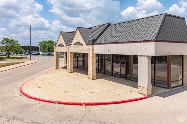
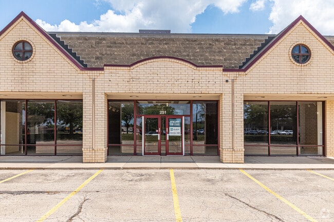
Property Record
27 S Rt 59, Aurora, IL 60504

Property Detail
27 S Rt 59
07-28-201-017
RAY W MC DONALD CO CLK HARRISON-CARTER ASSMT PLAT AMENDED PRT LYG E OF FOX VALLEY VILLAGES UNIT NO 27 /EX APPLE SOUTH ASSMT PLAT/ & /EX HWY DESC 95ED10/
Commercialnec
DUPAGE
C
Illinois
B and X Area of moderate flood hazard, usually the area between the limits of the 100-year and 500-year floods.
1
2024
31.05 AC
2024
Western East/West Corr
846515
Chicago
342,257 SF
Chicago-Naperville-Elgin, IL-IN
NEARBY LISTINGS FOR SALE OR LEASE
DEMOGRAPHICS near 27 S Rt 59
1 mile
3 mile
5 mile
2025 Total Population
11,448
99,100
264,323
2030 Population
11,758
100,576
268,283
Pop Growth 2025-2030
+ 2.71%
+ 1.49%
+ 1.50%
Average Age
36
38
39
2025 Total Households
4,382
36,645
92,348
HH Growth 2025-2030
+ 2.60%
+ 1.52%
+ 1.61%
Median Household Inc
$108,915
$118,731
$122,278
Avg Household Size
2.60
2.60
2.80
2025 Avg HH Vehicles
2.00
2.00
2.00
Median Home Value
$354,900
$403,752
$419,274
Median Year Built
1995
1993
1990
Nearby Places
Map Layers
Map Styles
 Street
 Aerial
Transit
 Traffic
 Biking
Places
Listings with unknown addresses are not visible on the map
- Restaurants
- Banks
- Shops
- Fitness
- Groceries
PUBLIC TRANSPORTATION
COMMUTER RAIL
Route 59 Station (Burlington Northern-Santa Fe Railway Line - Northeast Illinois Regional Commuter Railroad (Metra))
Drive
Walk
Distance
Route 59 Station (Burlington Northern-Santa Fe Railway Line - Northeast Illinois Regional Commuter Railroad (Metra))
7 min
2.9 mi
Naperville Station (Burlington Northern-Santa Fe Railway Line - Northeast Illinois Regional Commuter Railroad (Metra))
Drive
Walk
Distance
Naperville Station (Burlington Northern-Santa Fe Railway Line - Northeast Illinois Regional Commuter Railroad (Metra))
12 min
5.4 mi
AIRPORT
Chicago Midway International
Drive
Walk
Distance
Chicago Midway International
43 min
26.3 mi
Chicago O'Hare International
Drive
Walk
Distance
Chicago O'Hare International
49 min
33.0 mi
Freight Ports
Port Milwaukee
Drive
Walk
Distance
Port Milwaukee
130 min
104.7 mi
SALE & LEASE HISTORY
LISTING DATE
SALE/LEASE

Sep 25, 2016
For Lease
Nearby Properties
Address
Land Use
TOTAL SIZE
Lot Size
Zoning
Address
Land Use
TOTAL SIZE
Lot Size
Zoning
916,143 SF
32.66 AC
Address
Land Use
TOTAL SIZE
Lot Size
Zoning
28.52 AC
R
Address
Land Use
TOTAL SIZE
Lot Size
Zoning
29.20 AC
C
Address
Land Use
TOTAL SIZE
Lot Size
Zoning
20.60 AC
Address
Land Use
TOTAL SIZE
Lot Size
Zoning
19.92 AC
C
Address
Land Use
TOTAL SIZE
Lot Size
Zoning
17.70 AC
Address
Land Use
TOTAL SIZE
Lot Size
Zoning
Address
Land Use
TOTAL SIZE
Lot Size
Zoning
Address
Land Use
TOTAL SIZE
Lot Size
Zoning
829,087 SF
35.83 AC
C
Address
Land Use
TOTAL SIZE
Lot Size
Zoning
22.35 AC
Address
Land Use
TOTAL SIZE
Lot Size
Zoning
25 AC
M
Address
Land Use
TOTAL SIZE
Lot Size
Zoning
283,844 SF
16.06 AC
M
Address
Land Use
TOTAL SIZE
Lot Size
Zoning
20.97 AC
R
Address
Land Use
TOTAL SIZE
Lot Size
Zoning
24.91 AC
Address
Land Use
TOTAL SIZE
Lot Size
Zoning
17.84 AC
M
Address
Land Use
TOTAL SIZE
Lot Size
Zoning
16.15 AC
M
Address
Land Use
TOTAL SIZE
Lot Size
Zoning
15.61 AC
M
Address
Land Use
TOTAL SIZE
Lot Size
Zoning
16.86 AC
C
Address
Land Use
TOTAL SIZE
Lot Size
Zoning
12.70 AC
Address
Land Use
TOTAL SIZE
Lot Size
Zoning
11.02 AC
M
Address
Land Use
TOTAL SIZE
Lot Size
Zoning
9.83 AC
C
Address
Land Use
TOTAL SIZE
Lot Size
Zoning
293,121 SF
9.50 AC
Address
Land Use
TOTAL SIZE
Lot Size
Zoning
594,880 SF
29.15 AC
I
Address
Land Use
TOTAL SIZE
Lot Size
Zoning
173,303 SF
19.53 AC
Address
Land Use
TOTAL SIZE
Lot Size
Zoning
10 AC
C
Address
Land Use
TOTAL SIZE
Lot Size
Zoning
133,779 SF
9.77 AC
C
Address
Land Use
TOTAL SIZE
Lot Size
Zoning
184,882 SF
7.25 AC
C
Address
Land Use
TOTAL SIZE
Lot Size
Zoning
363,500 SF
19.89 AC
Address
Land Use
TOTAL SIZE
Lot Size
Zoning
367,519 SF
15.98 AC
The World's #1 Commercial Real Estate Marketplace
Connect with us
© 2026 CoStar Group
The information above has been obtained from sources believed reliable. While we do not doubt its accuracy we have not verified it and make no guarantee, warranty or representation about it. It is your responsibility to independently confirm its accuracy and completeness. Any projections, opinions, assumptions, or estimates used are for example only and do not represent the current or future performance of the property. The value of this transaction to you depends on tax and other factors which should be evaluated by your tax, financial, and legal advisors. You and your advisors should conduct a careful, independent investigation of the property to determine to your satisfaction the suitability of the property for your needs.