Property Record
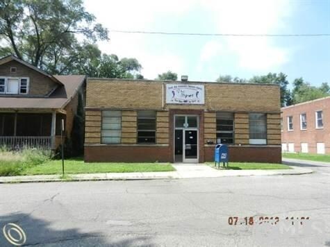
27 Salliotte Rd, Ecorse, MI 48229


NEARBY LISTINGS FOR SALE OR LEASE
Property Detail
27 Salliotte Rd
Detroit-Warren-Dearborn, MI
Lafferty And Heide
34-006-06-0055-000
496D55 LOT 55 ALSO THE ADJ VAC ELY 1/2 OF LAFFERTY STREET LAFFERTY AND HEIDE SUB PC 496 L29 P62 WCR
Officebuilding
Wayne
X
Michigan
26163C0269F
55
2024
0.07 AC
2025
Downriver North
579501
Detroit
3,619 SF
DEMOGRAPHICS near 27 Salliotte Rd
1 Mile
3 Mile
5 Mile
2024 Total Population
11,948
75,895
185,457
2029 Population
11,796
73,576
178,827
Pop Growth 2024-2029
(1.27%)
(3.06%)
(3.57%)
Average Age
38
39
39
2024 Total Households
4,576
29,846
72,745
HH Growth 2024-2029
(1.35%)
(3.14%)
(3.62%)
Median Household Inc
$41,662
$46,932
$53,491
Avg Household Size
2.60
2.50
2.50
2024 Avg HH Vehicles
1.00
2.00
2.00
Median Home Value
$59,462
$104,476
$133,432
Median Year Built
1952
1952
1953
Nearby Places
Map Layers
Map Styles
 Street
 Aerial
- Restaurants
- Banks
- Shops
- Fitness
- Groceries
PUBLIC TRANSPORTATION
COMMUTER RAIL
Dearborn (Wolverine - Amtrak)
DRIVE
WALK
Distance
Dearborn (Wolverine - Amtrak)
18 min
8.0 mi
AIRPORT
Detroit Metro Wayne County
DRIVE
WALK
Distance
Detroit Metro Wayne County
26 min
16.1 mi
Windsor International
DRIVE
WALK
Distance
Windsor International
37 min
19.5 mi
Freight Ports
Port of Toledo
DRIVE
WALK
Distance
Port of Toledo
68 min
54.0 mi
Nearby Properties
Address
Land Use
TOTAL SIZE
Lot Size
Zoning
Address
Land Use
TOTAL SIZE
Lot Size
Zoning
1,025,154 SF
233.15 AC
Address
Land Use
TOTAL SIZE
Lot Size
Zoning
7,320 SF
226.49 AC
Address
Land Use
TOTAL SIZE
Lot Size
Zoning
187,395 SF
Address
Land Use
TOTAL SIZE
Lot Size
Zoning
114,157 SF
Address
Land Use
TOTAL SIZE
Lot Size
Zoning
196,801 SF
38.32 AC
M5
Address
Land Use
TOTAL SIZE
Lot Size
Zoning
145,572 SF
58.41 AC
M4
Address
Land Use
TOTAL SIZE
Lot Size
Zoning
76,350 SF
0.69 AC
Address
Land Use
TOTAL SIZE
Lot Size
Zoning
79.03 AC
M2 HEAV
Address
Land Use
TOTAL SIZE
Lot Size
Zoning
351,906 SF
42.21 AC
M4
Address
Land Use
TOTAL SIZE
Lot Size
Zoning
660 SF
41.97 AC
R1 1 FA
Address
Land Use
TOTAL SIZE
Lot Size
Zoning
105,920 SF
12.46 AC
Address
Land Use
TOTAL SIZE
Lot Size
Zoning
45,400 SF
R1 1 FA
Address
Land Use
TOTAL SIZE
Lot Size
Zoning
32,245 SF
23.27 AC
M5
Address
Land Use
TOTAL SIZE
Lot Size
Zoning
105,503 SF
19.83 AC
Address
Land Use
TOTAL SIZE
Lot Size
Zoning
121,912 SF
7.88 AC
Address
Land Use
TOTAL SIZE
Lot Size
Zoning
77,026 SF
9.64 AC
R1 1 FA
Address
Land Use
TOTAL SIZE
Lot Size
Zoning
106.97 AC
M2 HEAV
Address
Land Use
TOTAL SIZE
Lot Size
Zoning
228,000 SF
12.70 AC
Address
Land Use
TOTAL SIZE
Lot Size
Zoning
414,868 SF
26.36 AC
R1 1 FA
Address
Land Use
TOTAL SIZE
Lot Size
Zoning
8,774 SF
29.39 AC
R1 1 FA
Address
Land Use
TOTAL SIZE
Lot Size
Zoning
78,580 SF
0.62 AC
Address
Land Use
TOTAL SIZE
Lot Size
Zoning
2,220 SF
10.66 AC
Address
Land Use
TOTAL SIZE
Lot Size
Zoning
108,000 SF
7.46 AC
Address
Land Use
TOTAL SIZE
Lot Size
Zoning
292,797 SF
9.31 AC
Address
Land Use
TOTAL SIZE
Lot Size
Zoning
182,640 SF
13.98 AC
Address
Land Use
TOTAL SIZE
Lot Size
Zoning
282,489 SF
15.96 AC
Address
Land Use
TOTAL SIZE
Lot Size
Zoning
19,361 SF
2.09 AC
Address
Land Use
TOTAL SIZE
Lot Size
Zoning
178,795 SF
5.66 AC
R1 1 FA
Address
Land Use
TOTAL SIZE
Lot Size
Zoning
126,078 SF
6.62 AC
R1 1 FA
Address
Land Use
TOTAL SIZE
Lot Size
Zoning
128,608 SF
0.93 AC
The World's #1 Commercial Real Estate Marketplace
Connect with us
© 2025 CoStar Group
The information above has been obtained from sources believed reliable. While we do not doubt its accuracy we have not verified it and make no guarantee, warranty or representation about it. It is your responsibility to independently confirm its accuracy and completeness. Any projections, opinions, assumptions, or estimates used are for example only and do not represent the current or future performance of the property. The value of this transaction to you depends on tax and other factors which should be evaluated by your tax, financial, and legal advisors. You and your advisors should conduct a careful, independent investigation of the property to determine to your satisfaction the suitability of the property for your needs.