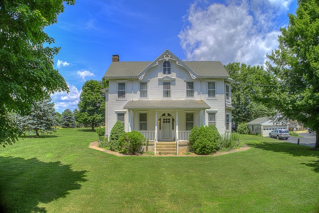
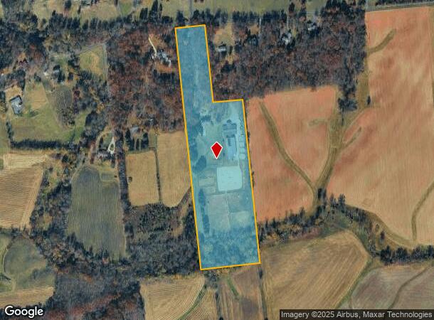
Property Record
27 Yard Rd, Stockton, NJ 08559
NEARBY LISTINGS FOR SALE OR LEASE
-
-
View all Stockton listings for sale on LoopNet.com
Property Detail
27 Yard Rd
07-00044-0000-00004-05-Q0826
Hunterdon
Farms
New Jersey
AE
4.5
34019C0334F
18.58 AC
2024
Hunterdon
2025
Northern New Jersey
011600
Newark, NJ-PA
DEMOGRAPHICS near 27 Yard Rd
1 Mile
3 Mile
5 Mile
2024 Total Population
222
7,135
29,518
2029 Population
222
7,189
29,924
Pop Growth 2024-2029
0.00%
+ 0.76%
+ 1.38%
Average Age
47
44
43
2024 Total Households
85
2,499
11,280
HH Growth 2024-2029
0.00%
+ 0.68%
+ 1.35%
Median Household Inc
$145,833
$152,105
$115,441
Avg Household Size
2.60
2.80
2.60
2024 Avg HH Vehicles
2.00
2.00
2.00
Median Home Value
$668,478
$641,906
$462,373
Median Year Built
1979
1983
1982
Nearby Places
Map Layers
Map Styles
 Street
 Aerial
- Restaurants
- Banks
- Shops
- Fitness
- Groceries
PUBLIC TRANSPORTATION
AIRPORT
Trenton Mercer
DRIVE
WALK
Distance
Trenton Mercer
34 min
17.1 mi
Freight Ports
Port of Philadelphia
DRIVE
WALK
Distance
Port of Philadelphia
71 min
39.5 mi
SALE & LEASE HISTORY
LISTING DATE
SALE/LEASE

Jul 10, 2018
For Sale
Nearby Properties
Address
Land Use
TOTAL SIZE
Lot Size
Zoning
Address
Land Use
TOTAL SIZE
Lot Size
Zoning
65.10 AC
I-1
Address
Land Use
TOTAL SIZE
Lot Size
Zoning
Address
Land Use
TOTAL SIZE
Lot Size
Zoning
40 AC
AR-2
Address
Land Use
TOTAL SIZE
Lot Size
Zoning
Address
Land Use
TOTAL SIZE
Lot Size
Zoning
5.47 AC
B-2
Address
Land Use
TOTAL SIZE
Lot Size
Zoning
6.16 AC
B-2
Address
Land Use
TOTAL SIZE
Lot Size
Zoning
9.94 AC
B-2
Address
Land Use
TOTAL SIZE
Lot Size
Zoning
2.64 AC
B-2
Address
Land Use
TOTAL SIZE
Lot Size
Zoning
31.35 AC
VAL
Address
Land Use
TOTAL SIZE
Lot Size
Zoning
6.57 AC
B-2
Address
Land Use
TOTAL SIZE
Lot Size
Zoning
10.40 AC
B-2
Address
Land Use
TOTAL SIZE
Lot Size
Zoning
Address
Land Use
TOTAL SIZE
Lot Size
Zoning
11,756 SF
25.62 AC
A-1
Address
Land Use
TOTAL SIZE
Lot Size
Zoning
3.18 AC
B-2
Address
Land Use
TOTAL SIZE
Lot Size
Zoning
10.26 AC
B-2
Address
Land Use
TOTAL SIZE
Lot Size
Zoning
1,516 SF
5.09 AC
B-2
Address
Land Use
TOTAL SIZE
Lot Size
Zoning
1,560 SF
136.68 AC
AR-2
Address
Land Use
TOTAL SIZE
Lot Size
Zoning
11 AC
VAL
Address
Land Use
TOTAL SIZE
Lot Size
Zoning
3.55 AC
B-2
Address
Land Use
TOTAL SIZE
Lot Size
Zoning
77.26 AC
AR-5
Address
Land Use
TOTAL SIZE
Lot Size
Zoning
148.35 AC
AR-5
Address
Land Use
TOTAL SIZE
Lot Size
Zoning
7.98 AC
B-5
Address
Land Use
TOTAL SIZE
Lot Size
Zoning
Address
Land Use
TOTAL SIZE
Lot Size
Zoning
72.39 AC
AR-2
Address
Land Use
TOTAL SIZE
Lot Size
Zoning
3.25 AC
B-5
Address
Land Use
TOTAL SIZE
Lot Size
Zoning
10,084 SF
2 AC
VAL
Address
Land Use
TOTAL SIZE
Lot Size
Zoning
31.50 AC
AR-2
Address
Land Use
TOTAL SIZE
Lot Size
Zoning
1,280 SF
12 AC
AR-2
Address
Land Use
TOTAL SIZE
Lot Size
Zoning
10 AC
HO
Address
Land Use
TOTAL SIZE
Lot Size
Zoning
1,088 SF
3.59 AC
B-5
The World's #1 Commercial Real Estate Marketplace
Connect with us
© 2025 CoStar Group
The information above has been obtained from sources believed reliable. While we do not doubt its accuracy we have not verified it and make no guarantee, warranty or representation about it. It is your responsibility to independently confirm its accuracy and completeness. Any projections, opinions, assumptions, or estimates used are for example only and do not represent the current or future performance of the property. The value of this transaction to you depends on tax and other factors which should be evaluated by your tax, financial, and legal advisors. You and your advisors should conduct a careful, independent investigation of the property to determine to your satisfaction the suitability of the property for your needs.