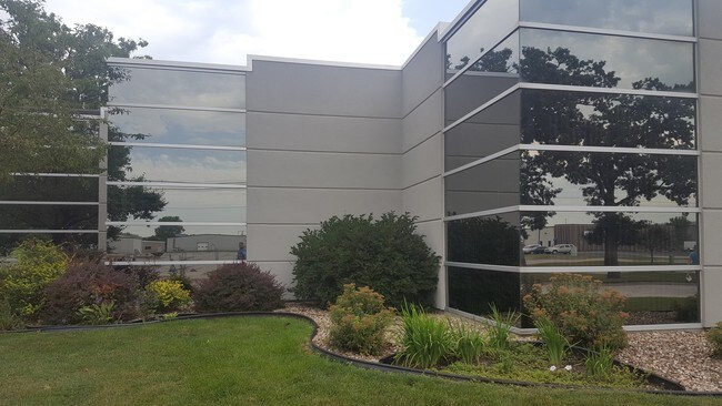
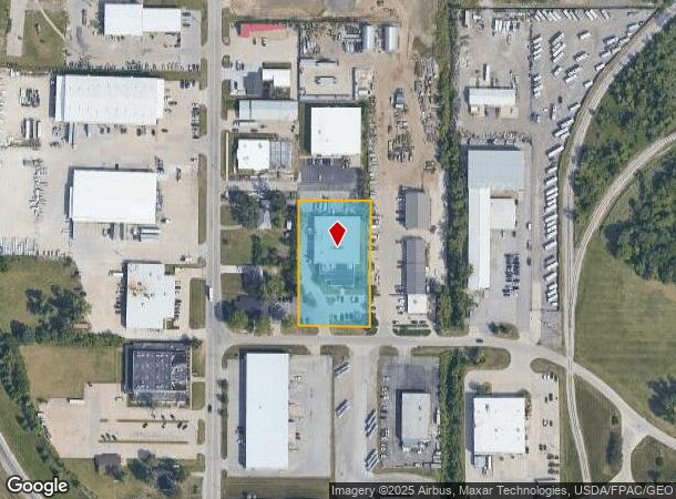
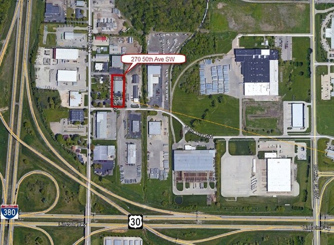
Property Record
270 50Th Ave Sw, Cedar Rapids, IA 52404
NEARBY LISTINGS FOR SALE OR LEASE
-
-
-
8205 6th Street Southwest-Building 2
Cedar Rapids, IA 52404
$9.25 SF/YR
7,500 - 61,000 SF
Industrial
-
-
View all Cedar Rapids listings for lease on LoopNet.com
Property Detail
270 50Th Ave Sw
19091-26020-00000
Point 1St
Warehouse
POINT 1ST STR/LB 2
X
Linn
19113C0420E
Iowa
2024
2
2025
1.82 AC
003004
Other Market Areas
19,170 SF
Cedar Rapids, IA
DEMOGRAPHICS near 270 50Th Ave Sw
1 Mile
3 Mile
5 Mile
2024 Total Population
3,741
30,311
90,476
2029 Population
3,767
30,379
90,393
Pop Growth 2024-2029
+ 0.70%
+ 0.22%
(0.09%)
Average Age
33
37
39
2024 Total Households
1,549
12,490
38,008
HH Growth 2024-2029
+ 0.71%
+ 0.26%
(0.07%)
Median Household Inc
$34,591
$58,902
$58,133
Avg Household Size
2.20
2.30
2.20
2024 Avg HH Vehicles
2.00
2.00
2.00
Median Home Value
$103,777
$161,371
$161,134
Median Year Built
1983
1975
1969
Nearby Places
Map Layers
Map Styles
 Street
 Aerial
- Restaurants
- Banks
- Shops
- Fitness
- Groceries
PUBLIC TRANSPORTATION
AIRPORT
The Eastern Iowa
DRIVE
WALK
Distance
The Eastern Iowa
14 min
7.5 mi
Freight Ports
Port Milwaukee
DRIVE
WALK
Distance
Port Milwaukee
299 min
251.4 mi
SALE & LEASE HISTORY
LISTING DATE
SALE/LEASE

Jun 18, 2018
For Lease
Nearby Properties
Address
Land Use
TOTAL SIZE
Lot Size
Zoning
Address
Land Use
TOTAL SIZE
Lot Size
Zoning
269,397 SF
153.19 AC
Address
Land Use
TOTAL SIZE
Lot Size
Zoning
1,012,084 SF
45.85 AC
Address
Land Use
TOTAL SIZE
Lot Size
Zoning
647,731 SF
127.92 AC
Address
Land Use
TOTAL SIZE
Lot Size
Zoning
103,804 SF
46.29 AC
Address
Land Use
TOTAL SIZE
Lot Size
Zoning
231,824 SF
31.61 AC
Address
Land Use
TOTAL SIZE
Lot Size
Zoning
308,309 SF
17.97 AC
Address
Land Use
TOTAL SIZE
Lot Size
Zoning
550,428 SF
78.91 AC
Address
Land Use
TOTAL SIZE
Lot Size
Zoning
142,137 SF
34.61 AC
Address
Land Use
TOTAL SIZE
Lot Size
Zoning
592,459 SF
45.65 AC
Address
Land Use
TOTAL SIZE
Lot Size
Zoning
172,000 SF
168.92 AC
Address
Land Use
TOTAL SIZE
Lot Size
Zoning
218,451 SF
18.74 AC
Address
Land Use
TOTAL SIZE
Lot Size
Zoning
1,049,268 SF
79.35 AC
Address
Land Use
TOTAL SIZE
Lot Size
Zoning
220,128 SF
71.19 AC
Address
Land Use
TOTAL SIZE
Lot Size
Zoning
23,585 SF
1.05 AC
Address
Land Use
TOTAL SIZE
Lot Size
Zoning
243,300 SF
22.44 AC
Address
Land Use
TOTAL SIZE
Lot Size
Zoning
339,558 SF
38.50 AC
Address
Land Use
TOTAL SIZE
Lot Size
Zoning
80,530 SF
2.96 AC
Address
Land Use
TOTAL SIZE
Lot Size
Zoning
156,678 SF
21.85 AC
Address
Land Use
TOTAL SIZE
Lot Size
Zoning
907,717 SF
152.19 AC
Address
Land Use
TOTAL SIZE
Lot Size
Zoning
224,710 SF
22.66 AC
Address
Land Use
TOTAL SIZE
Lot Size
Zoning
56,178 SF
0.97 AC
Address
Land Use
TOTAL SIZE
Lot Size
Zoning
56,924 SF
Address
Land Use
TOTAL SIZE
Lot Size
Zoning
315,459 SF
13.85 AC
Address
Land Use
TOTAL SIZE
Lot Size
Zoning
157,850 SF
17.53 AC
Address
Land Use
TOTAL SIZE
Lot Size
Zoning
203,840 SF
18.22 AC
Address
Land Use
TOTAL SIZE
Lot Size
Zoning
212,316 SF
23.89 AC
Address
Land Use
TOTAL SIZE
Lot Size
Zoning
205,013 SF
16.44 AC
Address
Land Use
TOTAL SIZE
Lot Size
Zoning
410,000 SF
21.20 AC
Address
Land Use
TOTAL SIZE
Lot Size
Zoning
198,251 SF
16.85 AC
Address
Land Use
TOTAL SIZE
Lot Size
Zoning
175,600 SF
15.91 AC
The World's #1 Commercial Real Estate Marketplace
Connect with us
© 2025 CoStar Group
The information above has been obtained from sources believed reliable. While we do not doubt its accuracy we have not verified it and make no guarantee, warranty or representation about it. It is your responsibility to independently confirm its accuracy and completeness. Any projections, opinions, assumptions, or estimates used are for example only and do not represent the current or future performance of the property. The value of this transaction to you depends on tax and other factors which should be evaluated by your tax, financial, and legal advisors. You and your advisors should conduct a careful, independent investigation of the property to determine to your satisfaction the suitability of the property for your needs.