Property Record
270 Coleman Blvd, Mount Pleasant, SC 29464
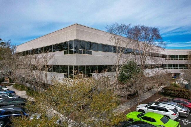


Property Detail
270 Coleman Blvd
415-00-00-029
SUBDIVISION NAME -PART ORANGE GROVE DESCRIPTION -TRACT A & B HIGH & PT WINDSOR RD SITE NAME -PARKSHORE CENTRE
Officebuilding
Charleston
C and X Area of minimal flood hazard, usually depicted on FIRMs as above the 500-year flood level.
South Carolina
2025
7.76 AC
2024
West Ashley
004622
Charleston/N Charleston
39,150 SF
Charleston-North Charleston, SC
NEARBY LISTINGS FOR SALE OR LEASE
DEMOGRAPHICS near 270 Coleman Blvd
1 mile
3 mile
5 mile
2025 Total Population
3,332
58,248
151,557
2030 Population
3,397
60,678
159,244
Pop Growth 2025-2030
+ 1.95%
+ 4.17%
+ 5.07%
Average Age
44
40
39
2025 Total Households
1,429
25,170
67,032
HH Growth 2025-2030
+ 1.96%
+ 4.16%
+ 5.21%
Median Household Inc
$104,707
$67,956
$76,194
Avg Household Size
2.30
2.10
2.10
2025 Avg HH Vehicles
2.00
1.00
2.00
Median Home Value
$490,725
$392,818
$458,382
Median Year Built
1968
1970
1976
Nearby Places
Map Layers
Map Styles
 Street
 Aerial
Layers
 Traffic
 Biking
Places
Listings with unknown addresses are not visible on the map
- Restaurants
- Banks
- Shops
- Fitness
- Groceries
PUBLIC TRANSPORTATION
COMMUTER RAIL
Drive
Walk
Distance
13 min
9.4 mi
AIRPORT
Charleston AFB/International
Drive
Walk
Distance
Charleston AFB/International
24 min
16.0 mi
Nearby Properties
Address
Land Use
TOTAL SIZE
Lot Size
Zoning
Address
Land Use
TOTAL SIZE
Lot Size
Zoning
247,883 SF
16.26 AC
Address
Land Use
TOTAL SIZE
Lot Size
Zoning
2,592 SF
13.64 AC
Address
Land Use
TOTAL SIZE
Lot Size
Zoning
Address
Land Use
TOTAL SIZE
Lot Size
Zoning
Address
Land Use
TOTAL SIZE
Lot Size
Zoning
85,408 SF
9.39 AC
Address
Land Use
TOTAL SIZE
Lot Size
Zoning
1,435 SF
1.98 AC
Address
Land Use
TOTAL SIZE
Lot Size
Zoning
6.11 AC
Address
Land Use
TOTAL SIZE
Lot Size
Zoning
Address
Land Use
TOTAL SIZE
Lot Size
Zoning
1,282 SF
8.42 AC
Address
Land Use
TOTAL SIZE
Lot Size
Zoning
5,733 SF
0.10 AC
Address
Land Use
TOTAL SIZE
Lot Size
Zoning
8,740 SF
0.58 AC
Address
Land Use
TOTAL SIZE
Lot Size
Zoning
1,150 SF
Address
Land Use
TOTAL SIZE
Lot Size
Zoning
24,320 SF
1.31 AC
Address
Land Use
TOTAL SIZE
Lot Size
Zoning
31,094 SF
5.97 AC
Address
Land Use
TOTAL SIZE
Lot Size
Zoning
12,358 SF
15.08 AC
Address
Land Use
TOTAL SIZE
Lot Size
Zoning
34,713 SF
13.51 AC
Address
Land Use
TOTAL SIZE
Lot Size
Zoning
119,711 SF
0.93 AC
Address
Land Use
TOTAL SIZE
Lot Size
Zoning
1.89 AC
Address
Land Use
TOTAL SIZE
Lot Size
Zoning
1,222 SF
13.62 AC
Address
Land Use
TOTAL SIZE
Lot Size
Zoning
2,960 SF
1.62 AC
Address
Land Use
TOTAL SIZE
Lot Size
Zoning
0.72 AC
Address
Land Use
TOTAL SIZE
Lot Size
Zoning
34,460 SF
1.77 AC
Address
Land Use
TOTAL SIZE
Lot Size
Zoning
1,872 SF
4.48 AC
Address
Land Use
TOTAL SIZE
Lot Size
Zoning
22,360 SF
1.06 AC
Address
Land Use
TOTAL SIZE
Lot Size
Zoning
14,576 SF
0.17 AC
Address
Land Use
TOTAL SIZE
Lot Size
Zoning
4,178 SF
0.22 AC
Address
Land Use
TOTAL SIZE
Lot Size
Zoning
7,499 SF
0.54 AC
Address
Land Use
TOTAL SIZE
Lot Size
Zoning
70,500 SF
2.51 AC
Address
Land Use
TOTAL SIZE
Lot Size
Zoning
1,615 SF
32.59 AC
The World's #1 Commercial Real Estate Marketplace
Connect with us
© 2026 CoStar Group
The information above has been obtained from sources believed reliable. While we do not doubt its accuracy we have not verified it and make no guarantee, warranty or representation about it. It is your responsibility to independently confirm its accuracy and completeness. Any projections, opinions, assumptions, or estimates used are for example only and do not represent the current or future performance of the property. The value of this transaction to you depends on tax and other factors which should be evaluated by your tax, financial, and legal advisors. You and your advisors should conduct a careful, independent investigation of the property to determine to your satisfaction the suitability of the property for your needs.