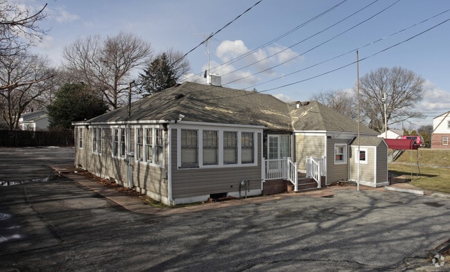
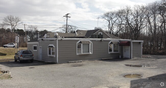
Property Record
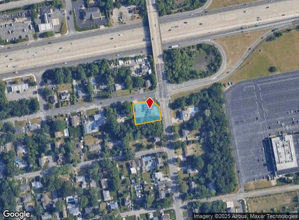
270 Connetquot Ave, East Islip, NY 11730
NEARBY LISTINGS FOR SALE OR LEASE
Property Detail
270 Connetquot Ave
Nassau County-Suffolk County, NY
X2229794Y190670 N063N00000000
0500-298-00-03-00-038-000
Suffolk
Restaurantbuilding
New York
X
300
36103C0881H
0.45 AC
0
Southwestern Suffolk
2024
Long Island (New York)
147505
DEMOGRAPHICS near 270 Connetquot Ave
1 Mile
3 Mile
5 Mile
2024 Total Population
8,139
64,364
184,992
2029 Population
7,989
63,148
180,783
Pop Growth 2024-2029
(1.84%)
(1.89%)
(2.28%)
Average Age
43
41
40
2024 Total Households
2,990
21,740
57,087
HH Growth 2024-2029
(2.07%)
(1.77%)
(2.19%)
Median Household Inc
$119,761
$116,388
$109,998
Avg Household Size
2.70
2.80
3.00
2024 Avg HH Vehicles
2.00
2.00
2.00
Median Home Value
$444,437
$457,834
$443,540
Median Year Built
1964
1967
1967
Nearby Places
- Restaurants
- Banks
- Shops
- Fitness
- Groceries
PUBLIC TRANSPORTATION
COMMUTER RAIL
Great River Station (Montauk Branch - Long Island Rail Road)
DRIVE
WALK
Distance
Great River Station (Montauk Branch - Long Island Rail Road)
2 min
9 min
0.5 mi
Oakdale Station (Montauk Branch - Long Island Rail Road)
DRIVE
WALK
Distance
Oakdale Station (Montauk Branch - Long Island Rail Road)
6 min
2.4 mi
AIRPORT
Long Island MacArthur
DRIVE
WALK
Distance
Long Island MacArthur
12 min
6.6 mi
John F Kennedy International
DRIVE
WALK
Distance
John F Kennedy International
52 min
36.4 mi
Freight Ports
NY - Red Hook Container Terminal
DRIVE
WALK
Distance
NY - Red Hook Container Terminal
72 min
48.0 mi
Nearby Properties
Address
Land Use
TOTAL SIZE
Lot Size
Zoning
Address
Land Use
TOTAL SIZE
Lot Size
Zoning
2,057.30 AC
AAA
Address
Land Use
TOTAL SIZE
Lot Size
Zoning
57.30 AC
IND1
Address
Land Use
TOTAL SIZE
Lot Size
Zoning
334.30 AC
AAA
Address
Land Use
TOTAL SIZE
Lot Size
Zoning
17.70 AC
A
Address
Land Use
TOTAL SIZE
Lot Size
Zoning
465.70 AC
AAA
Address
Land Use
TOTAL SIZE
Lot Size
Zoning
13 AC
OSC
Address
Land Use
TOTAL SIZE
Lot Size
Zoning
83.41 AC
Address
Land Use
TOTAL SIZE
Lot Size
Zoning
10,930 SF
175.30 AC
AAA
Address
Land Use
TOTAL SIZE
Lot Size
Zoning
27.38 AC
Address
Land Use
TOTAL SIZE
Lot Size
Zoning
33.30 AC
A
Address
Land Use
TOTAL SIZE
Lot Size
Zoning
360.60 AC
AAA
Address
Land Use
TOTAL SIZE
Lot Size
Zoning
216.20 AC
AAA
Address
Land Use
TOTAL SIZE
Lot Size
Zoning
339.70 AC
AAA
Address
Land Use
TOTAL SIZE
Lot Size
Zoning
41 AC
PDDGROI
Address
Land Use
TOTAL SIZE
Lot Size
Zoning
31.30 AC
IND1
Address
Land Use
TOTAL SIZE
Lot Size
Zoning
15.46 AC
PDDEC
Address
Land Use
TOTAL SIZE
Lot Size
Zoning
3.16 AC
A
Address
Land Use
TOTAL SIZE
Lot Size
Zoning
17.51 AC
Address
Land Use
TOTAL SIZE
Lot Size
Zoning
25 AC
AA
Address
Land Use
TOTAL SIZE
Lot Size
Zoning
19.86 AC
C
Address
Land Use
TOTAL SIZE
Lot Size
Zoning
10.90 AC
B
Address
Land Use
TOTAL SIZE
Lot Size
Zoning
Address
Land Use
TOTAL SIZE
Lot Size
Zoning
152.10 AC
AA
Address
Land Use
TOTAL SIZE
Lot Size
Zoning
19.04 AC
BUS1
Address
Land Use
TOTAL SIZE
Lot Size
Zoning
9.38 AC
B
Address
Land Use
TOTAL SIZE
Lot Size
Zoning
Address
Land Use
TOTAL SIZE
Lot Size
Zoning
11.05 AC
PDDOFF
Address
Land Use
TOTAL SIZE
Lot Size
Zoning
16 AC
PDDRI
Address
Land Use
TOTAL SIZE
Lot Size
Zoning
Address
Land Use
TOTAL SIZE
Lot Size
Zoning
7.70 AC
A
The World's #1 Commercial Real Estate Marketplace
Connect with us
© 2025 CoStar Group
The information above has been obtained from sources believed reliable. While we do not doubt its accuracy we have not verified it and make no guarantee, warranty or representation about it. It is your responsibility to independently confirm its accuracy and completeness. Any projections, opinions, assumptions, or estimates used are for example only and do not represent the current or future performance of the property. The value of this transaction to you depends on tax and other factors which should be evaluated by your tax, financial, and legal advisors. You and your advisors should conduct a careful, independent investigation of the property to determine to your satisfaction the suitability of the property for your needs.