Property Record
270 Cooley St, Springfield, MA 01128
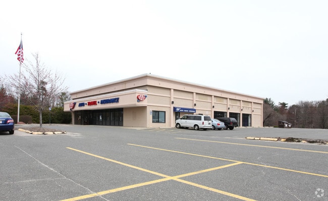

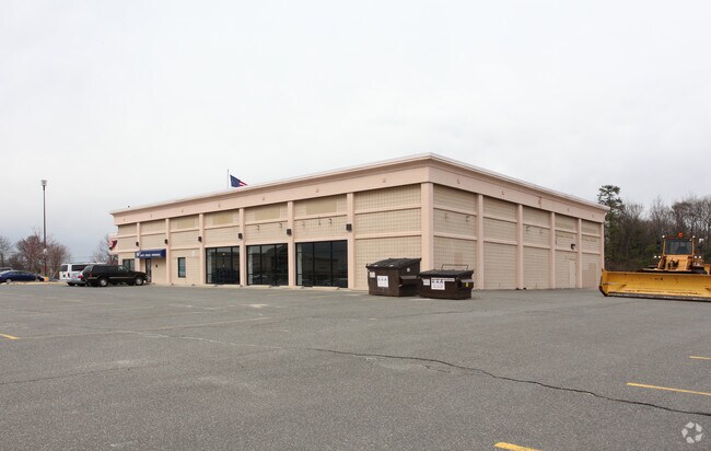
Property Detail
270 Cooley St
Restaurantbuilding
Hampden
SR1B1
Massachusetts
B and X Area of moderate flood hazard, usually the area between the limits of the 100-year and 500-year floods.
0.51 AC
2025
Hampden County
2025
Hartford
801605
Springfield, MA
8,800 SF
SPRI-003170-000000-000032
NEARBY LISTINGS FOR SALE OR LEASE
DEMOGRAPHICS near 270 Cooley St
1 mile
3 mile
5 mile
2024 Total Population
7,428
71,660
181,652
2029 Population
7,417
71,717
181,655
Pop Growth 2024-2029
(0.15%)
+ 0.08%
0.00%
Average Age
41
40
40
2024 Total Households
2,853
26,507
68,377
HH Growth 2024-2029
(0.21%)
0.00%
(0.03%)
Median Household Inc
$82,875
$78,052
$62,942
Avg Household Size
2.50
2.50
2.50
2024 Avg HH Vehicles
2.00
2.00
2.00
Median Home Value
$287,564
$276,373
$286,702
Median Year Built
1958
1957
1954
Nearby Places
Map Layers
Map Styles
 Street
 Aerial
Transit
 Traffic
 Biking
Places
Listings with unknown addresses are not visible on the map
- Restaurants
- Banks
- Shops
- Fitness
- Groceries
PUBLIC TRANSPORTATION
COMMUTER RAIL
Drive
Walk
Distance
11 min
6.0 mi
AIRPORT
Bradley International
Drive
Walk
Distance
Bradley International
38 min
19.8 mi
Worcester Regional
Drive
Walk
Distance
Worcester Regional
73 min
49.7 mi
SALE & LEASE HISTORY
LISTING DATE
SALE/LEASE

Apr 21, 2017
For Lease
Nearby Properties
Address
Land Use
TOTAL SIZE
Lot Size
Zoning
Address
Land Use
TOTAL SIZE
Lot Size
Zoning
89,312 SF
38.72 AC
R1
Address
Land Use
TOTAL SIZE
Lot Size
Zoning
248,182 SF
46.27 AC
R34
Address
Land Use
TOTAL SIZE
Lot Size
Zoning
207,383 SF
37.44 AC
R6
Address
Land Use
TOTAL SIZE
Lot Size
Zoning
431,476 SF
88.64 AC
SC2B1
Address
Land Use
TOTAL SIZE
Lot Size
Zoning
56,576 SF
62.84 AC
SR1R4
Address
Land Use
TOTAL SIZE
Lot Size
Zoning
1.89 AC
SR2I2
Address
Land Use
TOTAL SIZE
Lot Size
Zoning
36,446 SF
25 AC
R1
Address
Land Use
TOTAL SIZE
Lot Size
Zoning
153,742 SF
22.34 AC
R1
Address
Land Use
TOTAL SIZE
Lot Size
Zoning
232,510 SF
61.40 AC
RB
Address
Land Use
TOTAL SIZE
Lot Size
Zoning
127,645 SF
20 AC
RC
Address
Land Use
TOTAL SIZE
Lot Size
Zoning
5,802 SF
49.19 AC
R2
Address
Land Use
TOTAL SIZE
Lot Size
Zoning
196,530 SF
19.74 AC
SR1C1
Address
Land Use
TOTAL SIZE
Lot Size
Zoning
102,932 SF
60.01 AC
R6
Address
Land Use
TOTAL SIZE
Lot Size
Zoning
27,200 SF
13.22 AC
MULT
Address
Land Use
TOTAL SIZE
Lot Size
Zoning
105,000 SF
17.59 AC
SR1R3
Address
Land Use
TOTAL SIZE
Lot Size
Zoning
40,212 SF
5.12 AC
R6
Address
Land Use
TOTAL SIZE
Lot Size
Zoning
38,850 SF
10.06 AC
R1
Address
Land Use
TOTAL SIZE
Lot Size
Zoning
10,344 SF
9.54 AC
R4
Address
Land Use
TOTAL SIZE
Lot Size
Zoning
11,115 SF
57.72 AC
R1
Address
Land Use
TOTAL SIZE
Lot Size
Zoning
62,115 SF
1.69 AC
R1
Address
Land Use
TOTAL SIZE
Lot Size
Zoning
55,881 SF
2 AC
R2
Address
Land Use
TOTAL SIZE
Lot Size
Zoning
34,732 SF
24.73 AC
R1
Address
Land Use
TOTAL SIZE
Lot Size
Zoning
47,458 SF
3.87 AC
R1
Address
Land Use
TOTAL SIZE
Lot Size
Zoning
62,262 SF
18.69 AC
SR1R4
Address
Land Use
TOTAL SIZE
Lot Size
Zoning
39,860 SF
3.94 AC
R1
Address
Land Use
TOTAL SIZE
Lot Size
Zoning
37,404 SF
10.26 AC
R1
Address
Land Use
TOTAL SIZE
Lot Size
Zoning
15,360 SF
3.62 AC
R1
Address
Land Use
TOTAL SIZE
Lot Size
Zoning
144,253 SF
32.19 AC
SR2B1
Address
Land Use
TOTAL SIZE
Lot Size
Zoning
73,150 SF
21.61 AC
RA
Address
Land Use
TOTAL SIZE
Lot Size
Zoning
19,122 SF
2.30 AC
R2
The World's #1 Commercial Real Estate Marketplace
Connect with us
© 2026 CoStar Group
The information above has been obtained from sources believed reliable. While we do not doubt its accuracy we have not verified it and make no guarantee, warranty or representation about it. It is your responsibility to independently confirm its accuracy and completeness. Any projections, opinions, assumptions, or estimates used are for example only and do not represent the current or future performance of the property. The value of this transaction to you depends on tax and other factors which should be evaluated by your tax, financial, and legal advisors. You and your advisors should conduct a careful, independent investigation of the property to determine to your satisfaction the suitability of the property for your needs.