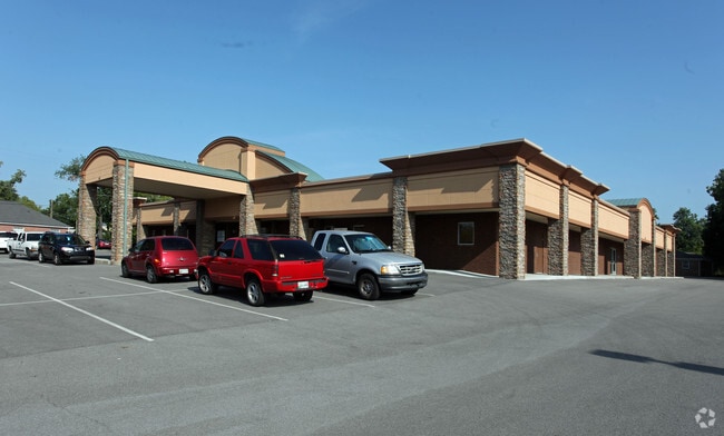
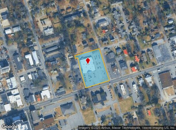
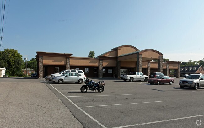
Property Record
270 E Main St, Gallatin, TN 37066
NEARBY LISTINGS FOR SALE OR LEASE
Property Detail
270 E Main St
126C-E-017.00
DISTRICT: 03 RAI DIALYSIS CENTER, COUNTY AREA: B01
Medicalbuilding
Sumner
X
Tennessee
47165C0314G
2.31 AC
2024
Rivergate/Hendersonville
2025
Nashville
020700
Nashville-Davidson--Murfreesboro--Franklin, TN
22,833 SF
DEMOGRAPHICS near 270 E Main St
1 Mile
3 Mile
5 Mile
2024 Total Population
9,244
34,464
51,899
2029 Population
10,271
38,526
58,207
Pop Growth 2024-2029
+ 11.11%
+ 11.79%
+ 12.15%
Average Age
37
39
41
2024 Total Households
3,488
13,339
20,391
HH Growth 2024-2029
+ 11.41%
+ 12.03%
+ 12.42%
Median Household Inc
$37,289
$50,514
$60,160
Avg Household Size
2.40
2.50
2.50
2024 Avg HH Vehicles
2.00
2.00
2.00
Median Home Value
$196,846
$269,405
$328,492
Median Year Built
1974
1989
1997
Nearby Places
Map Layers
Map Styles
 Street
 Aerial
- Restaurants
- Banks
- Shops
- Fitness
- Groceries
PUBLIC TRANSPORTATION
AIRPORT
Nashville International
DRIVE
WALK
Distance
Nashville International
44 min
32.3 mi
Nearby Properties
Address
Land Use
TOTAL SIZE
Lot Size
Zoning
Address
Land Use
TOTAL SIZE
Lot Size
Zoning
38,900 SF
11.14 AC
Address
Land Use
TOTAL SIZE
Lot Size
Zoning
27,816 SF
10.76 AC
MU
Address
Land Use
TOTAL SIZE
Lot Size
Zoning
52,475 SF
14.46 AC
Address
Land Use
TOTAL SIZE
Lot Size
Zoning
16,736 SF
14.10 AC
Address
Land Use
TOTAL SIZE
Lot Size
Zoning
5,992 SF
15.38 AC
Address
Land Use
TOTAL SIZE
Lot Size
Zoning
416,888 SF
42.88 AC
Address
Land Use
TOTAL SIZE
Lot Size
Zoning
10,320 SF
76.70 AC
IG
Address
Land Use
TOTAL SIZE
Lot Size
Zoning
10,656 SF
1.71 AC
R06
Address
Land Use
TOTAL SIZE
Lot Size
Zoning
205,182 SF
21.90 AC
CG
Address
Land Use
TOTAL SIZE
Lot Size
Zoning
7,424 SF
15.77 AC
Address
Land Use
TOTAL SIZE
Lot Size
Zoning
82,974 SF
11.19 AC
IR
Address
Land Use
TOTAL SIZE
Lot Size
Zoning
56,492 SF
4.72 AC
Address
Land Use
TOTAL SIZE
Lot Size
Zoning
426,312 SF
40 AC
IG
Address
Land Use
TOTAL SIZE
Lot Size
Zoning
9,568 SF
16.50 AC
Address
Land Use
TOTAL SIZE
Lot Size
Zoning
127,050 SF
Address
Land Use
TOTAL SIZE
Lot Size
Zoning
35,569 SF
6.99 AC
Address
Land Use
TOTAL SIZE
Lot Size
Zoning
20,000 SF
16.70 AC
Address
Land Use
TOTAL SIZE
Lot Size
Zoning
64,960 SF
15.11 AC
IG
Address
Land Use
TOTAL SIZE
Lot Size
Zoning
370,211 SF
28.30 AC
Address
Land Use
TOTAL SIZE
Lot Size
Zoning
106,660 SF
18.74 AC
IG
Address
Land Use
TOTAL SIZE
Lot Size
Zoning
18,016 SF
17.90 AC
Address
Land Use
TOTAL SIZE
Lot Size
Zoning
23,080 SF
2.07 AC
Address
Land Use
TOTAL SIZE
Lot Size
Zoning
63,334 SF
2.45 AC
Address
Land Use
TOTAL SIZE
Lot Size
Zoning
142,992 SF
18.11 AC
Address
Land Use
TOTAL SIZE
Lot Size
Zoning
865 SF
0.77 AC
Address
Land Use
TOTAL SIZE
Lot Size
Zoning
14,016 SF
13.91 AC
IR
Address
Land Use
TOTAL SIZE
Lot Size
Zoning
70,889 SF
7.02 AC
Address
Land Use
TOTAL SIZE
Lot Size
Zoning
65,933 SF
6.13 AC
Address
Land Use
TOTAL SIZE
Lot Size
Zoning
3,648 SF
25.70 AC
IR
Address
Land Use
TOTAL SIZE
Lot Size
Zoning
191,536 SF
22.40 AC
The World's #1 Commercial Real Estate Marketplace
Connect with us
© 2025 CoStar Group
The information above has been obtained from sources believed reliable. While we do not doubt its accuracy we have not verified it and make no guarantee, warranty or representation about it. It is your responsibility to independently confirm its accuracy and completeness. Any projections, opinions, assumptions, or estimates used are for example only and do not represent the current or future performance of the property. The value of this transaction to you depends on tax and other factors which should be evaluated by your tax, financial, and legal advisors. You and your advisors should conduct a careful, independent investigation of the property to determine to your satisfaction the suitability of the property for your needs.