Property Record
270 Lafayette Rd, Rye, NH 03870
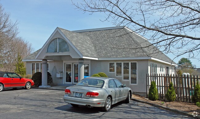

Property Detail
270 Lafayette Rd
Commercialbuilding
ROCKINGHAM
COM
New Hampshire
B and X Area of moderate flood hazard, usually the area between the limits of the 100-year and 500-year floods.
2.22 AC
2025
Rockingham
2025
Boston
071001
Boston-Cambridge-Newton, MA-NH
2,244 SF
RYEE-000010-000000-000083
NEARBY LISTINGS FOR SALE OR LEASE
DEMOGRAPHICS near 270 Lafayette Rd
1 mile
3 mile
5 mile
2025 Total Population
1,696
13,744
42,567
2030 Population
1,750
14,028
43,411
Pop Growth 2025-2030
+ 3.18%
+ 2.07%
+ 1.98%
Average Age
50
47
46
2025 Total Households
701
5,995
18,077
HH Growth 2025-2030
+ 3.00%
+ 1.97%
+ 1.93%
Median Household Inc
$87,980
$113,125
$115,932
Avg Household Size
2.30
2.30
2.30
2025 Avg HH Vehicles
2.00
2.00
2.00
Median Home Value
$759,533
$751,687
$723,198
Median Year Built
1985
1983
1978
Nearby Places
Map Layers
Map Styles
 Street
 Aerial
Layers
 Traffic
 Biking
Places
Listings with unknown addresses are not visible on the map
- Restaurants
- Banks
- Shops
- Fitness
- Groceries
PUBLIC TRANSPORTATION
COMMUTER RAIL
Exeter (Downeaster - Amtrak)
Drive
Walk
Distance
Exeter (Downeaster - Amtrak)
19 min
9.1 mi
AIRPORT
Portsmouth International at Pease
Drive
Walk
Distance
Portsmouth International at Pease
16 min
7.2 mi
Freight Ports
Port of Boston
Drive
Walk
Distance
Port of Boston
77 min
53.4 mi
Nearby Properties
Address
Land Use
TOTAL SIZE
Lot Size
Zoning
Address
Land Use
TOTAL SIZE
Lot Size
Zoning
35.53 AC
GA/MH
Address
Land Use
TOTAL SIZE
Lot Size
Zoning
28.05 AC
GA/MH
Address
Land Use
TOTAL SIZE
Lot Size
Zoning
108,362 SF
G1
Address
Land Use
TOTAL SIZE
Lot Size
Zoning
114,194 SF
G1
Address
Land Use
TOTAL SIZE
Lot Size
Zoning
33.39 AC
IND
Address
Land Use
TOTAL SIZE
Lot Size
Zoning
25.08 AC
NRP
Address
Land Use
TOTAL SIZE
Lot Size
Zoning
190,444 SF
20.38 AC
G1
Address
Land Use
TOTAL SIZE
Lot Size
Zoning
7.16 AC
GA/MH
Address
Land Use
TOTAL SIZE
Lot Size
Zoning
53,008 SF
17.70 AC
SRES
Address
Land Use
TOTAL SIZE
Lot Size
Zoning
72,193 SF
G1
Address
Land Use
TOTAL SIZE
Lot Size
Zoning
72,694 SF
36.70 AC
I
Address
Land Use
TOTAL SIZE
Lot Size
Zoning
85,152 SF
13.04 AC
G1
Address
Land Use
TOTAL SIZE
Lot Size
Zoning
143,468 SF
61.40 AC
IB/R
Address
Land Use
TOTAL SIZE
Lot Size
Zoning
207,279 SF
33.07 AC
I
Address
Land Use
TOTAL SIZE
Lot Size
Zoning
132,784 SF
22.32 AC
IND
Address
Land Use
TOTAL SIZE
Lot Size
Zoning
107,657 SF
8.67 AC
IND
Address
Land Use
TOTAL SIZE
Lot Size
Zoning
24,810 SF
10.75 AC
I
Address
Land Use
TOTAL SIZE
Lot Size
Zoning
1,740 SF
67.09 AC
GA/MH
Address
Land Use
TOTAL SIZE
Lot Size
Zoning
114,814 SF
12.19 AC
IB/R
Address
Land Use
TOTAL SIZE
Lot Size
Zoning
21,318 SF
3.98 AC
OR
Address
Land Use
TOTAL SIZE
Lot Size
Zoning
6,572 SF
2.32 AC
SRES
Address
Land Use
TOTAL SIZE
Lot Size
Zoning
64.57 AC
I
Address
Land Use
TOTAL SIZE
Lot Size
Zoning
3.80 AC
G1
Address
Land Use
TOTAL SIZE
Lot Size
Zoning
4.79 AC
I
Address
Land Use
TOTAL SIZE
Lot Size
Zoning
Address
Land Use
TOTAL SIZE
Lot Size
Zoning
83,021 SF
3.54 AC
RES
Address
Land Use
TOTAL SIZE
Lot Size
Zoning
69,745 SF
85.26 AC
R2
Address
Land Use
TOTAL SIZE
Lot Size
Zoning
33,716 SF
G1
Address
Land Use
TOTAL SIZE
Lot Size
Zoning
34,359 SF
10.15 AC
COM
Address
Land Use
TOTAL SIZE
Lot Size
Zoning
1,699 SF
9.61 AC
IB/R
The World's #1 Commercial Real Estate Marketplace
Connect with us
© 2026 CoStar Group
The information above has been obtained from sources believed reliable. While we do not doubt its accuracy we have not verified it and make no guarantee, warranty or representation about it. It is your responsibility to independently confirm its accuracy and completeness. Any projections, opinions, assumptions, or estimates used are for example only and do not represent the current or future performance of the property. The value of this transaction to you depends on tax and other factors which should be evaluated by your tax, financial, and legal advisors. You and your advisors should conduct a careful, independent investigation of the property to determine to your satisfaction the suitability of the property for your needs.