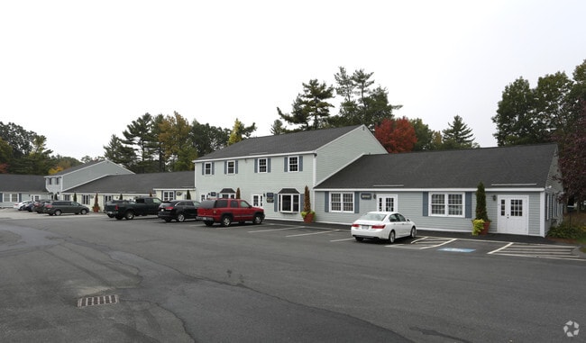
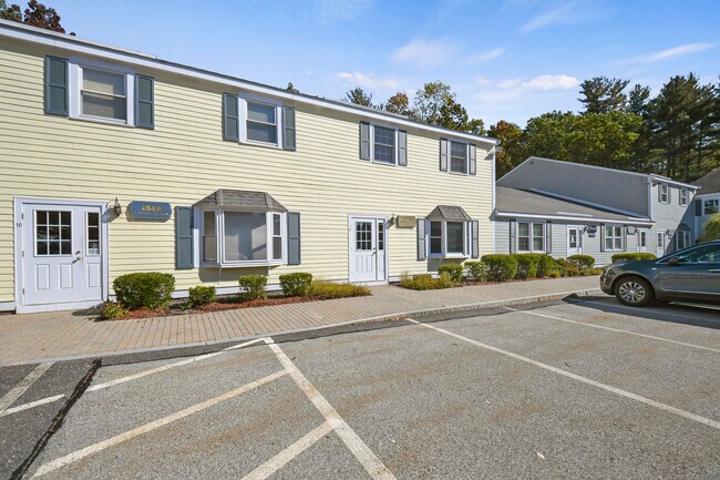
Property Record
270 Littleton Rd, Chelmsford, MA 01824
NEARBY LISTINGS FOR SALE OR LEASE
Property Detail
270 Littleton Rd
CHEL-000100-000389-000011
Plan 9771A
Multifamilydwelling
Middlesex
AE
Massachusetts
25017C0234F
37.75 AC
2025
Lowell/Chelmsford
2025
Boston
318400
Boston-Cambridge-Newton, MA-NH
DEMOGRAPHICS near 270 Littleton Rd
1 Mile
3 Mile
5 Mile
2024 Total Population
1,505
22,379
64,845
2029 Population
1,490
22,252
64,511
Pop Growth 2024-2029
(1.00%)
(0.57%)
(0.52%)
Average Age
42
42
42
2024 Total Households
528
8,257
23,704
HH Growth 2024-2029
(1.33%)
(0.63%)
(0.62%)
Median Household Inc
$180,722
$150,416
$152,398
Avg Household Size
2.80
2.70
2.70
2024 Avg HH Vehicles
2.00
2.00
2.00
Median Home Value
$704,838
$655,801
$670,386
Median Year Built
1989
1986
1978
Nearby Places
Map Layers
Map Styles
 Street
 Aerial
- Restaurants
- Banks
- Shops
- Fitness
- Groceries
PUBLIC TRANSPORTATION
COMMUTER RAIL
Lowell (Lowell Line - Massachusetts Bay Transportation Authority Commuter Rail (Purple Line))
DRIVE
WALK
Distance
Lowell (Lowell Line - Massachusetts Bay Transportation Authority Commuter Rail (Purple Line))
10 min
5.5 mi
North Billerica (Lowell Line - Massachusetts Bay Transportation Authority Commuter Rail (Purple Line))
DRIVE
WALK
Distance
North Billerica (Lowell Line - Massachusetts Bay Transportation Authority Commuter Rail (Purple Line))
12 min
6.4 mi
AIRPORT
Manchester Boston Regional
DRIVE
WALK
Distance
Manchester Boston Regional
48 min
31.2 mi
General Edward Lawrence Logan International
DRIVE
WALK
Distance
General Edward Lawrence Logan International
49 min
36.9 mi
Freight Ports
Port of Boston
DRIVE
WALK
Distance
Port of Boston
50 min
36.6 mi
SALE & LEASE HISTORY
LISTING DATE
SALE/LEASE

Sep 27, 2018
For Sale
Sep 25, 2016
For Lease
Sep 25, 2016
For Lease
Mar 11, 2020
For Lease
Aug 05, 2017
For Sale
Aug 05, 2017
For Sale
Apr 10, 2019
For Sale
Nearby Properties
Address
Land Use
TOTAL SIZE
Lot Size
Zoning
Address
Land Use
TOTAL SIZE
Lot Size
Zoning
205,340 SF
44.73 AC
RA
Address
Land Use
TOTAL SIZE
Lot Size
Zoning
255,627 SF
82.71 AC
RA
Address
Land Use
TOTAL SIZE
Lot Size
Zoning
174 SF
IA
Address
Land Use
TOTAL SIZE
Lot Size
Zoning
269,952 SF
18.11 AC
P
Address
Land Use
TOTAL SIZE
Lot Size
Zoning
220,257 SF
24.17 AC
CH
Address
Land Use
TOTAL SIZE
Lot Size
Zoning
38.26 AC
P
Address
Land Use
TOTAL SIZE
Lot Size
Zoning
7.41 AC
CB
Address
Land Use
TOTAL SIZE
Lot Size
Zoning
161,850 SF
18.41 AC
CH
Address
Land Use
TOTAL SIZE
Lot Size
Zoning
85,450 SF
32.07 AC
RA
Address
Land Use
TOTAL SIZE
Lot Size
Zoning
9.48 AC
RB
Address
Land Use
TOTAL SIZE
Lot Size
Zoning
230,037 SF
18.85 AC
IH
Address
Land Use
TOTAL SIZE
Lot Size
Zoning
64,542 SF
4.67 AC
CH
Address
Land Use
TOTAL SIZE
Lot Size
Zoning
73,576 SF
26.14 AC
P
Address
Land Use
TOTAL SIZE
Lot Size
Zoning
95,220 SF
6.31 AC
CC
Address
Land Use
TOTAL SIZE
Lot Size
Zoning
82,182 SF
13.86 AC
P
Address
Land Use
TOTAL SIZE
Lot Size
Zoning
58,766 SF
21.98 AC
RA
Address
Land Use
TOTAL SIZE
Lot Size
Zoning
181,578 SF
11.40 AC
IH
Address
Land Use
TOTAL SIZE
Lot Size
Zoning
59,848 SF
6.30 AC
P
Address
Land Use
TOTAL SIZE
Lot Size
Zoning
62,620 SF
13.20 AC
P
Address
Land Use
TOTAL SIZE
Lot Size
Zoning
87,430 SF
9.30 AC
CH
Address
Land Use
TOTAL SIZE
Lot Size
Zoning
130,524 SF
19.74 AC
IH
Address
Land Use
TOTAL SIZE
Lot Size
Zoning
8.54 AC
CB
Address
Land Use
TOTAL SIZE
Lot Size
Zoning
27.80 AC
P
Address
Land Use
TOTAL SIZE
Lot Size
Zoning
57,700 SF
8.27 AC
CH
Address
Land Use
TOTAL SIZE
Lot Size
Zoning
43,775 SF
8.69 AC
P
Address
Land Use
TOTAL SIZE
Lot Size
Zoning
4.53 AC
CB
Address
Land Use
TOTAL SIZE
Lot Size
Zoning
47,524 SF
6.03 AC
P
Address
Land Use
TOTAL SIZE
Lot Size
Zoning
72,854 SF
1.96 AC
RM
Address
Land Use
TOTAL SIZE
Lot Size
Zoning
90,250 SF
7.57 AC
IA
The World's #1 Commercial Real Estate Marketplace
Connect with us
© 2026 CoStar Group
The information above has been obtained from sources believed reliable. While we do not doubt its accuracy we have not verified it and make no guarantee, warranty or representation about it. It is your responsibility to independently confirm its accuracy and completeness. Any projections, opinions, assumptions, or estimates used are for example only and do not represent the current or future performance of the property. The value of this transaction to you depends on tax and other factors which should be evaluated by your tax, financial, and legal advisors. You and your advisors should conduct a careful, independent investigation of the property to determine to your satisfaction the suitability of the property for your needs.