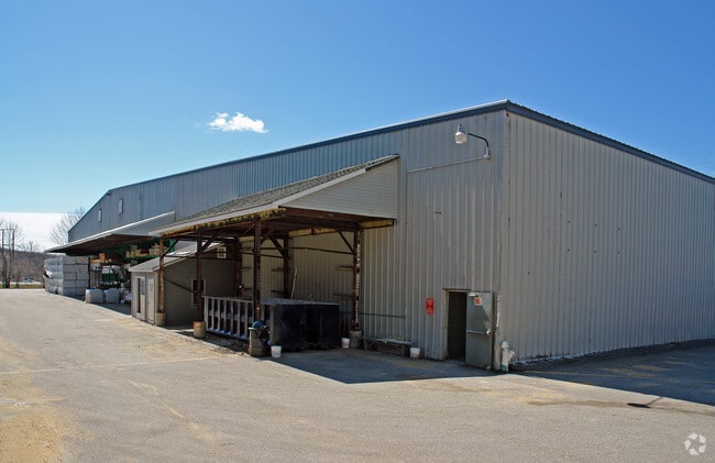
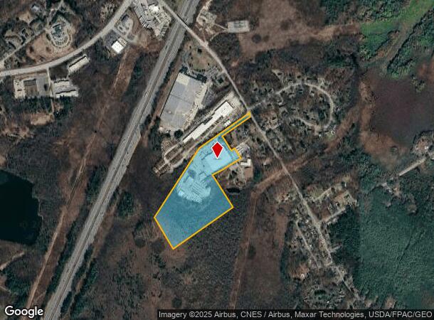
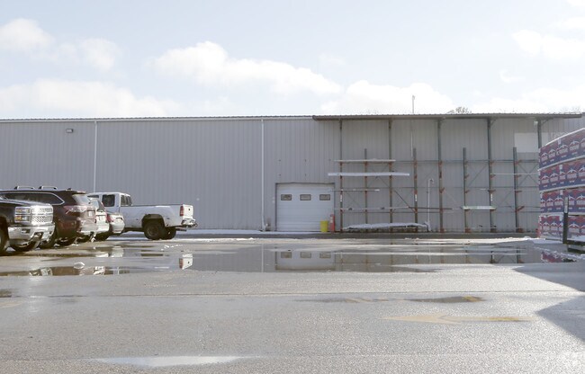
Property Record
270 Ocean Rd, Greenland, NH 03840
NEARBY LISTINGS FOR SALE OR LEASE
Property Detail
270 Ocean Rd
GRNL-000000-000020-000006-A000000-R
Rockingham
Industrialgeneral
New Hampshire
A
6-a
33015C0265F
28.02 AC
2024
Rockingham
2024
Boston
107500
Boston-Cambridge-Newton, MA-NH
DEMOGRAPHICS near 270 Ocean Rd
1 Mile
3 Mile
5 Mile
2024 Total Population
832
15,707
44,984
2029 Population
864
16,384
46,990
Pop Growth 2024-2029
+ 3.85%
+ 4.31%
+ 4.46%
Average Age
44
44
45
2024 Total Households
347
6,685
19,837
HH Growth 2024-2029
+ 3.75%
+ 4.26%
+ 4.43%
Median Household Inc
$117,934
$111,402
$109,744
Avg Household Size
2.40
2.30
2.20
2024 Avg HH Vehicles
2.00
2.00
2.00
Median Home Value
$498,147
$564,858
$645,087
Median Year Built
1980
1980
1972
Nearby Places
Map Layers
Map Styles
 Street
 Aerial
- Restaurants
- Banks
- Shops
- Fitness
- Groceries
PUBLIC TRANSPORTATION
AIRPORT
Portsmouth International at Pease
DRIVE
WALK
Distance
Portsmouth International at Pease
11 min
4.4 mi
Manchester Boston Regional
DRIVE
WALK
Distance
Manchester Boston Regional
65 min
43.2 mi
Freight Ports
Portland, ME
DRIVE
WALK
Distance
Portland, ME
68 min
55.6 mi
Nearby Properties
Address
Land Use
TOTAL SIZE
Lot Size
Zoning
Address
Land Use
TOTAL SIZE
Lot Size
Zoning
54.20 AC
M
Address
Land Use
TOTAL SIZE
Lot Size
Zoning
35.53 AC
GA/MH
Address
Land Use
TOTAL SIZE
Lot Size
Zoning
28.05 AC
GA/MH
Address
Land Use
TOTAL SIZE
Lot Size
Zoning
114,194 SF
G1
Address
Land Use
TOTAL SIZE
Lot Size
Zoning
11.23 AC
OR
Address
Land Use
TOTAL SIZE
Lot Size
Zoning
33.39 AC
IND
Address
Land Use
TOTAL SIZE
Lot Size
Zoning
25.08 AC
NRP
Address
Land Use
TOTAL SIZE
Lot Size
Zoning
15.20 AC
G1
Address
Land Use
TOTAL SIZE
Lot Size
Zoning
190,444 SF
20.38 AC
G1
Address
Land Use
TOTAL SIZE
Lot Size
Zoning
137,809 SF
13.18 AC
ABC
Address
Land Use
TOTAL SIZE
Lot Size
Zoning
204,800 SF
ABC
Address
Land Use
TOTAL SIZE
Lot Size
Zoning
7.16 AC
GA/MH
Address
Land Use
TOTAL SIZE
Lot Size
Zoning
112,872 SF
9.43 AC
G1
Address
Land Use
TOTAL SIZE
Lot Size
Zoning
53,008 SF
17.70 AC
SRES
Address
Land Use
TOTAL SIZE
Lot Size
Zoning
72,193 SF
G1
Address
Land Use
TOTAL SIZE
Lot Size
Zoning
2.67 AC
CD4-W
Address
Land Use
TOTAL SIZE
Lot Size
Zoning
89,689 SF
9.17 AC
G2
Address
Land Use
TOTAL SIZE
Lot Size
Zoning
53,916 SF
I
Address
Land Use
TOTAL SIZE
Lot Size
Zoning
7.94 AC
GA/MH
Address
Land Use
TOTAL SIZE
Lot Size
Zoning
50,496 SF
I
Address
Land Use
TOTAL SIZE
Lot Size
Zoning
20.53 AC
PI
Address
Land Use
TOTAL SIZE
Lot Size
Zoning
72,694 SF
36.70 AC
I
Address
Land Use
TOTAL SIZE
Lot Size
Zoning
85,152 SF
13.04 AC
G1
Address
Land Use
TOTAL SIZE
Lot Size
Zoning
108,116 SF
18.48 AC
IND
Address
Land Use
TOTAL SIZE
Lot Size
Zoning
207,279 SF
33.07 AC
I
Address
Land Use
TOTAL SIZE
Lot Size
Zoning
39,536 SF
18.22 AC
GB
Address
Land Use
TOTAL SIZE
Lot Size
Zoning
99,104 SF
7.31 AC
ABC
Address
Land Use
TOTAL SIZE
Lot Size
Zoning
50,700 SF
5.32 AC
OR
Address
Land Use
TOTAL SIZE
Lot Size
Zoning
53,616 SF
19.17 AC
M
Address
Land Use
TOTAL SIZE
Lot Size
Zoning
95,884 SF
22.02 AC
ABC
The World's #1 Commercial Real Estate Marketplace
Connect with us
© 2026 CoStar Group
The information above has been obtained from sources believed reliable. While we do not doubt its accuracy we have not verified it and make no guarantee, warranty or representation about it. It is your responsibility to independently confirm its accuracy and completeness. Any projections, opinions, assumptions, or estimates used are for example only and do not represent the current or future performance of the property. The value of this transaction to you depends on tax and other factors which should be evaluated by your tax, financial, and legal advisors. You and your advisors should conduct a careful, independent investigation of the property to determine to your satisfaction the suitability of the property for your needs.