Property Record
270 Samuel Barnet Blvd, New Bedford, MA 02745
NEARBY LISTINGS FOR SALE OR LEASE
-
-
View all New Bedford listings for sale on LoopNet.com
Property Detail
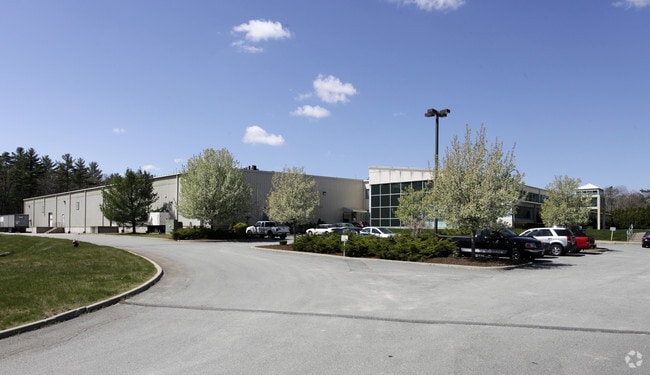
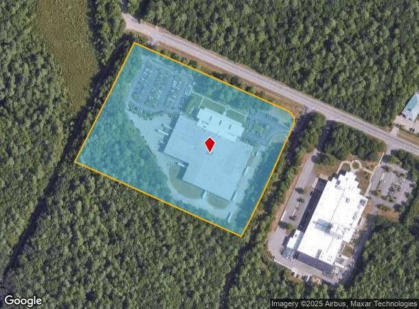
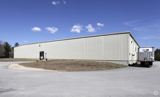
270 Samuel Barnet Blvd
DART-000084-000008-000005
Dartmouth
Manufacturinglight
Bristol
X
Massachusetts
25005C0376G
5
2025
14.91 AC
2025
Attleboro/New Bedford
653102
Boston
93,480 SF
Providence-Warwick, RI-MA
DEMOGRAPHICS near 270 Samuel Barnet Blvd
1 Mile
3 Mile
5 Mile
2024 Total Population
275
15,636
57,712
2029 Population
273
15,544
56,830
Pop Growth 2024-2029
(0.73%)
(0.59%)
(1.53%)
Average Age
42
42
41
2024 Total Households
94
6,080
22,922
HH Growth 2024-2029
(1.06%)
(0.59%)
(1.60%)
Median Household Inc
$118,749
$87,880
$68,160
Avg Household Size
2.90
2.50
2.40
2024 Avg HH Vehicles
3.00
2.00
2.00
Median Home Value
$491,999
$359,486
$345,967
Median Year Built
1987
1981
1961
Nearby Places
Map Layers
Map Styles
 Street
 Aerial
- Restaurants
- Banks
- Shops
- Fitness
- Groceries
PUBLIC TRANSPORTATION
AIRPORT
Rhode Island Tf Green International
DRIVE
WALK
Distance
Rhode Island Tf Green International
64 min
41.7 mi
Nearby Properties
Address
Land Use
TOTAL SIZE
Lot Size
Zoning
Address
Land Use
TOTAL SIZE
Lot Size
Zoning
23.22 AC
RB
Address
Land Use
TOTAL SIZE
Lot Size
Zoning
2,295.68 AC
R-80
Address
Land Use
TOTAL SIZE
Lot Size
Zoning
157,346 SF
5.68 AC
RA
Address
Land Use
TOTAL SIZE
Lot Size
Zoning
44,156 SF
5.18 AC
GI
Address
Land Use
TOTAL SIZE
Lot Size
Zoning
31.14 AC
R
Address
Land Use
TOTAL SIZE
Lot Size
Zoning
492.70 AC
IC
Address
Land Use
TOTAL SIZE
Lot Size
Zoning
225,292 SF
29.27 AC
IC
Address
Land Use
TOTAL SIZE
Lot Size
Zoning
239,765 SF
31.86 AC
IC
Address
Land Use
TOTAL SIZE
Lot Size
Zoning
306.30 AC
IC
Address
Land Use
TOTAL SIZE
Lot Size
Zoning
6.46 AC
MUB
Address
Land Use
TOTAL SIZE
Lot Size
Zoning
199,978 SF
31.41 AC
IC
Address
Land Use
TOTAL SIZE
Lot Size
Zoning
169,928 SF
31.88 AC
GI
Address
Land Use
TOTAL SIZE
Lot Size
Zoning
5,208 SF
152.06 AC
GI
Address
Land Use
TOTAL SIZE
Lot Size
Zoning
118,757 SF
61.52 AC
IC
Address
Land Use
TOTAL SIZE
Lot Size
Zoning
6.34 AC
RA
Address
Land Use
TOTAL SIZE
Lot Size
Zoning
62,408 SF
12.60 AC
RA
Address
Land Use
TOTAL SIZE
Lot Size
Zoning
95,972 SF
9.40 AC
IC
Address
Land Use
TOTAL SIZE
Lot Size
Zoning
5.64 AC
MUB
Address
Land Use
TOTAL SIZE
Lot Size
Zoning
4,041 SF
31.91 AC
Address
Land Use
TOTAL SIZE
Lot Size
Zoning
51,243 SF
8.51 AC
RA
Address
Land Use
TOTAL SIZE
Lot Size
Zoning
136,521 SF
18.46 AC
IC
Address
Land Use
TOTAL SIZE
Lot Size
Zoning
54,513 SF
4.28 AC
IA
Address
Land Use
TOTAL SIZE
Lot Size
Zoning
114,908 SF
14.19 AC
IC
Address
Land Use
TOTAL SIZE
Lot Size
Zoning
46,083 SF
8.43 AC
MUB
Address
Land Use
TOTAL SIZE
Lot Size
Zoning
72,764 SF
17.88 AC
GI
Address
Land Use
TOTAL SIZE
Lot Size
Zoning
71 AC
R
Address
Land Use
TOTAL SIZE
Lot Size
Zoning
310.20 AC
RA
Address
Land Use
TOTAL SIZE
Lot Size
Zoning
39,345 SF
0.79 AC
MUB
Address
Land Use
TOTAL SIZE
Lot Size
Zoning
59 AC
R
Address
Land Use
TOTAL SIZE
Lot Size
Zoning
37,824 SF
1.55 AC
MUB
The World's #1 Commercial Real Estate Marketplace
Connect with us
© 2026 CoStar Group
The information above has been obtained from sources believed reliable. While we do not doubt its accuracy we have not verified it and make no guarantee, warranty or representation about it. It is your responsibility to independently confirm its accuracy and completeness. Any projections, opinions, assumptions, or estimates used are for example only and do not represent the current or future performance of the property. The value of this transaction to you depends on tax and other factors which should be evaluated by your tax, financial, and legal advisors. You and your advisors should conduct a careful, independent investigation of the property to determine to your satisfaction the suitability of the property for your needs.