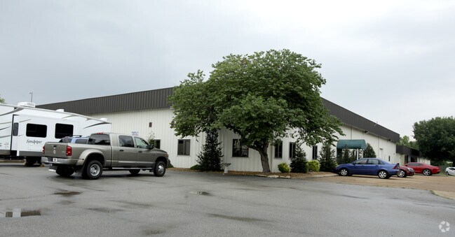
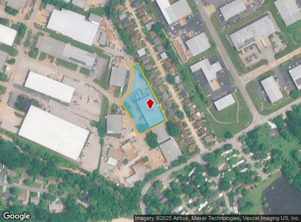
Property Record
270 Seebold Spur, Fenton, MO 63026

NEARBY LISTINGS FOR SALE OR LEASE
Property Detail
270 Seebold Spur
St. Louis, MO-IL
Sun Valley Industrial Center
02-2.0-04.0-4-001-013.10
SUN VALLEY INDUSTRIAL CENTER LOT 2
Industrialgeneral
Jefferson
X
Missouri
29099C0102F
2
2024
1.38 AC
2025
Jefferson County
700210
St. Louis
17,100 SF
DEMOGRAPHICS near 270 Seebold Spur
1 Mile
3 Mile
5 Mile
2024 Total Population
6,473
45,863
93,718
2029 Population
6,572
46,158
94,175
Pop Growth 2024-2029
+ 1.53%
+ 0.64%
+ 0.49%
Average Age
41
41
43
2024 Total Households
2,613
17,790
37,309
HH Growth 2024-2029
+ 1.76%
+ 0.77%
+ 0.53%
Median Household Inc
$69,163
$81,266
$82,588
Avg Household Size
2.40
2.50
2.40
2024 Avg HH Vehicles
2.00
2.00
2.00
Median Home Value
$198,484
$252,745
$266,633
Median Year Built
1986
1985
1983
Nearby Places
Map Layers
Map Styles
 Street
 Aerial
- Restaurants
- Banks
- Shops
- Fitness
- Groceries
PUBLIC TRANSPORTATION
COMMUTER RAIL
DRIVE
WALK
Distance
18 min
9.9 mi
AIRPORT
St Louis Lambert International
DRIVE
WALK
Distance
St Louis Lambert International
39 min
25.2 mi
Scott AFB/Midamerica St Louis
DRIVE
WALK
Distance
Scott AFB/Midamerica St Louis
65 min
45.9 mi
Nearby Properties
Address
Land Use
TOTAL SIZE
Lot Size
Zoning
Address
Land Use
TOTAL SIZE
Lot Size
Zoning
429,212 SF
53.13 AC
C-8
Address
Land Use
TOTAL SIZE
Lot Size
Zoning
62.50 AC
NU
Address
Land Use
TOTAL SIZE
Lot Size
Zoning
258,312 SF
16.34 AC
CC2
Address
Land Use
TOTAL SIZE
Lot Size
Zoning
139,212 SF
15.58 AC
21C-1
Address
Land Use
TOTAL SIZE
Lot Size
Zoning
112,840 SF
0.54 AC
C-8
Address
Land Use
TOTAL SIZE
Lot Size
Zoning
26.56 AC
NU
Address
Land Use
TOTAL SIZE
Lot Size
Zoning
154,844 SF
13.29 AC
21OT-3
Address
Land Use
TOTAL SIZE
Lot Size
Zoning
129,090 SF
17.78 AC
21C-1
Address
Land Use
TOTAL SIZE
Lot Size
Zoning
211,612 SF
41.36 AC
PB
Address
Land Use
TOTAL SIZE
Lot Size
Zoning
221,724 SF
21.98 AC
21OT-4
Address
Land Use
TOTAL SIZE
Lot Size
Zoning
265,291 SF
14.91 AC
PR2
Address
Land Use
TOTAL SIZE
Lot Size
Zoning
164,166 SF
16.88 AC
21C-1
Address
Land Use
TOTAL SIZE
Lot Size
Zoning
118,820 SF
13.30 AC
Address
Land Use
TOTAL SIZE
Lot Size
Zoning
156,592 SF
9.80 AC
PR2
Address
Land Use
TOTAL SIZE
Lot Size
Zoning
396 SF
61.20 AC
A
Address
Land Use
TOTAL SIZE
Lot Size
Zoning
99,230 SF
17.56 AC
HP1
Address
Land Use
TOTAL SIZE
Lot Size
Zoning
90,300 SF
9.42 AC
21OT-3
Address
Land Use
TOTAL SIZE
Lot Size
Zoning
20.85 AC
AFP
Address
Land Use
TOTAL SIZE
Lot Size
Zoning
94,421 SF
10.94 AC
21OT-2
Address
Land Use
TOTAL SIZE
Lot Size
Zoning
75,885 SF
7.75 AC
J1
Address
Land Use
TOTAL SIZE
Lot Size
Zoning
134,885 SF
16.91 AC
21C-1
Address
Land Use
TOTAL SIZE
Lot Size
Zoning
54,348 SF
6.61 AC
C-8
Address
Land Use
TOTAL SIZE
Lot Size
Zoning
125,762 SF
10.42 AC
21C-1
Address
Land Use
TOTAL SIZE
Lot Size
Zoning
97,476 SF
4.13 AC
R-3
Address
Land Use
TOTAL SIZE
Lot Size
Zoning
66,785 SF
50 AC
21R-1
Address
Land Use
TOTAL SIZE
Lot Size
Zoning
195,508 SF
6.81 AC
21BP-3
Address
Land Use
TOTAL SIZE
Lot Size
Zoning
76,662 SF
35.89 AC
FPM1
Address
Land Use
TOTAL SIZE
Lot Size
Zoning
85,150 SF
8.62 AC
21R-6A
Address
Land Use
TOTAL SIZE
Lot Size
Zoning
12.62 AC
21R-1
Address
Land Use
TOTAL SIZE
Lot Size
Zoning
7.41 AC
R3
The World's #1 Commercial Real Estate Marketplace
Connect with us
© 2026 CoStar Group
The information above has been obtained from sources believed reliable. While we do not doubt its accuracy we have not verified it and make no guarantee, warranty or representation about it. It is your responsibility to independently confirm its accuracy and completeness. Any projections, opinions, assumptions, or estimates used are for example only and do not represent the current or future performance of the property. The value of this transaction to you depends on tax and other factors which should be evaluated by your tax, financial, and legal advisors. You and your advisors should conduct a careful, independent investigation of the property to determine to your satisfaction the suitability of the property for your needs.