Property Record
270 State Rd, West Bath, ME 04530
NEARBY LISTINGS FOR SALE OR LEASE
-
-
View all West Bath listings for lease on LoopNet.com
Property Detail
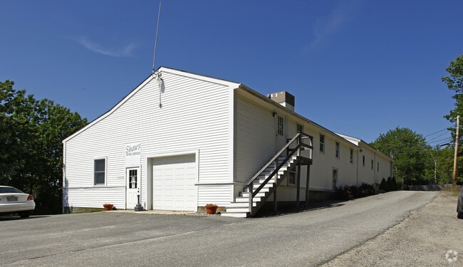
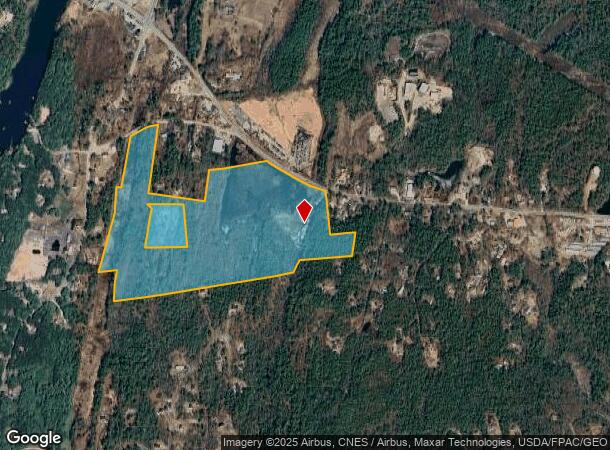
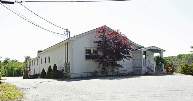
270 State Rd
WESH-000000-U000011-000022
Sagadahoc
Commercialnec
Maine
X
4.10 AC
23005C0388F
Sagadahoc County
2024
Portland/South Portland
2024
Portland-South Portland, ME
970700
DEMOGRAPHICS near 270 State Rd
1 Mile
3 Mile
5 Mile
2024 Total Population
644
14,290
24,628
2029 Population
674
14,916
25,781
Pop Growth 2024-2029
+ 4.66%
+ 4.38%
+ 4.68%
Average Age
46
44
43
2024 Total Households
287
6,555
10,602
HH Growth 2024-2029
+ 4.53%
+ 4.29%
+ 4.72%
Median Household Inc
$91,553
$64,058
$66,836
Avg Household Size
2.20
2.10
2.10
2024 Avg HH Vehicles
2.00
2.00
2.00
Median Home Value
$375,925
$249,607
$279,794
Median Year Built
1981
1965
1973
Nearby Places
Map Layers
Map Styles
 Street
 Aerial
- Restaurants
- Banks
- Shops
- Fitness
- Groceries
PUBLIC TRANSPORTATION
COMMUTER RAIL
DRIVE
WALK
Distance
12 min
7.7 mi
AIRPORT
Portland International Jetport
DRIVE
WALK
Distance
Portland International Jetport
52 min
38.4 mi
Freight Ports
Portland, ME
DRIVE
WALK
Distance
Portland, ME
46 min
35.4 mi
SALE & LEASE HISTORY
LISTING DATE
SALE/LEASE

Jan 22, 2024
For Lease
Nearby Properties
Address
Land Use
TOTAL SIZE
Lot Size
Zoning
Address
Land Use
TOTAL SIZE
Lot Size
Zoning
180,000 SF
26.95 AC
S
Address
Land Use
TOTAL SIZE
Lot Size
Zoning
16 AC
I
Address
Land Use
TOTAL SIZE
Lot Size
Zoning
43,434 SF
127 AC
R1
Address
Land Use
TOTAL SIZE
Lot Size
Zoning
132,504 SF
113.20 AC
Address
Land Use
TOTAL SIZE
Lot Size
Zoning
116,612 SF
2.53 AC
R1
Address
Land Use
TOTAL SIZE
Lot Size
Zoning
252,409 SF
24.20 AC
Address
Land Use
TOTAL SIZE
Lot Size
Zoning
203,981 SF
28.41 AC
Address
Land Use
TOTAL SIZE
Lot Size
Zoning
61,453 SF
2.90 AC
C4
Address
Land Use
TOTAL SIZE
Lot Size
Zoning
84,327 SF
5.48 AC
S
Address
Land Use
TOTAL SIZE
Lot Size
Zoning
56,594 SF
C4
Address
Land Use
TOTAL SIZE
Lot Size
Zoning
160,000 SF
49.64 AC
GI
Address
Land Use
TOTAL SIZE
Lot Size
Zoning
56,848 SF
1.91 AC
C1
Address
Land Use
TOTAL SIZE
Lot Size
Zoning
67.39 AC
Address
Land Use
TOTAL SIZE
Lot Size
Zoning
53,478 SF
6.08 AC
C2
Address
Land Use
TOTAL SIZE
Lot Size
Zoning
206,533 SF
28 AC
Address
Land Use
TOTAL SIZE
Lot Size
Zoning
137,400 SF
34.70 AC
Address
Land Use
TOTAL SIZE
Lot Size
Zoning
22,688 SF
1.20 AC
C1
Address
Land Use
TOTAL SIZE
Lot Size
Zoning
75,860 SF
0.72 AC
Address
Land Use
TOTAL SIZE
Lot Size
Zoning
900 SF
100.78 AC
Address
Land Use
TOTAL SIZE
Lot Size
Zoning
1,623 SF
22.23 AC
PH
Address
Land Use
TOTAL SIZE
Lot Size
Zoning
38,528 SF
3.40 AC
C3
Address
Land Use
TOTAL SIZE
Lot Size
Zoning
35,840 SF
9.65 AC
C3
Address
Land Use
TOTAL SIZE
Lot Size
Zoning
6.80 AC
C2
Address
Land Use
TOTAL SIZE
Lot Size
Zoning
20,604 SF
2.60 AC
M
Address
Land Use
TOTAL SIZE
Lot Size
Zoning
3,370 SF
10.94 AC
GR1
Address
Land Use
TOTAL SIZE
Lot Size
Zoning
39,194 SF
0.59 AC
C1
Address
Land Use
TOTAL SIZE
Lot Size
Zoning
45,228 SF
7.40 AC
Address
Land Use
TOTAL SIZE
Lot Size
Zoning
12,533 SF
29 AC
R3
Address
Land Use
TOTAL SIZE
Lot Size
Zoning
1.78 AC
R2
Address
Land Use
TOTAL SIZE
Lot Size
Zoning
33,758 SF
5.40 AC
R1
The World's #1 Commercial Real Estate Marketplace
Connect with us
© 2026 CoStar Group
The information above has been obtained from sources believed reliable. While we do not doubt its accuracy we have not verified it and make no guarantee, warranty or representation about it. It is your responsibility to independently confirm its accuracy and completeness. Any projections, opinions, assumptions, or estimates used are for example only and do not represent the current or future performance of the property. The value of this transaction to you depends on tax and other factors which should be evaluated by your tax, financial, and legal advisors. You and your advisors should conduct a careful, independent investigation of the property to determine to your satisfaction the suitability of the property for your needs.