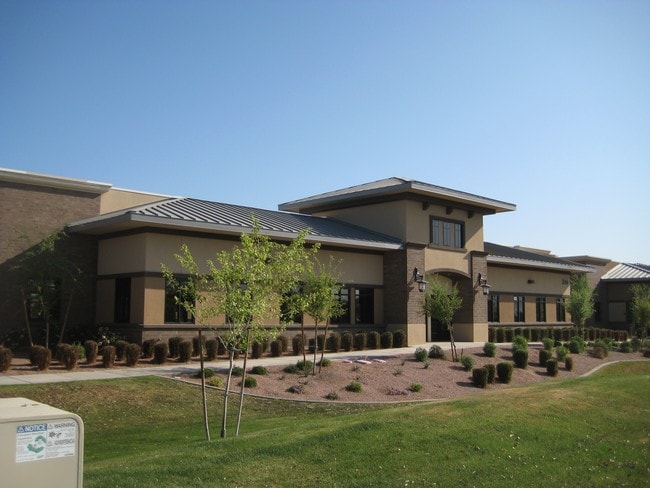
Property Record
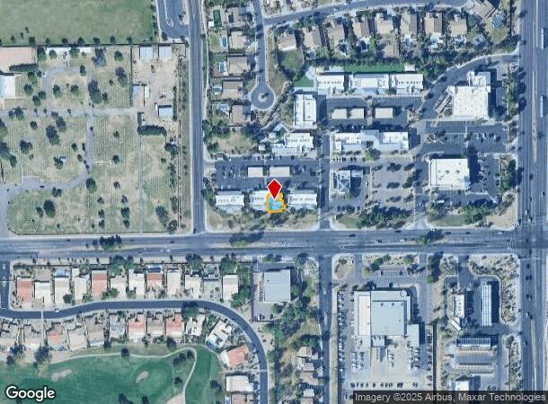
270 W Chandler Heights Rd, Chandler, AZ 85248

NEARBY LISTINGS FOR SALE OR LEASE
Property Detail
270 W Chandler Heights Rd
Phoenix-Mesa-Scottsdale, AZ
Marketplace Commons At Fulton Ranch Cond
303-54-666
MARKETPLACE COMMONS AT FULTON RANCH CONDOMINIUM MCR 1043-22
Officecondo
Maricopa
X
Arizona
04013C3105M
b102
2025
0.08 AC
2025
Chandler
813000
Phoenix
6,817 SF
DEMOGRAPHICS near 270 W Chandler Heights Rd
1 Mile
3 Mile
5 Mile
2024 Total Population
8,503
80,660
171,851
2029 Population
9,325
87,770
186,663
Pop Growth 2024-2029
+ 9.67%
+ 8.81%
+ 8.62%
Average Age
42
46
41
2024 Total Households
3,243
32,040
64,535
HH Growth 2024-2029
+ 10.18%
+ 9.08%
+ 8.77%
Median Household Inc
$125,086
$105,204
$103,093
Avg Household Size
2.60
2.50
2.60
2024 Avg HH Vehicles
2.00
2.00
2.00
Median Home Value
$586,545
$460,800
$459,517
Median Year Built
2010
2000
2002
Nearby Places
Map Layers
Map Styles
 Street
 Aerial
- Restaurants
- Banks
- Shops
- Fitness
- Groceries
PUBLIC TRANSPORTATION
AIRPORT
Phoenix-Mesa Gateway
DRIVE
WALK
Distance
Phoenix-Mesa Gateway
25 min
15.1 mi
Phoenix Sky Harbor International
DRIVE
WALK
Distance
Phoenix Sky Harbor International
34 min
23.7 mi
SALE & LEASE HISTORY
LISTING DATE
SALE/LEASE

Mar 18, 2019
For Sale
Jul 08, 2019
For Sale
Nearby Properties
Address
Land Use
TOTAL SIZE
Lot Size
Zoning
Address
Land Use
TOTAL SIZE
Lot Size
Zoning
10.02 AC
Address
Land Use
TOTAL SIZE
Lot Size
Zoning
3,688,548 SF
285.19 AC
PAD
Address
Land Use
TOTAL SIZE
Lot Size
Zoning
30,414 SF
97.19 AC
PAD
Address
Land Use
TOTAL SIZE
Lot Size
Zoning
434,857 SF
36.73 AC
PF
Address
Land Use
TOTAL SIZE
Lot Size
Zoning
1.83 AC
Address
Land Use
TOTAL SIZE
Lot Size
Zoning
1.64 AC
Address
Land Use
TOTAL SIZE
Lot Size
Zoning
363,785 SF
46.73 AC
Address
Land Use
TOTAL SIZE
Lot Size
Zoning
563,460 SF
33.65 AC
Address
Land Use
TOTAL SIZE
Lot Size
Zoning
444,707 SF
21.62 AC
I-2
Address
Land Use
TOTAL SIZE
Lot Size
Zoning
329,305 SF
18.06 AC
PAD
Address
Land Use
TOTAL SIZE
Lot Size
Zoning
180,117 SF
28.41 AC
PF
Address
Land Use
TOTAL SIZE
Lot Size
Zoning
199,808 SF
48.05 AC
PAD
Address
Land Use
TOTAL SIZE
Lot Size
Zoning
365,929 SF
40.92 AC
PAD
Address
Land Use
TOTAL SIZE
Lot Size
Zoning
8,307 SF
234.90 AC
AG
Address
Land Use
TOTAL SIZE
Lot Size
Zoning
202,139 SF
12.08 AC
PAD
Address
Land Use
TOTAL SIZE
Lot Size
Zoning
202,951 SF
10.62 AC
PAD
Address
Land Use
TOTAL SIZE
Lot Size
Zoning
322,816 SF
18.90 AC
PAD
Address
Land Use
TOTAL SIZE
Lot Size
Zoning
137,000 SF
28.06 AC
PF
Address
Land Use
TOTAL SIZE
Lot Size
Zoning
213,257 SF
16.58 AC
PAD
Address
Land Use
TOTAL SIZE
Lot Size
Zoning
250,408 SF
17.67 AC
PAD
Address
Land Use
TOTAL SIZE
Lot Size
Zoning
255,710 SF
16.89 AC
PAD
Address
Land Use
TOTAL SIZE
Lot Size
Zoning
274,108 SF
14.87 AC
PAD
Address
Land Use
TOTAL SIZE
Lot Size
Zoning
151,284 SF
14.11 AC
PAD
Address
Land Use
TOTAL SIZE
Lot Size
Zoning
205,046 SF
7.51 AC
Address
Land Use
TOTAL SIZE
Lot Size
Zoning
80,655 SF
7.57 AC
PAD
Address
Land Use
TOTAL SIZE
Lot Size
Zoning
318,683 SF
20.27 AC
PAD
Address
Land Use
TOTAL SIZE
Lot Size
Zoning
217,666 SF
12.27 AC
IND-3
Address
Land Use
TOTAL SIZE
Lot Size
Zoning
212,070 SF
19.30 AC
PAD
Address
Land Use
TOTAL SIZE
Lot Size
Zoning
24,094 SF
213.45 AC
PAD
The World's #1 Commercial Real Estate Marketplace
Connect with us
© 2025 CoStar Group
The information above has been obtained from sources believed reliable. While we do not doubt its accuracy we have not verified it and make no guarantee, warranty or representation about it. It is your responsibility to independently confirm its accuracy and completeness. Any projections, opinions, assumptions, or estimates used are for example only and do not represent the current or future performance of the property. The value of this transaction to you depends on tax and other factors which should be evaluated by your tax, financial, and legal advisors. You and your advisors should conduct a careful, independent investigation of the property to determine to your satisfaction the suitability of the property for your needs.