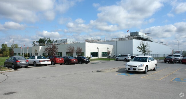
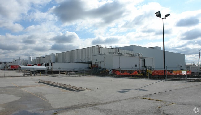
Property Record
2700 23Rd Ave, Council Bluffs, IA 51501

NEARBY LISTINGS FOR SALE OR LEASE
Property Detail
2700 23Rd Ave
Omaha-Council Bluffs, NE-IA
SECTION 3-74-44 W1270' N1490' S1530' W1/2 NE & E284' N1490' S1530' E1/2 NW EXC COMM~1270.13'E706.74'N CENTER SEC3 TH W468.45'N814.44' E474.74' S823.43' TO POB
7444-03-200-002
Pottawattamie
Officebuilding
Iowa
X
44
31153C0085G
42.97 AC
2025
Downtown Council Bluffs
2025
Omaha/Council Bluffs
031300
DEMOGRAPHICS near 2700 23Rd Ave
1 Mile
3 Mile
5 Mile
2024 Total Population
1,919
63,653
177,809
2029 Population
1,900
64,064
180,228
Pop Growth 2024-2029
(0.99%)
+ 0.65%
+ 1.36%
Average Age
38
38
37
2024 Total Households
753
26,236
69,866
HH Growth 2024-2029
(0.93%)
+ 0.84%
+ 1.52%
Median Household Inc
$49,480
$54,731
$51,178
Avg Household Size
2.50
2.30
2.30
2024 Avg HH Vehicles
2.00
2.00
2.00
Median Home Value
$143,801
$141,726
$157,897
Median Year Built
1964
1952
1956
Nearby Places
Map Layers
Map Styles
 Street
 Aerial
- Restaurants
- Banks
- Shops
- Fitness
- Groceries
PUBLIC TRANSPORTATION
COMMUTER RAIL
DRIVE
WALK
Distance
9 min
4.2 mi
DRIVE
WALK
Distance
10 min
4.4 mi
AIRPORT
Eppley Airfield
DRIVE
WALK
Distance
Eppley Airfield
17 min
7.1 mi
Nearby Properties
Address
Land Use
TOTAL SIZE
Lot Size
Zoning
Address
Land Use
TOTAL SIZE
Lot Size
Zoning
1,068,760 SF
1.72 AC
Address
Land Use
TOTAL SIZE
Lot Size
Zoning
62.66 AC
P-C
Address
Land Use
TOTAL SIZE
Lot Size
Zoning
603,518 SF
5.55 AC
CBD
Address
Land Use
TOTAL SIZE
Lot Size
Zoning
36.26 AC
P-C
Address
Land Use
TOTAL SIZE
Lot Size
Zoning
534,110 SF
4.35 AC
Address
Land Use
TOTAL SIZE
Lot Size
Zoning
30.39 AC
P-C
Address
Land Use
TOTAL SIZE
Lot Size
Zoning
52.44 AC
I-2
Address
Land Use
TOTAL SIZE
Lot Size
Zoning
362,402 SF
1.94 AC
Address
Land Use
TOTAL SIZE
Lot Size
Zoning
318,811 SF
11.51 AC
Address
Land Use
TOTAL SIZE
Lot Size
Zoning
254,306 SF
0.82 AC
Address
Land Use
TOTAL SIZE
Lot Size
Zoning
426,416 SF
1.55 AC
Address
Land Use
TOTAL SIZE
Lot Size
Zoning
16.18 AC
P-C
Address
Land Use
TOTAL SIZE
Lot Size
Zoning
50.56 AC
I-1
Address
Land Use
TOTAL SIZE
Lot Size
Zoning
346,816 SF
0.80 AC
Address
Land Use
TOTAL SIZE
Lot Size
Zoning
318,392 SF
7.77 AC
Address
Land Use
TOTAL SIZE
Lot Size
Zoning
4.22 AC
R-4
Address
Land Use
TOTAL SIZE
Lot Size
Zoning
319,440 SF
3.05 AC
Address
Land Use
TOTAL SIZE
Lot Size
Zoning
27.38 AC
I-2
Address
Land Use
TOTAL SIZE
Lot Size
Zoning
10.91 AC
R-3
Address
Land Use
TOTAL SIZE
Lot Size
Zoning
149,737 SF
1.93 AC
Address
Land Use
TOTAL SIZE
Lot Size
Zoning
274,024 SF
1.46 AC
Address
Land Use
TOTAL SIZE
Lot Size
Zoning
162,765 SF
0.42 AC
CBD
Address
Land Use
TOTAL SIZE
Lot Size
Zoning
281,014 SF
3.68 AC
Address
Land Use
TOTAL SIZE
Lot Size
Zoning
68.36 AC
R-1M
Address
Land Use
TOTAL SIZE
Lot Size
Zoning
98,202 SF
17.88 AC
P-C
Address
Land Use
TOTAL SIZE
Lot Size
Zoning
200,580 SF
3.22 AC
Address
Land Use
TOTAL SIZE
Lot Size
Zoning
0.89 AC
P-C
Address
Land Use
TOTAL SIZE
Lot Size
Zoning
37.25 AC
I-2
Address
Land Use
TOTAL SIZE
Lot Size
Zoning
15.96 AC
I-2
The World's #1 Commercial Real Estate Marketplace
Connect with us
© 2025 CoStar Group
The information above has been obtained from sources believed reliable. While we do not doubt its accuracy we have not verified it and make no guarantee, warranty or representation about it. It is your responsibility to independently confirm its accuracy and completeness. Any projections, opinions, assumptions, or estimates used are for example only and do not represent the current or future performance of the property. The value of this transaction to you depends on tax and other factors which should be evaluated by your tax, financial, and legal advisors. You and your advisors should conduct a careful, independent investigation of the property to determine to your satisfaction the suitability of the property for your needs.