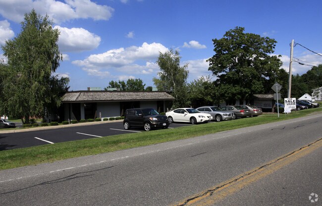
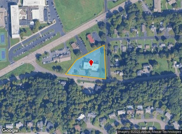
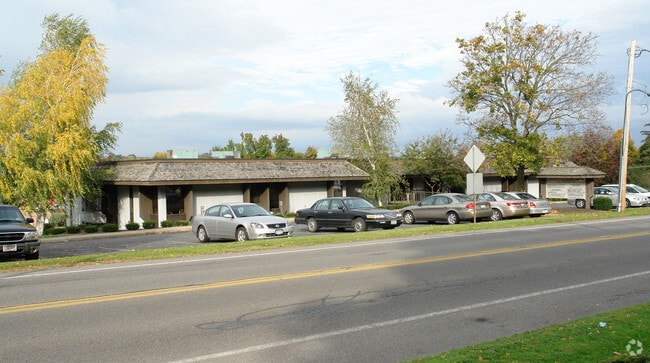
Property Record
2700 Bellevue Ave, Syracuse, NY 13219

NEARBY LISTINGS FOR SALE OR LEASE
Property Detail
2700 Bellevue Ave
314200-005-000-0013-002-001-0000
FL 73
Officebuilding
Onondaga
X
New York
36067C0214F
2.001
2025
1.73 AC
2024
W Outer Onondaga County
016400
Syracuse
16,576 SF
Syracuse, NY
DEMOGRAPHICS near 2700 Bellevue Ave
1 Mile
3 Mile
5 Mile
2024 Total Population
7,303
78,622
191,416
2029 Population
7,113
77,102
187,248
Pop Growth 2024-2029
(2.60%)
(1.93%)
(2.18%)
Average Age
44
39
38
2024 Total Households
3,168
32,431
77,352
HH Growth 2024-2029
(2.75%)
(2.05%)
(2.24%)
Median Household Inc
$71,217
$54,050
$50,200
Avg Household Size
2.20
2.30
2.20
2024 Avg HH Vehicles
2.00
1.00
1.00
Median Home Value
$171,598
$149,780
$150,131
Median Year Built
1956
1952
1953
Nearby Places
- Restaurants
- Banks
- Shops
- Fitness
- Groceries
PUBLIC TRANSPORTATION
COMMUTER RAIL
DRIVE
WALK
Distance
9 min
4.6 mi
DRIVE
WALK
Distance
12 min
4.8 mi
AIRPORT
Syracuse Hancock International
DRIVE
WALK
Distance
Syracuse Hancock International
19 min
9.4 mi
SALE & LEASE HISTORY
LISTING DATE
SALE/LEASE

Feb 09, 2021
For Sale
Apr 11, 2025
For Sale
Nearby Properties
Address
Land Use
TOTAL SIZE
Lot Size
Zoning
Address
Land Use
TOTAL SIZE
Lot Size
Zoning
57,011 SF
22.53 AC
22
Address
Land Use
TOTAL SIZE
Lot Size
Zoning
848,000 SF
30.29 AC
Address
Land Use
TOTAL SIZE
Lot Size
Zoning
32,324 SF
157.80 AC
08 - GOVER
Address
Land Use
TOTAL SIZE
Lot Size
Zoning
412,577 SF
39.43 AC
08 - GOVER
Address
Land Use
TOTAL SIZE
Lot Size
Zoning
522,469 SF
1.87 AC
14
Address
Land Use
TOTAL SIZE
Lot Size
Zoning
6,598 SF
4.09 AC
14
Address
Land Use
TOTAL SIZE
Lot Size
Zoning
108,368 SF
3.36 AC
14
Address
Land Use
TOTAL SIZE
Lot Size
Zoning
653,177 SF
1.94 AC
13
Address
Land Use
TOTAL SIZE
Lot Size
Zoning
316,848 SF
10.72 AC
08 - GOVER
Address
Land Use
TOTAL SIZE
Lot Size
Zoning
13,800 SF
2.10 AC
16
Address
Land Use
TOTAL SIZE
Lot Size
Zoning
275,732 SF
2.91 AC
13
Address
Land Use
TOTAL SIZE
Lot Size
Zoning
5,837 SF
1.26 AC
15
Address
Land Use
TOTAL SIZE
Lot Size
Zoning
31,947 SF
1.23 AC
Address
Land Use
TOTAL SIZE
Lot Size
Zoning
367,508 SF
0.48 AC
12
Address
Land Use
TOTAL SIZE
Lot Size
Zoning
23,650 SF
146.50 AC
06 - INDUS
Address
Land Use
TOTAL SIZE
Lot Size
Zoning
329,212 SF
2.11 AC
12
Address
Land Use
TOTAL SIZE
Lot Size
Zoning
79,344 SF
1.65 AC
14
Address
Land Use
TOTAL SIZE
Lot Size
Zoning
410,021 SF
2.22 AC
05 - COMME
Address
Land Use
TOTAL SIZE
Lot Size
Zoning
150,056 SF
48.64 AC
07 - MIXED
Address
Land Use
TOTAL SIZE
Lot Size
Zoning
23,212 SF
3.39 AC
22
Address
Land Use
TOTAL SIZE
Lot Size
Zoning
297,376 SF
1.88 AC
13
Address
Land Use
TOTAL SIZE
Lot Size
Zoning
8,784 SF
52.79 AC
Address
Land Use
TOTAL SIZE
Lot Size
Zoning
216,079 SF
17.57 AC
06 - INDUS
Address
Land Use
TOTAL SIZE
Lot Size
Zoning
215,578 SF
0.30 AC
13
Address
Land Use
TOTAL SIZE
Lot Size
Zoning
270,834 SF
29.38 AC
05 - COMME
Address
Land Use
TOTAL SIZE
Lot Size
Zoning
58,012 SF
21.64 AC
02 - SINGL
Address
Land Use
TOTAL SIZE
Lot Size
Zoning
15,000 SF
59.65 AC
02 - SINGL
Address
Land Use
TOTAL SIZE
Lot Size
Zoning
245,765 SF
12
Address
Land Use
TOTAL SIZE
Lot Size
Zoning
303,913 SF
74.20 AC
02 - SINGL
Address
Land Use
TOTAL SIZE
Lot Size
Zoning
377,454 SF
5.27 AC
15
The World's #1 Commercial Real Estate Marketplace
Connect with us
© 2025 CoStar Group
The information above has been obtained from sources believed reliable. While we do not doubt its accuracy we have not verified it and make no guarantee, warranty or representation about it. It is your responsibility to independently confirm its accuracy and completeness. Any projections, opinions, assumptions, or estimates used are for example only and do not represent the current or future performance of the property. The value of this transaction to you depends on tax and other factors which should be evaluated by your tax, financial, and legal advisors. You and your advisors should conduct a careful, independent investigation of the property to determine to your satisfaction the suitability of the property for your needs.