Property Record
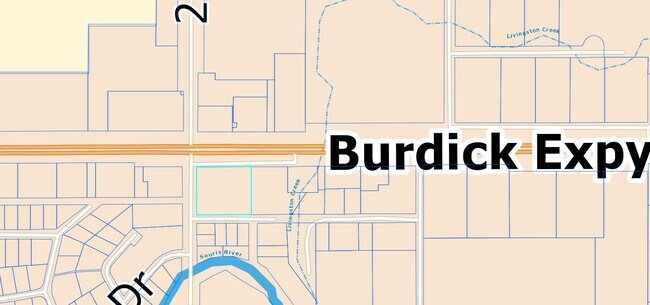
2700 Burdick Expy E, Minot, ND 58701

Property Detail
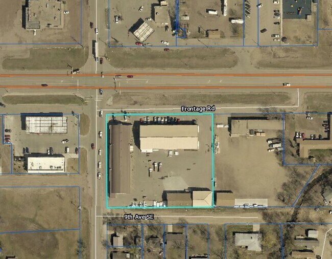
2700 Burdick Expy E
Minot, ND
TWN: 155 SCT: 20 RNG: 82 SUB: MI20288OUTLOTS SEC 20 155 82 SW1/4 SW1/4 OUTLOTS 1 AND 2
MI-20288-252-002-0
Ward
Realpropertynec
North Dakota
2025
1-2
2025
2 AC
010702
Riverwalk
12,000 SF
Other Market Areas
NEARBY LISTINGS FOR SALE OR LEASE
DEMOGRAPHICS near 2700 Burdick Expy E
1 mile
3 mile
5 mile
2025 Total Population
2,634
28,005
51,300
2030 Population
2,619
27,771
50,666
Pop Growth 2025-2030
(0.57%)
(0.84%)
(1.24%)
Average Age
34
38
38
2025 Total Households
1,060
11,974
21,963
HH Growth 2025-2030
(0.38%)
(0.85%)
(1.26%)
Median Household Inc
$72,668
$75,028
$75,189
Avg Household Size
2.40
2.20
2.20
2025 Avg HH Vehicles
2.00
2.00
2.00
Median Home Value
$192,968
$230,116
$259,796
Median Year Built
1977
1977
1983
Nearby Places
Map Layers
Map Styles
 Street
 Aerial
Layers
 Traffic
 Biking
Places
Listings with unknown addresses are not visible on the map
- Restaurants
- Banks
- Shops
- Fitness
- Groceries
PUBLIC TRANSPORTATION
COMMUTER RAIL
Minot Amtrak Station (Empire Builder - Amtrak)
Drive
Walk
Distance
Minot Amtrak Station (Empire Builder - Amtrak)
5 min
2.5 mi
AIRPORT
Minot International
Drive
Walk
Distance
Minot International
9 min
3.8 mi
Freight Ports
Port Milwaukee
Drive
Walk
Distance
Port Milwaukee
946 min
873.5 mi
Nearby Properties
Address
Land Use
TOTAL SIZE
Lot Size
Zoning
Address
Land Use
TOTAL SIZE
Lot Size
Zoning
41,710 SF
2.45 AC
Address
Land Use
TOTAL SIZE
Lot Size
Zoning
4,000 SF
59 AC
Address
Land Use
TOTAL SIZE
Lot Size
Zoning
13.96 AC
Address
Land Use
TOTAL SIZE
Lot Size
Zoning
45,052 SF
3.78 AC
Address
Land Use
TOTAL SIZE
Lot Size
Zoning
46,496 SF
2.41 AC
Address
Land Use
TOTAL SIZE
Lot Size
Zoning
33,600 SF
6.20 AC
Address
Land Use
TOTAL SIZE
Lot Size
Zoning
27,064 SF
5.23 AC
Address
Land Use
TOTAL SIZE
Lot Size
Zoning
24,471 SF
1.54 AC
Address
Land Use
TOTAL SIZE
Lot Size
Zoning
800 SF
4 AC
Address
Land Use
TOTAL SIZE
Lot Size
Zoning
18,600 SF
5.03 AC
Address
Land Use
TOTAL SIZE
Lot Size
Zoning
14,112 SF
1.71 AC
Address
Land Use
TOTAL SIZE
Lot Size
Zoning
4,460 SF
44 AC
Address
Land Use
TOTAL SIZE
Lot Size
Zoning
20.25 AC
Address
Land Use
TOTAL SIZE
Lot Size
Zoning
24,110 SF
5.83 AC
Address
Land Use
TOTAL SIZE
Lot Size
Zoning
36,158 SF
Address
Land Use
TOTAL SIZE
Lot Size
Zoning
6.83 AC
Address
Land Use
TOTAL SIZE
Lot Size
Zoning
28,600 SF
1.41 AC
Address
Land Use
TOTAL SIZE
Lot Size
Zoning
6,120 SF
0.53 AC
Address
Land Use
TOTAL SIZE
Lot Size
Zoning
19,520 SF
1.03 AC
Address
Land Use
TOTAL SIZE
Lot Size
Zoning
6,930 SF
0.51 AC
Address
Land Use
TOTAL SIZE
Lot Size
Zoning
121 AC
Address
Land Use
TOTAL SIZE
Lot Size
Zoning
17,326 SF
0.72 AC
Address
Land Use
TOTAL SIZE
Lot Size
Zoning
10,770 SF
1.09 AC
Address
Land Use
TOTAL SIZE
Lot Size
Zoning
5,400 SF
0.46 AC
Address
Land Use
TOTAL SIZE
Lot Size
Zoning
6,532 SF
0.05 AC
Address
Land Use
TOTAL SIZE
Lot Size
Zoning
10,142 SF
0.62 AC
Address
Land Use
TOTAL SIZE
Lot Size
Zoning
6,110 SF
0.46 AC
Address
Land Use
TOTAL SIZE
Lot Size
Zoning
34,584 SF
1.39 AC
Address
Land Use
TOTAL SIZE
Lot Size
Zoning
40.12 AC
The World's #1 Commercial Real Estate Marketplace
Connect with us
© 2026 CoStar Group
The information above has been obtained from sources believed reliable. While we do not doubt its accuracy we have not verified it and make no guarantee, warranty or representation about it. It is your responsibility to independently confirm its accuracy and completeness. Any projections, opinions, assumptions, or estimates used are for example only and do not represent the current or future performance of the property. The value of this transaction to you depends on tax and other factors which should be evaluated by your tax, financial, and legal advisors. You and your advisors should conduct a careful, independent investigation of the property to determine to your satisfaction the suitability of the property for your needs.