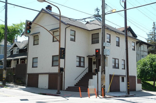
Property Record
2700 Channing Way, Berkeley, CA 94704

NEARBY LISTINGS FOR SALE OR LEASE
Property Detail
2700 Channing Way
Oakland-Fremont-Berkeley, CA
Ellsworth
055-1868-014-00
WESTERN49FT LOT6
Multifamilydwelling
Alameda
X
California
06001C0057G
6
2024
0.06 AC
2025
South Berkeley
422700
East Bay/Oakland
2,853 SF
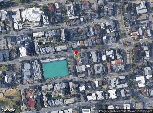
DEMOGRAPHICS near 2700 Channing Way
1 mile
3 mile
5 mile
2024 Total Population
47,725
209,646
406,969
2029 Population
46,581
203,957
397,107
Pop Growth 2024-2029
(2.40%)
(2.71%)
(2.42%)
Average Age
31
40
41
2024 Total Households
15,790
85,051
171,477
HH Growth 2024-2029
(2.24%)
(2.84%)
(2.51%)
Median Household Inc
$60,727
$109,823
$107,836
Avg Household Size
2.10
2.20
2.20
2024 Avg HH Vehicles
1.00
1.00
1.00
Median Home Value
$1,091,081
$1,096,771
$1,076,184
Median Year Built
1956
1949
1954
Nearby Places
Map Layers
Map Styles
 Street
 Aerial
Transit
 Traffic
 Biking
Places
Listings with unknown addresses are not visible on the map
- Restaurants
- Banks
- Shops
- Fitness
- Groceries
PUBLIC TRANSPORTATION
TRANSIT/SUBWAY
Downtown Berkeley Station (Fremont - Richmond - Bay Area Rapid Transit (BART), Richmond - Millbrae - Bay Area Rapid Transit (BART))
Drive
Walk
Distance
Downtown Berkeley Station (Fremont - Richmond - Bay Area Rapid Transit (BART), Richmond - Millbrae - Bay Area Rapid Transit (BART))
4 min
19 min
1.0 mi
COMMUTER RAIL
Drive
Walk
Distance
9 min
3.0 mi
Drive
Walk
Distance
11 min
3.5 mi
AIRPORT
Metro Oakland International
Drive
Walk
Distance
Metro Oakland International
24 min
14.4 mi
San Francisco International
Drive
Walk
Distance
San Francisco International
41 min
24.9 mi
Norman Y Mineta San Jose International
Drive
Walk
Distance
Norman Y Mineta San Jose International
59 min
44.8 mi
Freight Ports
Port of Oakland
Drive
Walk
Distance
Port of Oakland
13 min
5.7 mi
Nearby Properties
Address
Land Use
TOTAL SIZE
Lot Size
Zoning
Address
Land Use
TOTAL SIZE
Lot Size
Zoning
373,594 SF
16.16 AC
Address
Land Use
TOTAL SIZE
Lot Size
Zoning
501,460 SF
1.18 AC
Address
Land Use
TOTAL SIZE
Lot Size
Zoning
358,014 SF
5.03 AC
Address
Land Use
TOTAL SIZE
Lot Size
Zoning
167,071 SF
0.70 AC
Address
Land Use
TOTAL SIZE
Lot Size
Zoning
540,434 SF
14.37 AC
Address
Land Use
TOTAL SIZE
Lot Size
Zoning
395,549 SF
17.05 AC
Address
Land Use
TOTAL SIZE
Lot Size
Zoning
250,642 SF
17.05 AC
Address
Land Use
TOTAL SIZE
Lot Size
Zoning
197,135 SF
0.67 AC
Address
Land Use
TOTAL SIZE
Lot Size
Zoning
120,308 SF
1.52 AC
Address
Land Use
TOTAL SIZE
Lot Size
Zoning
371,322 SF
1.62 AC
Address
Land Use
TOTAL SIZE
Lot Size
Zoning
240,633 SF
1.59 AC
Address
Land Use
TOTAL SIZE
Lot Size
Zoning
261,134 SF
2.23 AC
Address
Land Use
TOTAL SIZE
Lot Size
Zoning
169,157 SF
10.20 AC
Address
Land Use
TOTAL SIZE
Lot Size
Zoning
224,160 SF
5.03 AC
Address
Land Use
TOTAL SIZE
Lot Size
Zoning
4.77 AC
Address
Land Use
TOTAL SIZE
Lot Size
Zoning
292,430 SF
2.09 AC
Address
Land Use
TOTAL SIZE
Lot Size
Zoning
397,378 SF
4.52 AC
Address
Land Use
TOTAL SIZE
Lot Size
Zoning
309,451 SF
0.87 AC
Address
Land Use
TOTAL SIZE
Lot Size
Zoning
2.29 AC
Address
Land Use
TOTAL SIZE
Lot Size
Zoning
238,118 SF
2.14 AC
Address
Land Use
TOTAL SIZE
Lot Size
Zoning
60,196 SF
0.43 AC
Address
Land Use
TOTAL SIZE
Lot Size
Zoning
60,670 SF
1.57 AC
Address
Land Use
TOTAL SIZE
Lot Size
Zoning
196,209 SF
3.14 AC
Address
Land Use
TOTAL SIZE
Lot Size
Zoning
123,750 SF
0.81 AC
Address
Land Use
TOTAL SIZE
Lot Size
Zoning
270,667 SF
2.76 AC
Address
Land Use
TOTAL SIZE
Lot Size
Zoning
254,000 SF
1.71 AC
Address
Land Use
TOTAL SIZE
Lot Size
Zoning
127,260 SF
5 AC
I
Address
Land Use
TOTAL SIZE
Lot Size
Zoning
203,859 SF
2.35 AC
Address
Land Use
TOTAL SIZE
Lot Size
Zoning
18,147 SF
0.40 AC
Address
Land Use
TOTAL SIZE
Lot Size
Zoning
131,862 SF
1.19 AC
The World's #1 Commercial Real Estate Marketplace
Connect with us
© 2026 CoStar Group
The information above has been obtained from sources believed reliable. While we do not doubt its accuracy we have not verified it and make no guarantee, warranty or representation about it. It is your responsibility to independently confirm its accuracy and completeness. Any projections, opinions, assumptions, or estimates used are for example only and do not represent the current or future performance of the property. The value of this transaction to you depends on tax and other factors which should be evaluated by your tax, financial, and legal advisors. You and your advisors should conduct a careful, independent investigation of the property to determine to your satisfaction the suitability of the property for your needs.