Property Record
2700 Crescent Springs Pike, Ft Mitchell, KY 41017
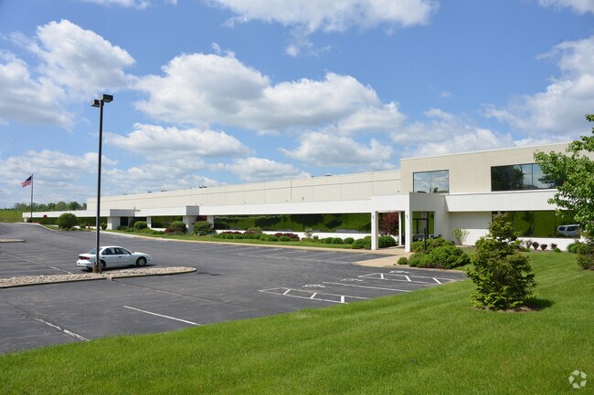

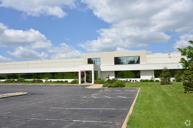
Property Detail
2700 Crescent Springs Pike
Cincinnati, OH-KY-IN
TEWES BUSINESS PARK PT LOTS 7A-7B-7C 16.94 AC WS CRESCENT SPRINGS RD INCL 10.00 AC PARCEL N LOTS 7C-7C
014-00-00-004.00
Kenton
Distributionwarehouseregional
Kentucky
A Areas with a 1% annual chance of flooding and a 26% chance of flooding over the life of a 30-year mortgage.
7a,7b
2025
16.94 AC
2025
Airport
067200
Cincinnati/Dayton
NEARBY LISTINGS FOR SALE OR LEASE
DEMOGRAPHICS near 2700 Crescent Springs Pike
1 mile
3 mile
5 mile
2025 Total Population
8,731
58,212
179,449
2030 Population
9,102
60,144
184,912
Pop Growth 2025-2030
+ 4.25%
+ 3.32%
+ 3.04%
Average Age
40
41
39
2025 Total Households
3,685
23,963
73,723
HH Growth 2025-2030
+ 4.02%
+ 3.26%
+ 3.11%
Median Household Inc
$80,186
$82,409
$70,648
Avg Household Size
2.30
2.30
2.30
2025 Avg HH Vehicles
2.00
2.00
2.00
Median Home Value
$288,296
$269,667
$224,438
Median Year Built
1980
1974
1965
Nearby Places
Map Layers
Map Styles
 Street
 Aerial
Layers
 Traffic
 Biking
Places
Listings with unknown addresses are not visible on the map
- Restaurants
- Banks
- Shops
- Fitness
- Groceries
PUBLIC TRANSPORTATION
COMMUTER RAIL
Cincinnati Union Terminal (Cardinal - Amtrak)
Drive
Walk
Distance
Cincinnati Union Terminal (Cardinal - Amtrak)
17 min
9.0 mi
AIRPORT
Cincinnati/Northern Kentucky International
Drive
Walk
Distance
Cincinnati/Northern Kentucky International
17 min
6.3 mi
Freight Ports
Port of Toledo
Drive
Walk
Distance
Port of Toledo
254 min
213.6 mi
Nearby Properties
Address
Land Use
TOTAL SIZE
Lot Size
Zoning
Address
Land Use
TOTAL SIZE
Lot Size
Zoning
Address
Land Use
TOTAL SIZE
Lot Size
Zoning
600 SF
196.95 AC
Address
Land Use
TOTAL SIZE
Lot Size
Zoning
82.25 AC
Address
Land Use
TOTAL SIZE
Lot Size
Zoning
157.77 AC
Address
Land Use
TOTAL SIZE
Lot Size
Zoning
46.68 AC
Address
Land Use
TOTAL SIZE
Lot Size
Zoning
20.38 AC
Address
Land Use
TOTAL SIZE
Lot Size
Zoning
20.52 AC
Address
Land Use
TOTAL SIZE
Lot Size
Zoning
475,250 SF
37.16 AC
Address
Land Use
TOTAL SIZE
Lot Size
Zoning
13.62 AC
Address
Land Use
TOTAL SIZE
Lot Size
Zoning
56.94 AC
Address
Land Use
TOTAL SIZE
Lot Size
Zoning
12.85 AC
Address
Land Use
TOTAL SIZE
Lot Size
Zoning
12.13 AC
Address
Land Use
TOTAL SIZE
Lot Size
Zoning
769,604 SF
14 AC
Address
Land Use
TOTAL SIZE
Lot Size
Zoning
Address
Land Use
TOTAL SIZE
Lot Size
Zoning
30.11 AC
Address
Land Use
TOTAL SIZE
Lot Size
Zoning
24.80 AC
Address
Land Use
TOTAL SIZE
Lot Size
Zoning
64,481 SF
16.99 AC
Address
Land Use
TOTAL SIZE
Lot Size
Zoning
177,200 SF
16.27 AC
Address
Land Use
TOTAL SIZE
Lot Size
Zoning
157,520 SF
18.05 AC
Address
Land Use
TOTAL SIZE
Lot Size
Zoning
50,536 SF
34.12 AC
Address
Land Use
TOTAL SIZE
Lot Size
Zoning
99.35 AC
Address
Land Use
TOTAL SIZE
Lot Size
Zoning
57,030 SF
7 AC
Address
Land Use
TOTAL SIZE
Lot Size
Zoning
16,406 SF
223.20 AC
Address
Land Use
TOTAL SIZE
Lot Size
Zoning
Address
Land Use
TOTAL SIZE
Lot Size
Zoning
85,726 SF
15.07 AC
Address
Land Use
TOTAL SIZE
Lot Size
Zoning
Address
Land Use
TOTAL SIZE
Lot Size
Zoning
176,588 SF
24.35 AC
Address
Land Use
TOTAL SIZE
Lot Size
Zoning
10.62 AC
Address
Land Use
TOTAL SIZE
Lot Size
Zoning
Address
Land Use
TOTAL SIZE
Lot Size
Zoning
194,304 SF
15.77 AC
The World's #1 Commercial Real Estate Marketplace
Connect with us
© 2026 CoStar Group
The information above has been obtained from sources believed reliable. While we do not doubt its accuracy we have not verified it and make no guarantee, warranty or representation about it. It is your responsibility to independently confirm its accuracy and completeness. Any projections, opinions, assumptions, or estimates used are for example only and do not represent the current or future performance of the property. The value of this transaction to you depends on tax and other factors which should be evaluated by your tax, financial, and legal advisors. You and your advisors should conduct a careful, independent investigation of the property to determine to your satisfaction the suitability of the property for your needs.